File:Russia Rail Map.svg

此SVG文件的PNG预览的大小:800 × 450像素。 其他分辨率:320 × 180像素 | 640 × 360像素 | 1,024 × 576像素 | 1,280 × 720像素 | 2,560 × 1,440像素 | 1,296 × 729像素。
原始文件 (SVG文件,尺寸为1,296 × 729像素,文件大小:140 KB)
摘要
| 描述 |
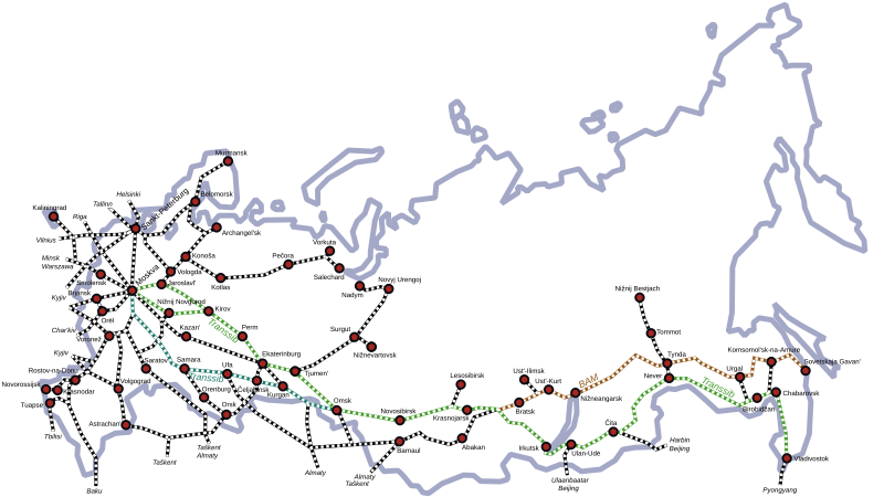
English: Russia's most important railway lines
Русский: Схема железных дорог Российской Федерации. |
| 日期 | (UTC) |
| 来源 | |
| 作者 |
|
| 其他版本 |
[]
|


|
此SVG檔案包含可翻譯至您的語言的内嵌文字,可以使用任何可用SVG編輯器、文本編輯器或SVG翻譯工具來翻譯。詳情請見:關於翻譯SVG檔案。 |
| 这是一张修改过的图片,这意味着它已在原版本的基础上通过软件进行了编辑,改动内容:vector version。其原始版本为:Russia Rail Map.png。修改者: Voland77。
|
许可协议
我,本作品著作权人,特此采用以下许可协议发表本作品:
| 我,本作品著作权人,释出本作品至公有领域。这适用于全世界。 在一些国家这可能不合法;如果是这样的话,那么: 我无条件地授予任何人以任何目的使用本作品的权利,除非这些条件是法律规定所必需的。 |
原始上传日志
This image is a derivative work of the following images:
- File:Russia_Rail_Map.png licensed with PD-self, PD-self/en
- 2007-09-02T21:36:21Z Voland77 1296x729 (350075 Bytes) {{Information |Description=Russia's most important railway lines |Source=own work |Date=2007-09-02 |Author=Voland77 |Permission= |other_versions= }}
Uploaded with derivativeFX
文件历史
点击某个日期/时间查看对应时刻的文件。
| 日期/时间 | 缩略图 | 大小 | 用户 | 备注 | |
|---|---|---|---|---|---|
| 当前 | 2017年5月22日 (一) 14:16 | | 1,296 × 729(140 KB) | Carfois | - Colored in emerald color the historical Transsiberian line. - Colored in green the route via Nižnij Novgorod used today by the Transsiberian trains № 002М/001М «Россия» like the other route, via Jaroslavl', used today by the other Transs... |
| 2017年5月21日 (日) 10:33 |  | 1,296 × 729(138 KB) | Carfois | - Added Ufa, Perm, Krasnodar - Corrected Birobidžan position - Added layers in the file (please don't remove them) | |
| 2011年12月19日 (一) 13:35 |  | 1,296 × 729(139 KB) | Insider | fix Belomorsk and Oboserskaya-Belomorsk railway | |
| 2009年2月10日 (二) 22:12 |  | 1,296 × 729(134 KB) | Voland77 | {{Information |Description=Russia's most important railway lines |Source=*File:Russia_Rail_Map.png |Date=2009-02-10 22:12 (UTC) |Author=*File:Russia_Rail_Map.png: Voland77 *derivative work: ~~~ |Permission=see below |other_versions= }} {{Reto |
文件用途
全域文件用途
以下其他wiki使用此文件:
- ab.wikipedia.org上的用途
- ast.wikipedia.org上的用途
- bg.wikipedia.org上的用途
- da.wikipedia.org上的用途
- de.wikipedia.org上的用途
- en.wikipedia.org上的用途
- es.wikipedia.org上的用途
- fa.wikipedia.org上的用途
- fr.wikipedia.org上的用途
- he.wikipedia.org上的用途
- he.wikivoyage.org上的用途
- hu.wikipedia.org上的用途
- id.wikipedia.org上的用途
- ja.wikipedia.org上的用途
- mr.wikipedia.org上的用途
- no.wikipedia.org上的用途
- ro.wikipedia.org上的用途
- ru.wikipedia.org上的用途
- simple.wikipedia.org上的用途
- sv.wikipedia.org上的用途
- th.wikipedia.org上的用途
- uk.wikipedia.org上的用途