File:Rzeczpospolita Royal Ducal.png
此为最大尺寸。
Rzeczpospolita_Royal_Ducal.png (686 × 508像素,文件大小:144 KB,MIME类型:image/png)

|
此map图片可使用矢量图形重新创建为SVG文件。这具有很多好处;更多信息请参见共享资源:待清理媒体。如果存在此图片的SVG格式,请将其上传,然后将此模板替换为
{{vector version available|新图片名称}}。
建议您将SVG命名为“Rzeczpospolita Royal Ducal.svg”,这样在使用Vector version available(或Vva)模板时就不需要填写新图片名称参数。 |
摘要
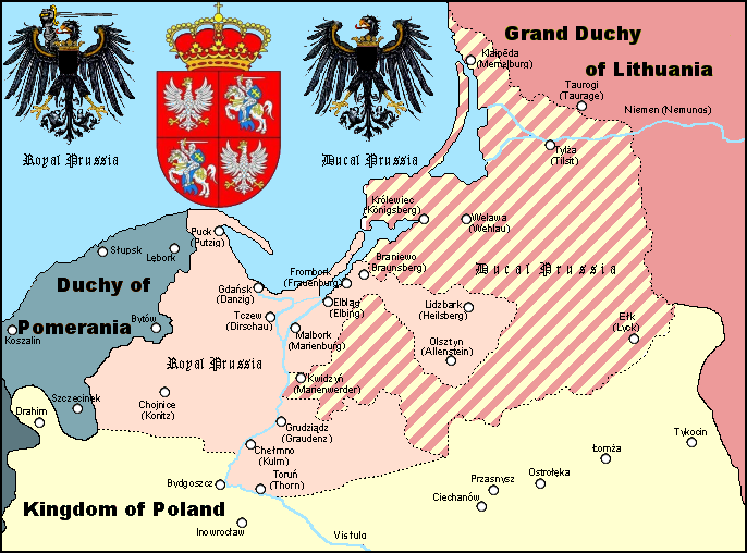
A Polish Wikipedian made version of Royal and Ducal Prussia around 1575.
Made by Halibutt in GIMP, based on an earlier GFDL map by w:User:Space Cadet and Halibutt's "Rzeczpospolita" map series.
| Kingdom of Poland | Since 1569 Polish-Lithuanian Commonwealth | |
| Grand Duchy of Lithuania | Since 1569 Polish-Lithuanian Commonwealth | |
| Royal Prussia | Pomeranian, Malbork, Chełmno Voivodships and bishopry of Warmia | |
| Ducal Prussia | Polish fief | |
| Duchy of Pomerania | Part of the Holy Roman Empire (since 1600s: "...of the German Nation") | |
| Brandenburg | Part of the Holy Roman Empire (since 1600s: "...of the German Nation") |

|
一旦在圖像本身中可見的文本信息(例如時間戳)已移動到圖像元數據和/或圖像描述頁面。 這使圖像更易於重用且更不依賴語言,並使文本更易於處理和搜索。共享資源勸阻在圖像中放置可見的文本信息。共享資源接受的所有許可證都允許將這種類型的修改作為衍生作品進行。
如果屬性信息被刪除並且圖像不是公共領域,請將此標記替換為{{Attribution metadata from licensed image}}。
|
许可协议
Since the legal status of the above comment has been questioned, I hereby grant anyone the right to treat it as either a standard copyright notice, invariant section, legal statement, legal advice, friendly suggestion or a mere comment, depending on his or hers own choice. |
|

The following is a list of maps created by Halibutt and uploaded to commons, as well as their present and projected derivatives.
| Parent Image | Image | Description | |||||||||||
|---|---|---|---|---|---|---|---|---|---|---|---|---|---|
| Maps by Halibutt | |||||||||||||
| Image:Rzeczpospolita.png | Image:Rzeczpospolita.png | The Republic in 17th and 18th century | |||||||||||
| Image:Rzeczpospolita 1600.png | The Republic after the Treaty of Dywilino | ||||||||||||
| Image:Rzeczpospolita voivodships.png | Voivodships of The Republic | ||||||||||||
| Image:Rzeczpospolita_Potop.png | The Republic during The Deluge and Chmielnicki Uprising, with major battles of the era marked | ||||||||||||
| Magnates and their lands and domains | |||||||||||||
| 1st • 2nd • 3rd | Partitions of Poland | ||||||||||||
| War of the constitution | |||||||||||||
| Image:Rzeczpospolita.xcf | SOURCE FILE - GIMP format | ||||||||||||
| Image:Poland 1939.png | Image:Poland 1939.png | Poland in 1939 | |||||||||||
| Image:Dywizje wrzesien 1.png | Order of Battle on September 1st, during the Polish Defence War of 1939 | ||||||||||||
| Image:Poland 1939.xcf | SOURCE FILE - GIMP format | ||||||||||||
| Image:Polska kontur bialy.png | Image:Polska kontur bialy.png | Contour map of Poland AD 1999, for use with various locator maps | |||||||||||
| Image:Rzeczpospolita 1923.png | Image:Rzeczpospolita 1923.png | Map of Poland 1918-1939, currently under development | |||||||||||
| Image:PBW March 1919.png | Polish-Bolshevik War - fronts in March of 1919 | ||||||||||||
| Image:PBW December 1919.png | Polish-Bolshevik War - fronts in December of 1919 | ||||||||||||
| Image:PBW June 1920.png | Polish-Bolshevik War - fronts in July of 1920 | ||||||||||||
| Image:PBW August 1920.png | Polish-Bolshevik War - fronts in August of 1920 | ||||||||||||
| Polish Defence War of 1939 | |||||||||||||
| Polish areas annexed by Germany, Lithuania, Slovakia and the Soviet Union | |||||||||||||
| German concentration camps in Poland | |||||||||||||
| Curzon line | |||||||||||||
| Major battles of the Polish-Bolshevik War | |||||||||||||
| names • no names | Polish/Czechoslovak/Lithuanian/German/Ukrainian claims in 1920's | ||||||||||||
| Image:Rzeczpospolita Central Lithuania.png | Central Lithuania | ||||||||||||
| Image:Rzeczpospolita Lithuania claims.png | Central Lithuania as compared with other Lithuanian claims | ||||||||||||
| Image:Rzeczpospolita 1789-1920.png | Post-1922 borders compared with the territory of Poland before the partitions | ||||||||||||
| Warsaw Uprising and the Operation Tempest | |||||||||||||
| Poland partitioned between the Soviets and the Germans | |||||||||||||
| Image:Rzeczpospolita 1939 Polish divisions.png | Polish divisions on September 1, 1939 | ||||||||||||
| Home Army inspectorates | |||||||||||||
| Image:Rzeczpospolita 1922.xcf | SOURCE FILE - GIMP format | ||||||||||||
| Image:Rzeczpospolita 1937.svg | Vector version!!!! | layered version available on request | |||||||||||
文件历史
点击某个日期/时间查看对应时刻的文件。
| 日期/时间 | 缩略图 | 大小 | 用户 | 备注 | |
|---|---|---|---|---|---|
| 当前 | 2023年4月3日 (一) 12:44 | | 686 × 508(144 KB) | Natus37 | Wappenkorr. (-rote Flecke) |
| 2013年2月19日 (二) 21:30 |  | 686 × 508(127 KB) | Jbarta | remove caption, minor fix | |
| 2006年2月28日 (二) 16:27 |  | 686 × 534(141 KB) | Halibutt | A map of Royal and Ducal Prussia around 1575, made by Halibutt in GIMP, based on an [http://upload.wikimedia.org/wikipedia/en/archive/c/cb/20041019104150%21Royal_Ducal.png earlier GFDL map] by w:User:Space Cadet and Halibutt's "Rzeczpospolita" map se |
文件用途
以下2个页面使用本文件:
全域文件用途
以下其他wiki使用此文件:
- an.wikipedia.org上的用途
- ar.wikipedia.org上的用途
- ast.wikipedia.org上的用途
- az.wikipedia.org上的用途
- be.wikipedia.org上的用途
- ca.wikipedia.org上的用途
- cs.wikipedia.org上的用途
- da.wikipedia.org上的用途
- de.wikipedia.org上的用途
- el.wikipedia.org上的用途
- en.wikipedia.org上的用途
- eo.wikipedia.org上的用途
- et.wikipedia.org上的用途
- fi.wikipedia.org上的用途
- fr.wikipedia.org上的用途
- gl.wikipedia.org上的用途
- he.wikipedia.org上的用途
- hu.wikipedia.org上的用途
- id.wikipedia.org上的用途
- it.wikipedia.org上的用途
查看本文件的更多全域用途。