File:Scarborough Shoal Landsat.jpg

本预览的尺寸:800 × 518像素。 其他分辨率:320 × 207像素 | 640 × 415像素 | 1,000 × 648像素。
原始文件 (1,000 × 648像素,文件大小:97 KB,MIME类型:image/jpeg)
摘要
| 描述 |
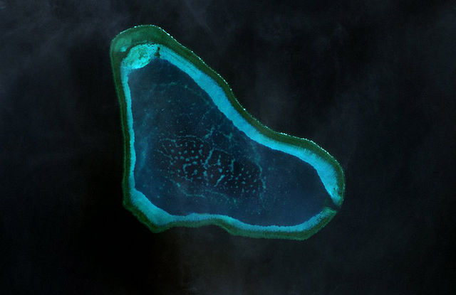
Deutsch: Landsat-7-Bild des Scarborough-Riffs im Westphilippinischen Meer
|
| 日期 | |
| 来源 | http://www.oceandots.com/pacific/scarborough/scarborough2.php |
| 作者 | NASA |
| 这是一张修改过的图片,这意味着它已在原版本的基础上通过软件进行了编辑,改动内容:color adjusted。
|
许可协议
| 本文件完全由NASA创作,在美国属于公有领域。根据NASA的版权方针,NASA的材料除非另有声明否则不受版权保护。(参见Template:PD-USGov/zh、NASA版权方针页面或JPL图片使用方针。) | ||
 |
警告:
|
文件历史
点击某个日期/时间查看对应时刻的文件。
| 日期/时间 | 缩略图 | 大小 | 用户 | 备注 | |
|---|---|---|---|---|---|
| 当前 | 2010年2月22日 (一) 14:41 | | 1,000 × 648(97 KB) | Telim tor | == {{int:filedesc}} == {{Information |Description= {{de|Landsat-7-Bild des Scarborough-Riffs im Südchinesischen Meer}} {{en|Landsat 7 image of Scarborough Shoal in the South China Sea}} |Source=http://www.oceandots.com/pacific/scarborough/scarborough2.ph |
文件用途
全域文件用途
以下其他wiki使用此文件:
- ca.wikipedia.org上的用途
- cs.wikipedia.org上的用途
- de.wikipedia.org上的用途
- en.wikipedia.org上的用途
- es.wikipedia.org上的用途
- fa.wikipedia.org上的用途
- fi.wikipedia.org上的用途
- fr.wikipedia.org上的用途
- it.wikipedia.org上的用途
- ja.wikipedia.org上的用途
- ko.wikipedia.org上的用途
- mk.wikipedia.org上的用途
- sv.wikipedia.org上的用途
- tl.wikipedia.org上的用途
- tr.wikipedia.org上的用途
- vi.wikipedia.org上的用途
- www.wikidata.org上的用途
- zh-yue.wikipedia.org上的用途