File:Serbia1913.png

本预览的尺寸:436 × 600像素。 其他分辨率:174 × 240像素 | 349 × 480像素 | 663 × 912像素。
原始文件 (663 × 912像素,文件大小:58 KB,MIME类型:image/png)
摘要
| 描述 |
Description=
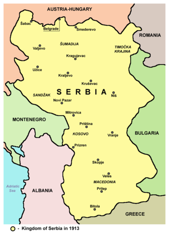
Српски / srpski: Mapa Kraljevine Srbije 1913. godine - teritorijalno proširenje nakon Balkanskih ratova. |
| 日期 | |
| 来源 | 自己的作品 |
| 作者 | PANONIAN |
Source and licence
Self-made map by PANONIAN
| 本作品已被作者PANONIAN释出到公有领域。这适用于全世界。 在一些国家这可能不合法;如果是这样的话,那么: |

|
This map has been uploaded by Electionworld from en.wikipedia.org to enable the |
References
- The Times History of Europe, Times Books, London, 2002.
- Richard Overy, The Times History of the 20th Century, Times Books, London, 2004.
- Noel Malcolm, Kosovo - A Short History, Pan Books, London, 2002.
- Istorijski atlas, Geokarta, Beograd, 1999.
- Denis Šehić - Demir Šehić, Istorijski atlas Sveta, Beograd, 2007.
- Školski istorijski atlas, Zavod za izdavanje udžbenika SR Srbije, Beograd, 1970.
- Sve srpske mape - od šestog veka do Pariza, Specijalno izdanje BLICA, Decembar 1995
- Dr Tomislav Bogavac, Nestajanje Srba, Niš, 1994.
- http://www.amitm.com/thecon/1913.jpg
- http://www.zum.de/whkmla/histatlas/europe/eu1913t.gif
- http://tonalsoft.com/enc/v/viennafiles/europe1914.gif
- http://academic.evergreen.edu/g/grossmaz/Balkans1913.jpg
- http://www.transanatolie.com/English/Turkey/Turks/balkan6.gif
- http://www.nationalarchives.gov.uk/pathways/firstworldwar/maps/map_images/Europe1914.gif
- http://www.worldmapsonline.com/UnivHist/30422_6.gif
- http://www.internationalschooltoulouse.net/projects/versailles/2006/images/europe_1871_1914.jpg
- http://www.codoh.com/graphics2/europ1914hlf.jpeg
- http://www.fabian-vendrig.eu/balkan/mk/images/macedonb.jpg
- http://www.worldwar1.com/maps/balkan.jpg
- http://faculty.unlv.edu/pwerth/Balkansmap-1914.jpg
- http://www.aag.org/Education/center/cgge-aag%20site/Nationalism/images/balkans_1913.jpg
- http://www.sahistory.org.za/pages/hands-on-classroom/classroom/pages/projects/grade8/lesson7/graphics/austria-hungary.jpg
- http://history.sandiego.edu/GEN/WW1Pics2/93334.jpg
- http://www.zum.de/whkmla/histatlas/balkans/serbia1914.gif
- https://www.nytimes.com/specials/bosnia/context/yugo1914.gif
derivative works
此文件衍生的作品:
文件历史
点击某个日期/时间查看对应时刻的文件。
| 日期/时间 | 缩略图 | 大小 | 用户 | 备注 | |
|---|---|---|---|---|---|
| 当前 | 2012年9月17日 (一) 19:35 | | 663 × 912(58 KB) | PANONIAN | minor easthetical change - fixing image border |
| 2010年1月18日 (一) 00:09 |  | 659 × 910(57 KB) | Bidgee | I'll allow the new version | |
| 2010年1月18日 (一) 00:03 |  | 582 × 831(18 KB) | Bidgee | Reverted to version as of 21:38, 21 December 2006 While the image does expand on the original please do not upload over it, upload the improved map under a new name. | |
| 2010年1月16日 (六) 20:30 |  | 659 × 910(57 KB) | PANONIAN | improved version | |
| 2006年12月21日 (四) 21:38 |  | 582 × 831(18 KB) | Electionworld | {{ew|en|PANONIAN}} Self-made map by PANONIAN {{PD-user|PANONIAN}} Category:Maps of Serbia |
文件用途
以下页面使用本文件:
全域文件用途
以下其他wiki使用此文件:
- azb.wikipedia.org上的用途
- ba.wikipedia.org上的用途
- be-tarask.wikipedia.org上的用途
- be.wikipedia.org上的用途
- bg.wikipedia.org上的用途
- bs.wikipedia.org上的用途
- ca.wikipedia.org上的用途
- cs.wikipedia.org上的用途
- el.wikipedia.org上的用途
- en.wikipedia.org上的用途
- et.wikipedia.org上的用途
- eu.wikipedia.org上的用途
- fa.wikipedia.org上的用途
- fr.wikipedia.org上的用途
- gl.wikipedia.org上的用途
- he.wikipedia.org上的用途
- hr.wikipedia.org上的用途
- it.wikipedia.org上的用途
- ja.wikipedia.org上的用途
- ko.wikipedia.org上的用途
- lt.wikipedia.org上的用途
- mn.wikipedia.org上的用途
- nl.wikipedia.org上的用途
- pl.wikipedia.org上的用途
- pnb.wikipedia.org上的用途
- pt.wikipedia.org上的用途
- ro.wikipedia.org上的用途
- sh.wikipedia.org上的用途
- sk.wikipedia.org上的用途
- sl.wikipedia.org上的用途
- sq.wikipedia.org上的用途
查看本文件的更多全域用途。