File:Serbia in the Yugoslav Wars.png
本预览的尺寸:800 × 555像素。 其他分辨率:320 × 222像素 | 640 × 444像素 | 1,024 × 711像素 | 1,285 × 892像素。
原始文件 (1,285 × 892像素,文件大小:130 KB,MIME类型:image/png)

|
此military map图片可使用矢量图形重新创建为SVG文件。这具有很多好处;更多信息请参见共享资源:待清理媒体。如果存在此图片的SVG格式,请将其上传,然后将此模板替换为
{{vector version available|新图片名称}}。
建议您将SVG命名为“Serbia in the Yugoslav Wars.svg”,这样在使用Vector version available(或Vva)模板时就不需要填写新图片名称参数。 |
摘要
| 描述 |
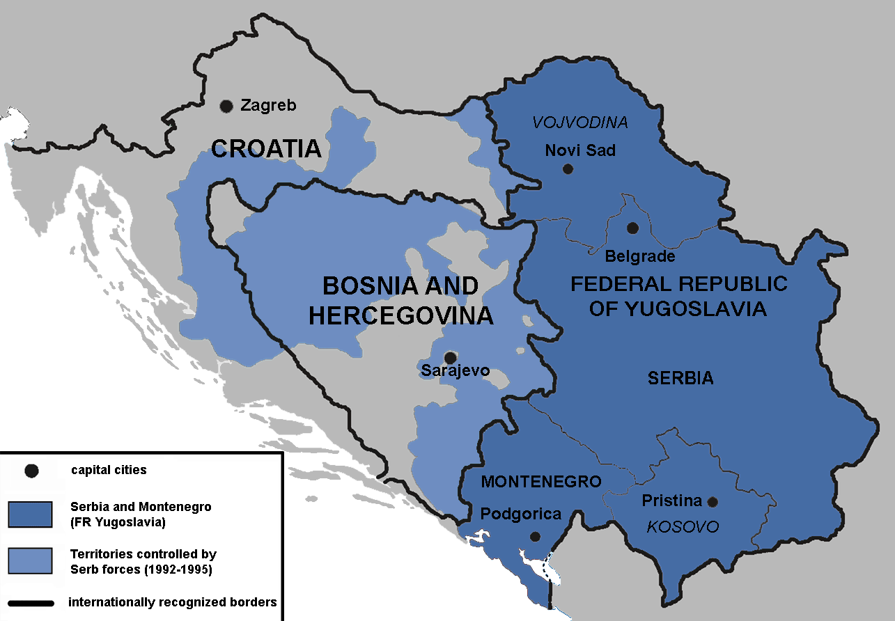
English: Territories of the Republic of Bosnia and Herzegovina and the Republic of Croatia controlled by the Serb forces, after the Operation Corridor (July 1992) in the Yugoslav Wars.
According to the prosecution of War Crimes Tribunal, "Serbian forces" included Yugoslav Army, Serb Territorial Defense of Bosnia and Herzegovina and Croatia, Republic of Srpska Krajina Army, Army of the Republika Srpska, territorial defense of Serbia and Montenegro, Police of Serbia and Police of Republika Srpska, including national security, special police forces of Krajina known as "Martićevci", as well as all Serbian paramilitary forces and volunteer units.[1] Croatia declared independence on June 25, 1991. It was internationally recognized on 15 January 1992 by the United Nations. Bosnia and Herzegovina declared independence on March 5 1992. It was internationally recognized on 22 May 1992 by the United Nations. Serbia and Montenegro proclaimed FR Yugoslavia as a sole successor state of SFR Yugoslavia, on April 27 1992. It remained unrecognized during the conflict (1991-1995). |
||
| 日期 | |||
| 来源 | 自己的作品 | ||
| 作者 | Mladifilozof | ||
| 授权 (二次使用本文件) |
我,本作品著作权人,特此采用以下许可协议发表本作品: 本文件采用知识共享署名-相同方式共享 3.0 未本地化版本许可协议授权。
您可以选择您需要的许可协议。 |
||
| 其他版本 |
|


- ↑ Šešelj ICTY Case information sheet (retrieved 10.07.2009.)
文件历史
点击某个日期/时间查看对应时刻的文件。
| 日期/时间 | 缩略图 | 大小 | 用户 | 备注 | |
|---|---|---|---|---|---|
| 当前 | 2019年1月13日 (日) 16:09 | | 1,285 × 892(130 KB) | Illegitimate Barrister | labelled FRoY |
| 2012年8月11日 (六) 23:50 |  | 1,285 × 892(106 KB) | DIREKTOR | Small fix | |
| 2012年4月3日 (二) 00:14 |  | 1,285 × 892(76 KB) | Phoenix B 1of3 | The blue map appears clearer and easier to understand | |
| 2012年4月2日 (一) 11:34 |  | 1,285 × 892(83 KB) | Fezz5555 | Returning the original previous image of the author. | |
| 2011年12月10日 (六) 23:27 |  | 1,285 × 892(76 KB) | DIREKTOR | Colour | |
| 2010年2月22日 (一) 04:12 |  | 1,285 × 892(83 KB) | Mladifilozof | improved | |
| 2010年2月16日 (二) 20:24 |  | 1,285 × 892(89 KB) | Mladifilozof | {{Information |Description={{en|1=Territories of the Republic of Bosnia and Herzegovina and the Republic of Croatia controlled by the Serbian forces during the [[:en:Yugoslav Wars|Yugo |
文件用途
全域文件用途
以下其他wiki使用此文件:
- ar.wikipedia.org上的用途
- azb.wikipedia.org上的用途
- az.wikipedia.org上的用途
- be.wikipedia.org上的用途
- bg.wikipedia.org上的用途
- bs.wikipedia.org上的用途
- ca.wikipedia.org上的用途
- cs.wikipedia.org上的用途
- da.wikipedia.org上的用途
- de.wikipedia.org上的用途
- el.wikipedia.org上的用途
- en.wikipedia.org上的用途
- Siege of Sarajevo
- Greater Serbia
- Bosnian genocide
- Republika Srpska (1992–1995)
- Talk:Republika Srpska (1992–1995)
- Croatian War of Independence
- Talk:Joint criminal enterprise
- Talk:Republic of Bosnia and Herzegovina
- Talk:Bosnian War/Archive 3
- Serbia in the Yugoslav Wars
- Talk:Republic of Serbian Krajina/Archive 3
- Talk:Bosnian genocide/Archive 4
- Wikipedia:Graphics Lab/Map workshop/Archive/Oct 2011
- User:Phoenix B 1of3/Stop Greater Serbia
- Talk:Slobodan Milošević/Archive 2
- Talk:Siege of Sarajevo/Archive 1
- Agreement on Friendship and Cooperation between Bosnia and Herzegovina and Croatia
- Talk:Operation Corridor 92/Archive 1
- Proposed secession of Republika Srpska
- User:Falcaorib
- Talk:History of Serbia/Archive 1
- Talk:Republic of Serbia (1992–2006)/Archive 1
- Talk:Russia/Archive 16
- es.wikipedia.org上的用途
- eu.wikipedia.org上的用途
- fr.wikipedia.org上的用途
- gl.wikipedia.org上的用途
- he.wikipedia.org上的用途
查看本文件的更多全域用途。