File:Shameen Canton.jpg

本预览的尺寸:800 × 375像素。 其他分辨率:320 × 150像素 | 640 × 300像素 | 1,024 × 480像素 | 1,280 × 600像素 | 2,560 × 1,200像素 | 11,584 × 5,430像素。
原始文件 (11,584 × 5,430像素,文件大小:10.84 MB,MIME类型:image/jpeg)
| 警告 | 部分浏览器在浏览此图片的完整大小时可能会遇到困难:该图片中有数量巨大的像素点,可能无法完全载入或者导致您的浏览器停止响应。 |
|---|
摘要
| 描述 |
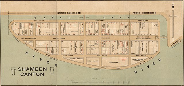
English: Cadastral map of Shameen [i.e. Shamian Island] in Canton [i.e. Guangzhou]. It is one mile in circumference and lies just off Canton, which has always been a center of commerce, competing with Hong Kong, only sixty miles away. Because the island was a British and French Concession, it was carefully patrolled and connected to the mainland on the northern side by the carefully-guarded "English Bridge" and a French Bridge on the eastern side. The larger western part was English and the eastern part French. Each had its own municipal offices, even its own police forces, Sikhs for the British, Annamites for the French. The map shows in detail the use of the offices and buildings on the island. 中文(繁體):廣州市沙面島的地圖,使用粵音「Shameen」標註。藏於澳洲國家圖書館。 |
| 日期 | 在1920年到1929年之间 |
| 来源 | http://nla.gov.au/nla.map-brsc67 |
| 作者 | 未知 |
许可协议
|
本作品在其来源国以及其他著作权期限是作者逝世后70年或以下的国家和地区属于公有领域。
| |
| 本文件已被确认为免除已知的著作权法限制(包括所有相关权利)。 | |
| 註解 | 該圖片含有註解:在維基媒體共享資源上查看註解 |
文件历史
点击某个日期/时间查看对应时刻的文件。
| 日期/时间 | 缩略图 | 大小 | 用户 | 备注 | |
|---|---|---|---|---|---|
| 当前 | 2018年1月19日 (五) 05:59 | | 11,584 × 5,430(10.84 MB) | User-duck | Cropped using CropTool with lossless mode. |
| 2013年2月26日 (二) 09:35 |  | 11,984 × 5,952(12 MB) | Gzdavidwong | User created page with UploadWizard |
文件用途
全域文件用途
以下其他wiki使用此文件:
- en.wikipedia.org上的用途
- fr.wikipedia.org上的用途
- it.wikipedia.org上的用途
- ja.wikipedia.org上的用途
- no.wikipedia.org上的用途
- pt.wikipedia.org上的用途
- ru.wikipedia.org上的用途
- tr.wikipedia.org上的用途
- vi.wikipedia.org上的用途
- zh-yue.wikipedia.org上的用途