File:South China Sea vector.svg

此SVG文件的PNG预览的大小:637 × 600像素。 其他分辨率:255 × 240像素 | 510 × 480像素 | 816 × 768像素 | 1,088 × 1,024像素 | 2,176 × 2,048像素 | 1,004 × 945像素。
原始文件 (SVG文件,尺寸为1,004 × 945像素,文件大小:657 KB)
摘要
| 描述 |
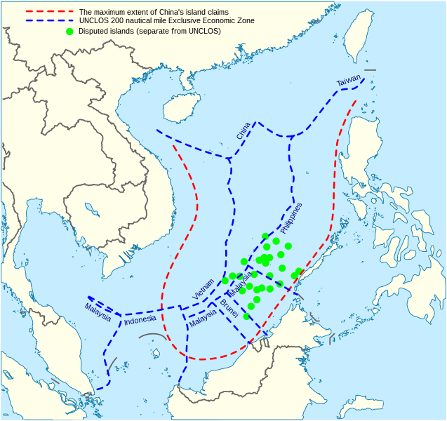
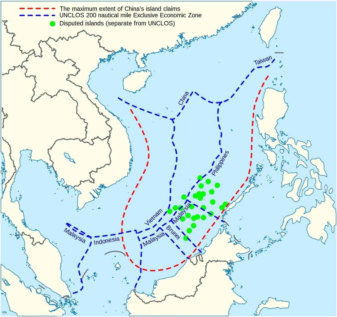
English: China's maritime claim (red) and UNCLOS exclusive economic zones (blue) in the South China Sea |
| 日期 | |
| 来源 |
自己的作品 |
| 作者 | Goran tek-en |
| SVG开发 |


许可协议
本文件采用知识共享署名-相同方式共享 4.0 国际许可协议授权。
署名: Goran tek-en
- 您可以自由地:
- 共享 – 复制、发行并传播本作品
- 修改 – 改编作品
- 惟须遵守下列条件:
- 署名 – 您必须对作品进行署名,提供授权条款的链接,并说明是否对原始内容进行了更改。您可以用任何合理的方式来署名,但不得以任何方式表明许可人认可您或您的使用。
- 相同方式共享 – 如果您再混合、转换或者基于本作品进行创作,您必须以与原先许可协议相同或相兼容的许可协议分发您贡献的作品。
文件历史
点击某个日期/时间查看对应时刻的文件。
| 日期/时间 | 缩略图 | 大小 | 用户 | 备注 | |
|---|---|---|---|---|---|
| 当前 | 2022年2月15日 (二) 14:31 | | 1,004 × 945(657 KB) | ماني | File uploaded using svgtranslate tool (https://svgtranslate.toolforge.org/). Added translation for fa. |
| 2021年11月16日 (二) 15:44 |  | 1,004 × 945(651 KB) | Goran tek-en | ppi to 96, optimized, cleaned up | |
| 2014年11月9日 (日) 19:40 |  | 1,004 × 945(729 KB) | Cmglee | Label UNCLOS regions. | |
| 2014年5月19日 (一) 23:15 |  | 1,004 × 945(723 KB) | Benlisquare | Fix misinformation, see en:Talk:Nine-dotted line. The red line represents the extent of China's island claims, and not sea territory claims. China's maritime territorial claims are based on distance from claimed islands, and are not demarcated by... | |
| 2014年1月23日 (四) 14:40 |  | 1,004 × 945(722 KB) | Goran tek-en | User created page with UploadWizard |
文件用途
没有页面链接到本图像。
全域文件用途
以下其他wiki使用此文件:
- af.wikipedia.org上的用途
- cs.wikinews.org上的用途
- en.wikipedia.org上的用途
- fa.wikipedia.org上的用途
- fi.wikipedia.org上的用途
- fr.wikinews.org上的用途
- fr.wiktionary.org上的用途
- ja.wikipedia.org上的用途
- kk.wikipedia.org上的用途
- ko.wikipedia.org上的用途
- pl.wikipedia.org上的用途
- ru.wikipedia.org上的用途
- th.wikipedia.org上的用途
- vi.wikipedia.org上的用途