File:South asia.jpg
此为最大尺寸。
South_asia.jpg (425 × 533像素,文件大小:52 KB,MIME类型:image/jpeg)
摘要
| 描述 |
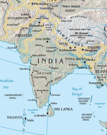
Import from File:South asia.jpg 26 July 2008 English: The image is cropped from en:Image:Sino-Indian Geography.png, created and published by the en:Central Intelligence Agency of the en:United States of America in en:2004.
NoteThis map represents the en:line of control in en:Kashmir as the international border between the en:Republic of India and en:Islamic Republic of Pakistan, a position considered unacceptable to either party. |
| 来源 | CIA World Factbook |
| 作者 | CIA |

|
此map图片可使用矢量图形重新创建为SVG文件。这具有很多好处;更多信息请参见共享资源:待清理媒体。如果存在此图片的SVG格式,请将其上传,然后将此模板替换为
{{vector version available|新图片名称}}。
建议您将SVG命名为“South asia.svg”,这样在使用Vector version available(或Vva)模板时就不需要填写新图片名称参数。 |


许可协议
|
|
 |
原始上传日志
原始描述頁面位於這裡。下列使用者名稱均來自en.wikipedia。
- 2003-10-28 08:22 Mkweise 421×541×8 (88052 bytes) cropped from PD image
文件历史
点击某个日期/时间查看对应时刻的文件。
| 日期/时间 | 缩略图 | 大小 | 用户 | 备注 | |
|---|---|---|---|---|---|
| 当前 | 2008年8月6日 (三) 16:59 | | 425 × 533(52 KB) | Deepak~commonswiki | |
| 2008年7月27日 (日) 00:48 |  | 421 × 541(86 KB) | File Upload Bot (Magnus Manske) | {{BotMoveToCommons|en.wikipedia}} {{Information |Description={{en|<small>The image is cropped from en::Image:Sino-Indian Geography.png, created and published by the en:Central Intelligence Agency of the en:United States of America in [[:en |
文件用途
以下32个页面使用本文件:
- Talk:2022年尼泊尔反对千禧年挑战计划示威
- Talk:2023—2024年不丹國民議會選舉
- Talk:不丹
- Talk:乌帕齐拉
- Talk:南亚区域合作联盟
- Talk:南亞卡車藝術
- Talk:南亞裔
- Talk:印度
- Talk:嫁妝死亡
- Talk:孟加拉国
- Talk:孟加拉地區
- Talk:尼泊尔
- Talk:巴基斯坦
- Talk:布兰福棘蛙
- Talk:拉達克
- Talk:斯里蘭卡
- Talk:斯里蘭卡區級行政區劃
- Talk:狄潘德拉
- Talk:穆罕默德·谢哈布丁·楚普
- Talk:策林·托傑
- Talk:苏阿战争
- Talk:西孟加拉邦
- Talk:達卡大學
- Talk:阿富汗
- Talk:阿富汗博物館
- Talk:阿富汗衝突
- Talk:阿鲁纳恰尔邦
- Talk:马尔代夫
- Template:WikiProject South Asia
- Template talk:WikiProject South Asia
- Template talk:WikiProject South Asia/doc
- Category talk:德奧班迪文學
全域文件用途
以下其他wiki使用此文件:
- ace.wikipedia.org上的用途
- ar.wikipedia.org上的用途
- ast.wikipedia.org上的用途
- bg.wikipedia.org上的用途
- bs.wikipedia.org上的用途
- cy.wikipedia.org上的用途
- en.wikipedia.org上的用途
- es.wikipedia.org上的用途
- id.wikipedia.org上的用途
- incubator.wikimedia.org上的用途
- jv.wikipedia.org上的用途
- kn.wikipedia.org上的用途
- la.wikipedia.org上的用途
- ml.wikipedia.org上的用途
- ms.wikipedia.org上的用途
- pam.wikipedia.org上的用途
- pl.wiktionary.org上的用途
- pnb.wikipedia.org上的用途
- rmy.wikipedia.org上的用途
- ru.wikipedia.org上的用途
- sh.wikipedia.org上的用途
- simple.wikipedia.org上的用途
- sr.wikipedia.org上的用途
- sv.wikipedia.org上的用途
- ta.wikipedia.org上的用途
- te.wikipedia.org上的用途
- tl.wikipedia.org上的用途
- tr.wikipedia.org上的用途
- tr.wiktionary.org上的用途
- war.wikipedia.org上的用途
- www.wikidata.org上的用途