File:Spanish America XVIII Century (Most Expansion).png

本预览的尺寸:439 × 599像素。 其他分辨率:176 × 240像素 | 352 × 480像素 | 749 × 1,022像素。
原始文件 (749 × 1,022像素,文件大小:77 KB,MIME类型:image/png)
.png?uselang=zh)
.png?uselang=zh)
.png?action=history&uselang=zh)
.png)
摘要
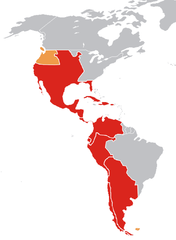
| 描述 | Mapa de la América española a finales del siglo XVIII / Map of Spanish America (XVIII century) |
| 日期 | |
| 来源 | 自己的作品 |
| 作者 | Jluisrs |
Leyenda
Mapa del es:Imperio Español en América a finales del siglo XVIII en su máxima expansión en ese continente.
- En rojo, los virreinatos y demás colonias.
- En amarillo oscuro, territorios disputados o reclamados por España.
Legend
Map of the w:Spanish Empire in America in the XVIII century.
- In red, Spanish posessions.
- In orange, reclamations and posessions where the Spanish had de jure authority only.
许可协议
| 我,本作品著作权人,释出本作品至公有领域。这适用于全世界。 在一些国家这可能不合法;如果是这样的话,那么: 我无条件地授予任何人以任何目的使用本作品的权利,除非这些条件是法律规定所必需的。 |
文件历史
点击某个日期/时间查看对应时刻的文件。
| 日期/时间 | 缩略图 | 大小 | 用户 | 备注 | |
|---|---|---|---|---|---|
| 当前 | 2007年4月22日 (日) 20:37 | | 749 × 1,022(77 KB) | Jluisrs | {{Information |Description= Mapa de la América española a finales del siglo XVII / Map of Spanish America (XVIII century) |Source=self-made |Date= 22-4-2007 |Author= Jluisrs }} |
文件用途
以下页面使用本文件:
全域文件用途
以下其他wiki使用此文件:
- be.wikipedia.org上的用途
- de.wikipedia.org上的用途
- Spanisches Kolonialreich
- Real Audiencia
- Real Audiencia de Quito
- Vorlage:Navigationsleiste Real Audiencias im Spanischen Kolonialreich
- Real Audiencia von Chile
- Real Audiencia von Charcas
- Real Audiencia von Cuzco
- Real Audiencia von Buenos Aires
- Real Audiencia von Lima
- Real Audiencia von Santa Fe de Bogotá
- Real Audiencia von Caracas
- Real Audiencia von Panama
- Real Audiencia von Mexico
- Real Audiencia von Santo Domingo
- Real Audiencia von Guadalajara
- Real Audiencia von Guatemala
- Real Audiencia von Manila
- en.wikipedia.org上的用途
- es.wikipedia.org上的用途
- fa.wikipedia.org上的用途
- hr.wikipedia.org上的用途
- it.wikipedia.org上的用途
- ka.wikipedia.org上的用途
- lt.wikipedia.org上的用途
- La Platos vicekaralystė
- Naujasis Kuršas
- Amerikos kolonizacija
- Prancūzijos Gviana
- Ispanijos kolonijos Amerikoje
- Akadija
- Moskitų Krantas
- Naujoji Ispanija
- Vinlandas
- Danijos kolonijos Amerikoje
- Anglijos kolonijos Amerikoje
- Prancūzijos kolonijos Amerikoje
- Nyderlandų kolonijos Amerikoje
- Peru vicekaralystė
- Naujoji Prancūzija
- Barbadoso istorija
- Naujosios Granados vicekaralystė
- Naujoji Granados karalystė
- Naujoji Andalūzija
- Ispanijos Vakarų Indijos
- Britų Vest Indija
- Nyderlandų Vakarų Indijos
- Virdžinijos kolonija
- Plimuto kolonija
- Masačusetso įlankos kolonija
- Naujieji Nyderlandai
查看本文件的更多全域用途。
.png)
.png)