File:Sudbury Wanapitei WorldWind.jpg

本预览的尺寸:800 × 600像素。 其他分辨率:320 × 240像素 | 640 × 480像素 | 1,024 × 768像素。
原始文件 (1,024 × 768像素,文件大小:308 KB,MIME类型:image/jpeg)
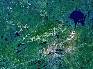
| 描述 | The Sudbury and Wanapitei impact craters in Ontario, Canada. Sudbury is the large, elliptical structure (60 x 30 km); Wanapitei is the lake filled crater at upper right. Its diameter is 8km, its age 37 million years. |
| 来源 | Created with NASA WorldWind by User:Vesta using Landsat 7 (Visible Color) satellite image. |
| 作者 | User:Vesta |
46°36′0″N 81°11′0″W / 46.6°N 81.18333°W
| 本圖像屬於公有領域,因其為NASA的World Wind衛星地圖瀏覽器的一張截圖,且使用了公有領域圖層,如Blue Marble、MODIS、Landsat、SRTM、USGS、GLOBE等。
|
 |
文件历史
点击某个日期/时间查看对应时刻的文件。
| 日期/时间 | 缩略图 | 大小 | 用户 | 备注 | |
|---|---|---|---|---|---|
| 当前 | 2006年1月7日 (六) 09:52 | | 1,024 × 768(308 KB) | Vesta~commonswiki | * '''Description:''' The Sudbury and Wanapitei impact craters in Ontario, Canada. Sudbury is the large, elliptical structure (60 x 30 km), Wanapitei is the lake filled crater at upper right. *'''Source:''' Created with NASA WorldWind by User:Vesta usi |
文件用途
以下3个页面使用本文件:
全域文件用途
以下其他wiki使用此文件:
- af.wikipedia.org上的用途
- ar.wikipedia.org上的用途
- ca.wikipedia.org上的用途
- ceb.wikipedia.org上的用途
- cs.wikipedia.org上的用途
- de.wikipedia.org上的用途
- en.wikipedia.org上的用途
- es.wikipedia.org上的用途
- eu.wikipedia.org上的用途
- fa.wikipedia.org上的用途
- fr.wikipedia.org上的用途
- he.wikipedia.org上的用途
- hu.wikipedia.org上的用途
- id.wikipedia.org上的用途
- it.wikipedia.org上的用途
- ja.wikipedia.org上的用途
- kw.wikipedia.org上的用途
- nl.wikipedia.org上的用途
- ro.wikipedia.org上的用途
- ru.wikipedia.org上的用途
- simple.wikipedia.org上的用途
- sk.wikipedia.org上的用途
- tr.wikipedia.org上的用途
- uk.wikipedia.org上的用途
- uz.wikipedia.org上的用途
- vi.wikipedia.org上的用途
- www.wikidata.org上的用途