File:TY Xangsane 20061001 land.jpg

原始文件(4,000 × 4,000像素,文件大小:1.48 MB,MIME类型:image/jpeg


摘要

描述

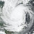
Typhoon Xangsane formed on September 25, 2006, in the western Pacific near the coast of the Philippine Islands. Over the next 36 hours, it grew from a tropical depression (area of low air pressure) to a typhoon. The typhoon crossed the Philippines and was credited for causing 76 deaths there before crossing the South China Sea and coming ashore in central Vietnam on October 1, according to the Agence France-Presse news service. As the storm came ashore in central Vietnam, it packed winds of 148 kilometers per hour (92 miles per hour), causing another six deaths and many injuries. Vietnamese authorities called Typhoon Xangsane the biggest storm to hit the country in several decades.

This photo-like image was acquired by the Moderate Resolution Imaging Spectroradiometer (MODIS) on the Terra satellite on October 1, 2006, at 10:10 a.m. local time (03:10 UTC). Xangsane at the time of this image was a well-defined spiral of clouds, but other typhoon characteristics were not obvious. It lacked a well-defined eye, and the spiral arms of the storm did not have sharp edges or evidence of strong thunderstorms. Much of the initial power of the storm had apparently been sapped as the typhoon came over land.
日期
来源 NASA Earth Observatory Natural Hazards: Typhoon Xangsane
作者 NASA image created by Jesse Allen, Earth Observatory, using data provided courtesy of the MODIS Rapid Response team.
授权
(二次使用本文件)
Public domain 本文件完全由NASA创作,在美国属于公有领域。根据NASA的版权方针,NASA的材料除非另有声明否则不受版权保护。(参见Template:PD-USGov/zhNASA版权方针页面JPL图片使用方针。)
警告:

说明

添加一行文字以描述该文件所表现的内容

此文件中描述的项目

描繪內容

文件历史

点击某个日期/时间查看对应时刻的文件。

日期/时间缩⁠略⁠图大小用户备注
当前2006年10月9日 (一) 15:372006年10月9日 (一) 15:37版本的缩略图4,000 × 4,000(1.48 MB)Nilfanionfix progressive jpg (right file this time..)
2006年10月8日 (日) 05:502006年10月8日 (日) 05:50版本的缩略图4,000 × 4,000(2.98 MB)Coredesat{{Information |Description=NASA MODIS image of Typhoon Xangsane shortly after landfall in Vietnam on October 1, 2006. |Source=[http://earthobservatory.nasa.gov/NaturalHazards/natural_hazards_v2.php3?img_id=13913 NASA Earth Observatory Natural Hazards: Typ

没有页面链接到本图像。

全域文件用途

以下其他wiki使用此文件:

元数据