File:Temburong mukims.png
此为最大尺寸。
Temburong_mukims.png (696 × 565像素,文件大小:57 KB,MIME类型:image/png)
摘要
| 描述 |
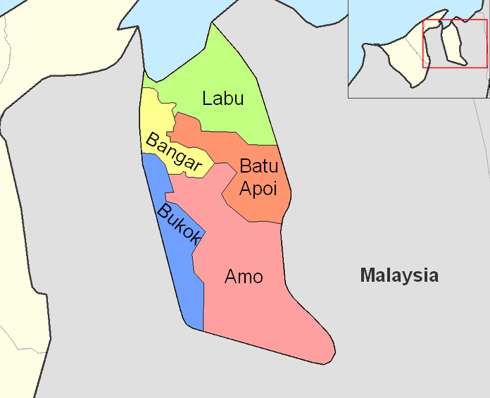
English: Map of the mukims (subdivisions) of the Temburong District of Brunei, in the northwest of the island of Borneo.
Created by Rarelibra 21:37, 11 September 2006 (UTC) for public domain use, using MapInfo Professional v8.5 and various mapping resources. |
| 日期 | 2006年9月11日 (原始上传日期) |
| 来源 | 本檔案是由Xfigpower從en.wikipedia轉移到維基共享資源。 |
| 作者 | 英语维基百科的Rarelibra |
许可协议
| 本作品已被作者英语维基百科的Rarelibra释出到公有领域。这适用于全世界。 在一些国家这可能不合法;如果是这样的话,那么: Rarelibra无条件地授予任何人以任何目的使用本作品的权利,除非这些条件是法律规定所必需的。 |
原始上传日志
原始描述頁面位於這裡。下列使用者名稱均來自en.wikipedia。
- 2006-09-11 21:37 Rarelibra 1056×816×8 (19331 bytes) Map of the mukims of Temburong district of Brunei. Created by ~~~~ for public domain use, using MapInfo Professional v8.5 and various mapping resources.
文件历史
点击某个日期/时间查看对应时刻的文件。
| 日期/时间 | 缩略图 | 大小 | 用户 | 备注 | |
|---|---|---|---|---|---|
| 当前 | 2011年2月27日 (日) 08:59 | | 696 × 565(57 KB) | Naturals | color + change size and type of font |
| 2008年7月3日 (四) 13:27 |  | 1,056 × 816(19 KB) | Xfigpower | {{Information |Description={{en|Map of the mukims of Temburong district of Brunei. Created by Rarelibra 21:37, 11 September 2006 (UTC) for public domain use, using MapInfo Professional v8.5 and various mapping resources.}} |Source=T |
文件用途
以下页面使用本文件:
全域文件用途
以下其他wiki使用此文件:
- de.wikipedia.org上的用途
- en.wikipedia.org上的用途
- es.wikipedia.org上的用途
- fa.wikipedia.org上的用途
- frr.wikipedia.org上的用途
- fr.wikipedia.org上的用途
- hu.wikipedia.org上的用途
- id.wikipedia.org上的用途
- it.wikipedia.org上的用途
- ja.wikipedia.org上的用途
- ko.wikipedia.org上的用途
- lt.wikipedia.org上的用途
- nl.wikipedia.org上的用途
- no.wikipedia.org上的用途
- pl.wikipedia.org上的用途
查看本文件的更多全域用途。