File:The Southern Milky Way Above ALMA.jpg

原始文件 (5,315 × 3,544像素,文件大小:6.51 MB,MIME类型:image/jpeg)
摘要
| 描述 |
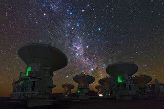
English: ESO Photo Ambassador Babak Tafreshi snapped this remarkable image of the antennas of the Atacama Large Millimeter/submillimeter Array (ALMA), set against the splendour of the Milky Way. The richness of the sky in this picture attests to the unsurpassed conditions for astronomy on the 5000-metre-high Chajnantor plateau in Chile’s Atacama region.
This view shows the constellations of Carina (The Keel) and Vela (The Sails). The dark, wispy dust clouds of the Milky Way streak from middle top left to middle bottom right. The bright orange star in the upper left is Suhail in Vela, while the similarly orange star in the upper middle is Avior, in Carina. Of the three bright blue stars that form an “L” near these stars, the left two belong to Vela, and the right one to Carina. And exactly in the centre of the image below these stars gleams the pink glow of the Carina Nebula (eso1208). ESO, the European partner in ALMA, is providing 25 of the 66 antennas that will make up the completed telescope. The two antennas closest to the camera, on which the careful viewer can find the markings “DA-43” and “DA-41”, are examples of these European antennas. Construction of the full ALMA array will be completed in 2013, but the telescope is already making scientific observations with a partial array of antennas. Babak Tafreshi is founder of The World At Night, a programme to create and exhibit a collection of stunning photographs and time-lapse videos of the world’s most beautiful and historic sites against a night-time backdrop of stars, planets and celestial events. ALMA, an international astronomy facility, is a partnership of Europe, North America and East Asia in cooperation with the Republic of Chile. ALMA construction and operations are led on behalf of Europe by ESO, on behalf of North America by the National Radio Astronomy Observatory (NRAO), and on behalf of East Asia by the National Astronomical Observatory of Japan (NAOJ). The Joint ALMA Observatory (JAO) provides the unified leadership and management of the construction, commissioning and operation of ALMA. |
| 日期 | (released) |
| 来源 | http://www.eso.org/public/images/potw1222a/ |
| 作者 | ESO/B. Tafreshi/TWAN (twanight.org) |
| 相机位置 | | 在以下服务上查看本图像和附近其他图像: OpenStreetMap |
|---|
许可协议
This media was created by the European Southern Observatory (ESO).
Their website states: "Unless specifically noted, the images, videos, and music distributed on the public ESO website, along with the texts of press releases, announcements, pictures of the week, blog posts and captions, are licensed under a Creative Commons Attribution 4.0 International License, and may on a non-exclusive basis be reproduced without fee provided the credit is clear and visible." To the uploader: You must provide a link (URL) to the original file and the authorship information if available. | |
文件历史
点击某个日期/时间查看对应时刻的文件。
| 日期/时间 | 缩略图 | 大小 | 用户 | 备注 | |
|---|---|---|---|---|---|
| 当前 | 2012年10月14日 (日) 17:24 | | 5,315 × 3,544(6.51 MB) | Stas1995 | |
| 2012年10月14日 (日) 17:22 |  | 4,000 × 2,667(5.78 MB) | Stas1995 | ||
| 2012年5月29日 (二) 15:31 |  | 1,280 × 853(264 KB) | Jmencisom |
文件用途
以下2个页面使用本文件:
全域文件用途
以下其他wiki使用此文件:
- en.wikipedia.org上的用途
- en.wikiversity.org上的用途
- hu.wikipedia.org上的用途
- it.wikipedia.org上的用途
- lb.wikipedia.org上的用途
- ms.wikipedia.org上的用途
- pt.wikipedia.org上的用途
- sr.wikipedia.org上的用途