File:Tide legal use.gif
此为最大尺寸。
Tide_legal_use.gif (720 × 477像素,文件大小:31 KB,MIME类型:image/gif)
摘要
| 描述 |
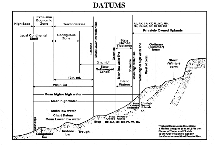
English: The principal tidal data related to a beach profile. The intersection of the tidal datum with land determines the landward edge of a marine boundary. |
| 来源 |
From NOS Tidal Datums Pub (on Naval Postgraduate School). http://www.oc.nps.navy.mil/nom/day1/partc.html figure:a http://www.oc.nps.navy.mil/nom/day1/tidal_datums_fig17.gif |
| 作者 |
许可协议
 | ||
| 本文件已被确认为免除已知的著作权法限制(包括所有相关权利)。 | ||
原始上传日志
本檔案是使用For the Common Good,從en.wikipedia轉移到維基共享資源。
原始描述頁面位於這裡。下列使用者名稱均來自en.wikipedia。
| 日期/时间 | 大小 | 用户 | 备注 |
|---|---|---|---|
| 00:41, 12 April 2007 | 720 × 477 (31,829 bytes) | w:en:Rmo13 (留言 | 贡献) | page: The principal tidal datums related to a beach profile. The intersection of the tidal datum with land determines the landward edge of a marine boundary. From NOS Tidal Datums Pub (on Naval Postgraduate School). http://www.oc.nps.navy.mil/nom/day1/par |
文件历史
点击某个日期/时间查看对应时刻的文件。
| 日期/时间 | 缩略图 | 大小 | 用户 | 备注 | |
|---|---|---|---|---|---|
| 当前 | 2016年11月20日 (日) 16:16 | | 720 × 477(31 KB) | Mcapdevila | Transferred from en.wikipedia: see original upload log above |
文件用途
以下页面使用本文件:
全域文件用途
以下其他wiki使用此文件:
- ca.wikipedia.org上的用途
- cs.wikipedia.org上的用途
- en.wikipedia.org上的用途
- fa.wikipedia.org上的用途
- fr.wikipedia.org上的用途
- vi.wikipedia.org上的用途