File:Topographic map of the Ciskei.svg

此SVG文件的PNG预览的大小:484 × 599像素。 其他分辨率:194 × 240像素 | 388 × 480像素 | 620 × 768像素 | 827 × 1,024像素 | 1,654 × 2,048像素 | 492 × 609像素。
原始文件 (SVG文件,尺寸为492 × 609像素,文件大小:807 KB)
摘要
| 描述 |
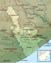
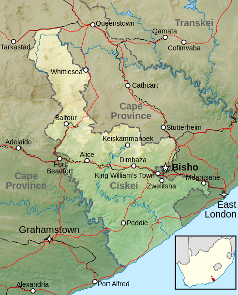
Afrikaans: Topografiese kaart van die voormalige Ciskei-tuisland wat vanaf 1981 tot 1994 nominaal onafhanklik van Suid-Afrika was. Aangedui is die terrein, groter riviere, hoofpaaie, spoorweë en hoofsentra.
English: Topographic map of the Ciskei, a former bantustan that was nominally independent of South Africa from 1981 to 1994. Included are terrain, major rivers, main roads, railways and main towns. |
|||
| 日期 | ||||
| 来源 |
|
|||
| 作者 | Htonl | |||
| 授权 (二次使用本文件) |
本文件采用知识共享署名-相同方式共享 3.0 未本地化版本许可协议授权。
|
文件历史
点击某个日期/时间查看对应时刻的文件。
| 日期/时间 | 缩略图 | 大小 | 用户 | 备注 | |
|---|---|---|---|---|---|
| 当前 | 2013年4月5日 (五) 22:04 | | 492 × 609(807 KB) | Htonl | labels |
| 2013年4月5日 (五) 11:36 |  | 492 × 609(824 KB) | Htonl | {{Information |Description ={{en|1=Topographic map of the w:Ciskei, a former bantustan that was nominally independent of South Africa. Includes terrain, major rivers, main roads, railways and main towns.}} |So... |
文件用途
以下页面使用本文件:
全域文件用途
以下其他wiki使用此文件:
- af.wikipedia.org上的用途
- de.wikipedia.org上的用途
- en.wikipedia.org上的用途
- es.wikipedia.org上的用途
- frr.wikipedia.org上的用途
- he.wikipedia.org上的用途
- nl.wikipedia.org上的用途
- pl.wikipedia.org上的用途