File:Tropical Storm Hanna (2002).jpg
此为最大尺寸。
Tropical_Storm_Hanna_(2002).jpg (642 × 482像素,文件大小:53 KB,MIME类型:image/jpeg)
.jpg?uselang=zh)
.jpg?uselang=zh)
.jpg?action=history&uselang=zh)
.jpg)
摘要
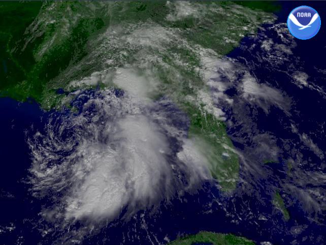
| 描述 | The National Weather Service's Tropical Prediction Center shows Tropical Storm Hanna 105 miles south-southwest of the mouth of the Mississippi River. Winds are sustained at 45 MPH with stronger gusts. | |||
| 日期 | ||||
| 来源 | http://www.nnvl.noaa.gov/cgi-bin/index.cgi?page=items&ser=104823 | |||
| 作者 | NOAA / Satellite and Information Service | |||
| 授权 (二次使用本文件) |
|
文件历史
点击某个日期/时间查看对应时刻的文件。
| 日期/时间 | 缩略图 | 大小 | 用户 | 备注 | |
|---|---|---|---|---|---|
| 当前 | 2006年11月12日 (日) 18:28 | | 642 × 482(53 KB) | Good kitty | |
| 2005年12月25日 (日) 13:58 |  | 320 × 240(15 KB) | Hurricanehink | From http://www.nnvl.noaa.gov/cgi-bin/index.cgi?page=items&ser=104823, this image shows Tropical Storm Hanna in the Gulf of Mexico on September 13, 2002. Despite its disorganized nature, Hanna has winds of 45 mph as it moves to the northwest. {{PD-USGov- |
文件用途
以下页面使用本文件:
全域文件用途
以下其他wiki使用此文件:
- en.wikipedia.org上的用途
- id.wikipedia.org上的用途
- simple.wikipedia.org上的用途
.jpg)