File:Tycho Crater Panorama.jpg
Tycho_Crater_Panorama.jpg (625 × 480像素,文件大小:97 KB,MIME类型:image/jpeg)
摘要
| 描述 |
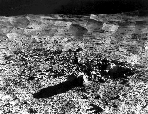
原始说明文字: " Photomosaic of lunar panorama near the Tycho crater taken by Surveyor 7. The hills on the center horizon are about eight miles away from the spacecraft. "Since the landing site survey for the Apollo missions had been successfully completed by the previous Surveyors, the landing site for Surveyor 7 was selected more for its scientific interest. Surveyor 7, in addition to taking thousands of images and gathering a wide variety of surface data, performed star surveys, took pictures of Earth, and tested laser-pointing techniques by detecting laser beams from Earth. |
| 日期 | between 10-Jan-1968 and 26-Jan-1968 |
| 来源 | http://photojournal.jpl.nasa.gov/catalog/PIA02977 |
| 作者 | Courtesy NASA/JPL-Caltech |
| 授权 (二次使用本文件) |
may be used for any purpose without prior permission |
| 月球上的位置 | 在以下服务上查看本图像和附近其他图像: Google地图 |
|---|
许可协议
| 本文件完全由NASA创作,在美国属于公有领域。根据NASA的版权方针,NASA的材料除非另有声明否则不受版权保护。(参见Template:PD-USGov/zh、NASA版权方针页面或JPL图片使用方针。) | ||
 |
警告:
|
文件历史
点击某个日期/时间查看对应时刻的文件。
| 日期/时间 | 缩略图 | 大小 | 用户 | 备注 | |
|---|---|---|---|---|---|
| 当前 | 2006年1月14日 (六) 18:07 | | 625 × 480(97 KB) | W-j-s | == Summary == Original Caption Released with Image taken from [http://photojournal.jpl.nasa.gov/catalog/PIA02977 jpl site]: Photomosaic of lunar panorama near the Tycho crater taken by Surveyor 7. The hills on the center horizon are about |
文件用途
全域文件用途
以下其他wiki使用此文件:
- als.wikipedia.org上的用途
- ar.wikipedia.org上的用途
- ca.wikipedia.org上的用途
- cs.wikipedia.org上的用途
- da.wikipedia.org上的用途
- el.wikipedia.org上的用途
- en.wikipedia.org上的用途
- et.wikipedia.org上的用途
- fr.wikipedia.org上的用途
- hu.wikipedia.org上的用途
- id.wikipedia.org上的用途
- io.wikipedia.org上的用途
- it.wikipedia.org上的用途
- ja.wikipedia.org上的用途
- ms.wikipedia.org上的用途
- nl.wikipedia.org上的用途
- nn.wikipedia.org上的用途
- oc.wikipedia.org上的用途
- pl.wikipedia.org上的用途
- ru.wikipedia.org上的用途
- sr.wikipedia.org上的用途
- sv.wikipedia.org上的用途
- ta.wikipedia.org上的用途
- uk.wikipedia.org上的用途
- vi.wikipedia.org上的用途