File:Typhoon Damrey 09 may 2000 0530Z.jpg

本预览的尺寸:600 × 600像素。 其他分辨率:240 × 240像素 | 480 × 480像素。
原始文件 (800 × 800像素,文件大小:208 KB,MIME类型:image/jpeg)
摘要
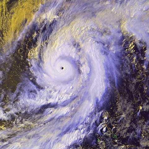
| 描述 | Severe tropical cyclone 01W, Damrey, was located near 16.4N 134.4E moving in a northeasterly direction at 13 knots. Maximum sustained winds were estimated at 130 knots, gusts to 160 knots. | |||
| 日期 | ||||
| 来源 | http://www.osei.noaa.gov/Events/Tropical/W_Pacific/2000/TRCdamrey130_N4.jpg | |||
| 作者 | NOAA / Operational Significant Event Imagery | |||
| 授权 (二次使用本文件) |
|
文件历史
点击某个日期/时间查看对应时刻的文件。
| 日期/时间 | 缩略图 | 大小 | 用户 | 备注 | |
|---|---|---|---|---|---|
| 当前 | 2006年12月12日 (二) 04:13 | | 800 × 800(208 KB) | Good kitty | == Summary == {{Information |Description=Severe tropical cyclone 01W, Damrey, was located near 16.4N 134.4E moving in a northeasterly direction at 13 knots. Maximum sustained winds were estimated at 130 knots, gusts to 160 knots. |Source=http://www.osei.n |
文件用途
全域文件用途
以下其他wiki使用此文件:
- ja.wikipedia.org上的用途
- vi.wikipedia.org上的用途