File:US-Timezones.svg

此SVG文件的PNG预览的大小:776 × 599像素。 其他分辨率:311 × 240像素 | 622 × 480像素 | 995 × 768像素 | 1,280 × 988像素 | 2,560 × 1,977像素 | 1,238 × 956像素。
原始文件 (SVG文件,尺寸为1,238 × 956像素,文件大小:7.19 MB)
摘要
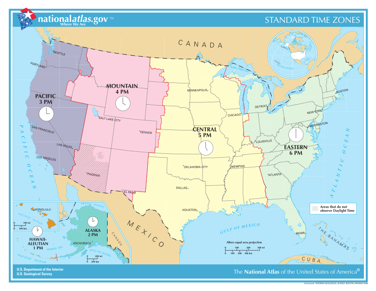
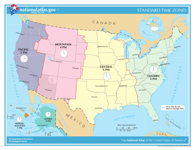
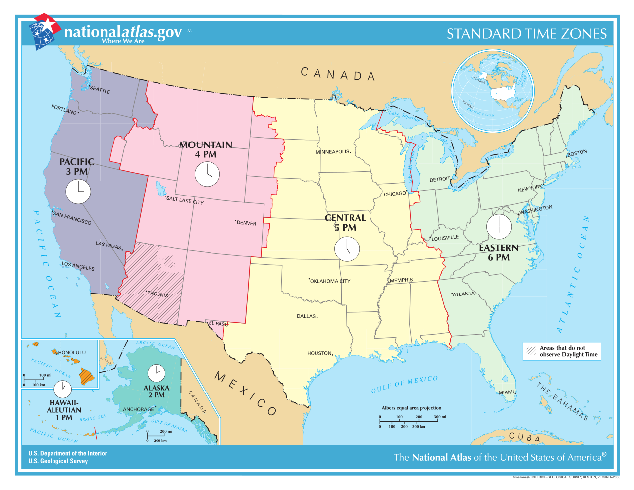
| 描述 | A map of the time zones of the United States; converted from a PDF file. |
| 日期 | |
| 来源 | http://nationalatlas.gov/printable/images/pdf/reference/timezones4.pdf, from http://nationalatlas.gov/printable/timezones.html |
| 作者 | NationalAtlas.gov; uploaded by User:RaviC |
| 其他版本 |
此文件衍生的作品: US-Timezones-as.svg Image:TimeZonesUSA.png, Image:National-atlas-timezones-2006.gif |
许可协议
本地圖取自美國國家地圖集的某個版本。國家地圖集的絕大多數作品是美國聯邦政府的作品,因此屬於公有領域。
連結網址︰ NationalAtlas.gov | 1970年印刷版︰ 國會檔案館, Perry-Castañeda圖書館
|
文件历史
点击某个日期/时间查看对应时刻的文件。
| 日期/时间 | 缩略图 | 大小 | 用户 | 备注 | |
|---|---|---|---|---|---|
| 当前 | 2013年7月29日 (一) 18:08 | | 1,238 × 956(7.19 MB) | Alejandroadan | Putting the current (July 29, 2013) version of the image to update the old one (although from what I've seen they look the same). |
| 2008年10月17日 (五) 20:45 |  | 792 × 612(5.62 MB) | RaviC | {{Information |Description=A map of the time zones of the United States; converted from [http://nationalatlas.gov/printable/images/pdf/reference/timezones4.pdf a PDF file]. |Source=http://nationalatlas.gov/printable/ima |
文件用途
全域文件用途
以下其他wiki使用此文件:
- ar.wikipedia.org上的用途
- da.wikipedia.org上的用途
- de.wikipedia.org上的用途
- en.wikipedia.org上的用途
- en.wikivoyage.org上的用途
- es.wikipedia.org上的用途
- fa.wikipedia.org上的用途
- fr.wikipedia.org上的用途
- Wikipédia:Statistiques des anecdotes de la page d'accueil/Visibilité des anecdotes (2017)
- Heure aux États-Unis
- Discussion:Heure aux États-Unis
- Wikipédia:Statistiques des anecdotes de la page d'accueil/Visibilité des anecdotes (2017)/2017 11
- Projet:Aide et accueil/Twitter/Tweets/archives/novembre 2017
- Wikipédia:Le saviez-vous ?/Archives/2017
- Liste des régions des États-Unis
- fr.wikivoyage.org上的用途
- fy.wikipedia.org上的用途
- hi.wikivoyage.org上的用途
- ja.wikipedia.org上的用途
- lt.wikipedia.org上的用途
- no.wikipedia.org上的用途
- ro.wikipedia.org上的用途
- ru.wikipedia.org上的用途
- simple.wikipedia.org上的用途
- sl.wikipedia.org上的用途
- sv.wikipedia.org上的用途
- tr.wikipedia.org上的用途
- uk.wikipedia.org上的用途
- ur.wikipedia.org上的用途
- uz.wikipedia.org上的用途
- vi.wikipedia.org上的用途
- www.wikidata.org上的用途