File:Vendée department location map.svg

此SVG文件的PNG预览的大小:800 × 525像素。 其他分辨率:320 × 210像素 | 640 × 420像素 | 1,024 × 672像素 | 1,280 × 839像素 | 2,560 × 1,679像素 | 1,386 × 909像素。
原始文件 (SVG文件,尺寸为1,386 × 909像素,文件大小:336 KB)
摘要
| 描述 |
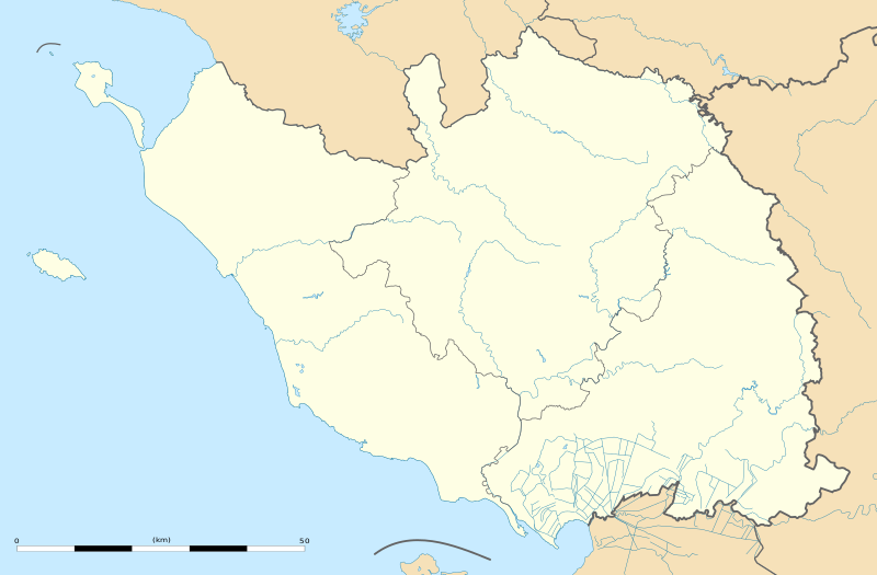
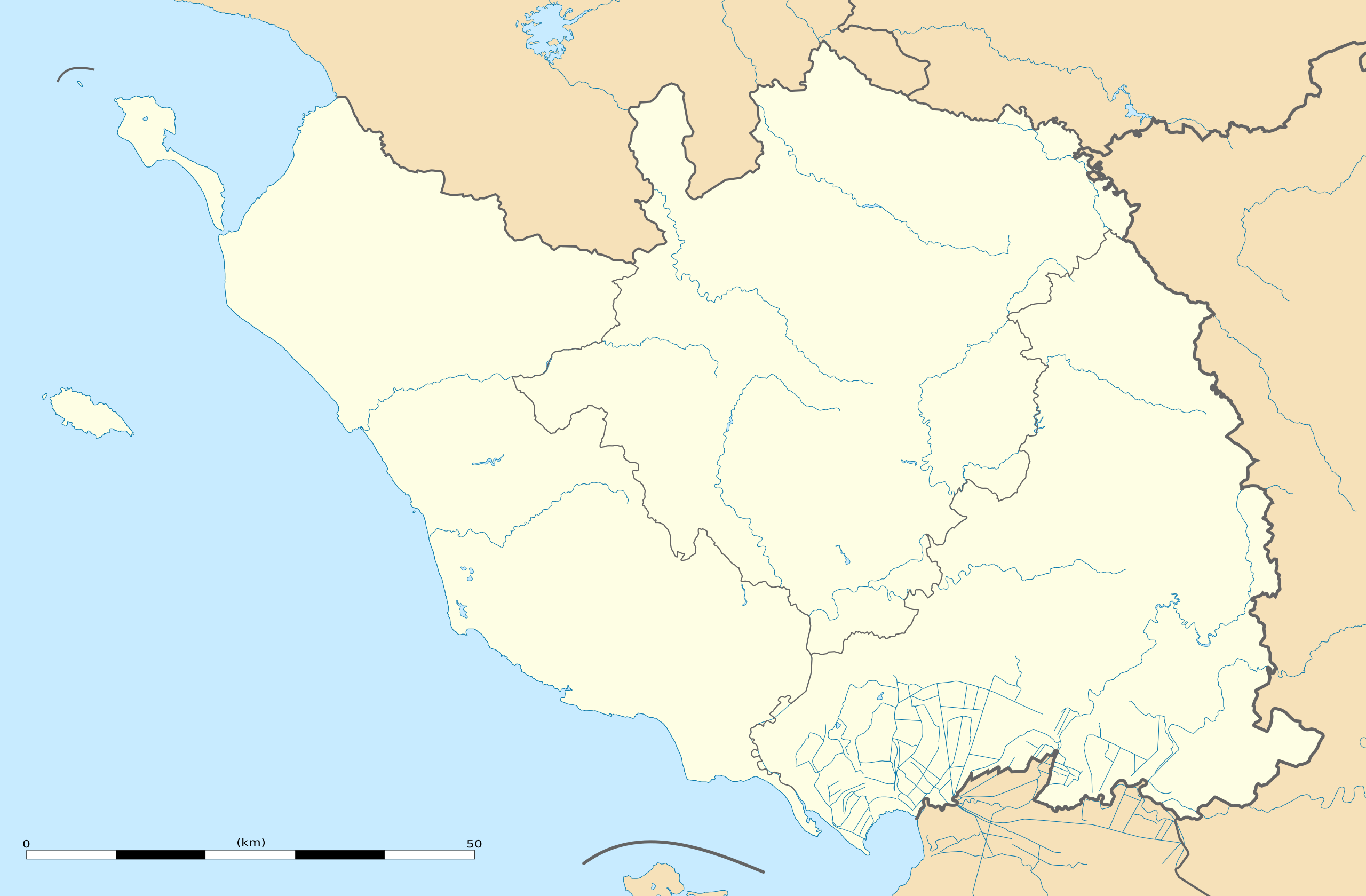
English: Blank administrative map of the department of Vendée, France, as in February 2011, for geo-location purpose, with distinct boundaries for regions, departments and arrondissements.
Français : Carte administrative vierge du département de la Vendée, France, telle qu'en février 2011, destinée à la géolocalisation, avec limite distincte des régions, départements et arrondissements. Estimated scale: 1:440,000 (precision: 110 m)
Geographic limits of the map:
|
||
| 日期 | |||
| 来源 |
自己的作品
|
||
| 作者 | Eric Gaba (Sting - fr:Sting) | ||
| 授权 (二次使用本文件) |
|
||
| 其他版本 |
|

| 相机位置 | | 在以下服务上查看本图像和附近其他图像: OpenStreetMap |
|---|
许可协议
Eric Gaba, Wikimedia Commons user Sting,本作品著作权人,特此采用以下许可协议发表本作品:
本文件采用知识共享署名-相同方式共享 3.0 未本地化版本许可协议授权。
署名: Eric Gaba, Wikimedia Commons user Sting
- 您可以自由地:
- 共享 – 复制、发行并传播本作品
- 修改 – 改编作品
- 惟须遵守下列条件:
- 署名 – 您必须对作品进行署名,提供授权条款的链接,并说明是否对原始内容进行了更改。您可以用任何合理的方式来署名,但不得以任何方式表明许可人认可您或您的使用。
- 相同方式共享 – 如果您再混合、转换或者基于本作品进行创作,您必须以与原先许可协议相同或相兼容的许可协议分发您贡献的作品。
文件历史
点击某个日期/时间查看对应时刻的文件。
| 日期/时间 | 缩略图 | 大小 | 用户 | 备注 | |
|---|---|---|---|---|---|
| 当前 | 2011年3月2日 (三) 21:45 | | 1,386 × 909(336 KB) | Sting | == {{int:filedesc}} == {{Information |Description={{en|Blank administrative map of the department of Vendée, France, as in February 2011, for geo-location purpose, with distinct boundaries for regions, departments and arrondissements.}} { |
文件用途
超过100个页面使用本文件。 下面的列表只显示使用本文件的前100个页面。完整列表可用。
- 内米
- 努瓦尔穆捷昂利勒
- 勒塔布利耶
- 勒尚圣佩尔
- 勒布佩尔
- 勒马佐
- 卢瓦
- 圣于尔班 (旺代省)
- 圣佩克西娜
- 圣保罗昂帕雷
- 圣保罗蒙珀尼
- 圣叙尔皮斯-勒韦尔东
- 圣叙尔皮斯昂帕雷
- 圣埃米娜
- 圣塞西尔
- 圣富瓦
- 圣弗洛朗斯
- 圣弗莱沃代卢
- 圣拉代贡德代努瓦耶
- 圣普鲁昂
- 圣樊尚叙雅尔
- 圣樊尚斯泰尔朗日
- 圣热姆拉普莱讷
- 圣皮埃尔迪舍曼
- 圣米歇尔勒克卢克
- 圣米歇尔昂莱尔姆
- 圣米歇尔蒙梅屈尔
- 圣菲尔贝德布艾讷
- 圣西吉斯蒙 (旺代省)
- 圣雷韦朗
- 塞夫尔河畔莫尔塔涅
- 塞里涅
- 尚布勒托
- 尚帕涅莱马赖
- 尚托奈
- 尼约勒勒多朗
- 山地圣母镇
- 布勒伊巴雷
- 布安
- 布尔讷佐
- 布尔诺 (旺代省)
- 布洛涅 (旺代省)
- 布瓦德瑟内
- 布耶-库尔多
- 布费雷
- 拉卡耶尔-圣伊莱尔
- 拉布勒托尼耶尔-拉克莱
- 拉布吕菲耶尔
- 拉布瓦西耶尔德朗德
- 拉布瓦西耶尔德蒙泰居
- 拉梅拉蒂耶尔
- 拉梅耶赖蒂耶
- 拉沙佩勒埃尔米耶
- 拉沙佩勒帕吕欧
- 拉沙佩勒欧利斯
- 拉沙佩勒泰梅尔
- 拉沙佩勒阿沙尔
- 拉莫特阿沙尔
- 拉谢兹勒维孔特
- 拉谢兹日罗
- 拉贝尔纳迪耶尔
- 旧圣皮埃尔
- 格拉翁河畔圣樊尚
- 梅尔旺 (旺代省)
- 梅纳尔拉巴罗蒂耶尔
- 欧蒂兹河畔尼约勒
- 沙奈 (旺代省)
- 沙朗
- 沙耶苏莱索尔莫
- 沙耶莱马赖
- 滨海奥洛讷
- 滨海布雷姆
- 滨海布雷蒂尼奥勒
- 瑟宰
- 穆尚 (旺代省)
- 穆捷莱莫费
- 穆泽伊-圣马丹
- 穆耶龙勒卡普蒂夫
- 穆耶龙昂帕雷
- 纳利耶
- 苏朗
- 莫尔迈松
- 莫雷耶
- 莱布鲁济勒
- 莱河畔穆捷
- 莱河畔马勒伊-迪赛
- 萨莱尔泰讷
- 蒙图尔奈
- 蒙泰居
- 蒙特勒伊 (旺代省)
- 蒙西雷涅
- 谢村
- 贝赛 (旺代省)
- 里耶圣母镇
- 锡古尔奈
- 马列夫尔
- 马尔蒂内
- 马尔赛-圣拉德贡德
- 马耶 (旺代省)
- 马耶宰
查看连接到这个文件的更多链接。
全域文件用途
以下其他wiki使用此文件:
- als.wikipedia.org上的用途
- de.wikipedia.org上的用途
- eo.wikipedia.org上的用途
- Les Sables-d'Olonne
- Ŝablono:Situo sur mapo Francio Vendée
- L'Aiguillon-sur-Mer
- Fontenay-le-Comte
- Sainte-Radégonde-des-Noyers
- Puyravault (Vendée)
- Saint-Michel-en-l'Herm
- Champagné-les-Marais
- Triaize
- Longeville-sur-Mer
- Noirmoutier-en-l'Île
- La Roche-sur-Yon (stacidomo)
- Chantonnay
- Île-d'Yeu
- Montaigu (stacidomo)
- Montaigu (Vendée)
- Montaigu-Vendée
- Les Sables-d'Olonne (stacidomo)
- Saint-Hilaire-de-Riez (stacidomo)
- Saint-Hilaire-de-Riez
- Saint-Gilles-Croix-de-Vie (stacidomo)
- Saint-Gilles-Croix-de-Vie
- Challans (stacidomo)
- La Chaize-le-Vicomte (stacidomo)
- La Chaize-le-Vicomte
- L'Herbergement - Les Brouzils (stacidomo)
- L'Herbergement
- Les Brouzils
- Luçon (stacidomo)
- Chantonnay (stacidomo)
- Olonne-sur-Mer (stacidomo)
- Olonne-sur-Mer
- Belleville-Vendée (stacidomo)
- Bellevigny
- Belleville-sur-Vie
- Bournezeau (stacidomo)
- Bournezeau
- Cugand (stacidomo)
- Cugand
- Fougeré (stacidomo)
- Fougeré (Vendée)
- Pouzauges (stacidomo)
- Pouzauges
- La Meilleraie-Tillay
查看本文件的更多全域用途。