File:VenusLanderTopo.jpg
本预览的尺寸:800 × 576像素。 其他分辨率:320 × 230像素 | 640 × 460像素 | 1,024 × 737像素 | 1,280 × 921像素 | 2,560 × 1,842像素 | 3,650 × 2,626像素。
原始文件 (3,650 × 2,626像素,文件大小:4.95 MB,MIME类型:image/jpeg)
摘要
| 描述 | |
| 日期 | |
| 来源 |
Source: A combination of the following Public Domain data sources |
| 作者 | Zamonin |


许可协议
我,本作品著作权人,特此采用以下许可协议发表本作品:
本文件采用知识共享署名-相同方式共享 3.0 未本地化版本许可协议授权。
- 您可以自由地:
- 共享 – 复制、发行并传播本作品
- 修改 – 改编作品
- 惟须遵守下列条件:
- 署名 – 您必须对作品进行署名,提供授权条款的链接,并说明是否对原始内容进行了更改。您可以用任何合理的方式来署名,但不得以任何方式表明许可人认可您或您的使用。
- 相同方式共享 – 如果您再混合、转换或者基于本作品进行创作,您必须以与原先许可协议相同或相兼容的许可协议分发您贡献的作品。
文件历史
点击某个日期/时间查看对应时刻的文件。
| 日期/时间 | 缩略图 | 大小 | 用户 | 备注 | |
|---|---|---|---|---|---|
| 当前 | 2023年9月22日 (五) 12:14 | | 3,650 × 2,626(4.95 MB) | Zamonin | new color scheme |
| 2023年9月22日 (五) 12:13 |  | 3,650 × 2,626(5.05 MB) | Zamonin | new color scheme | |
| 2023年9月7日 (四) 20:35 |  | 3,650 × 2,626(5.08 MB) | Zamonin | new layout | |
| 2020年12月15日 (二) 08:04 |  | 1,900 × 1,250(1.72 MB) | Zamonin | Added Venera 7 | |
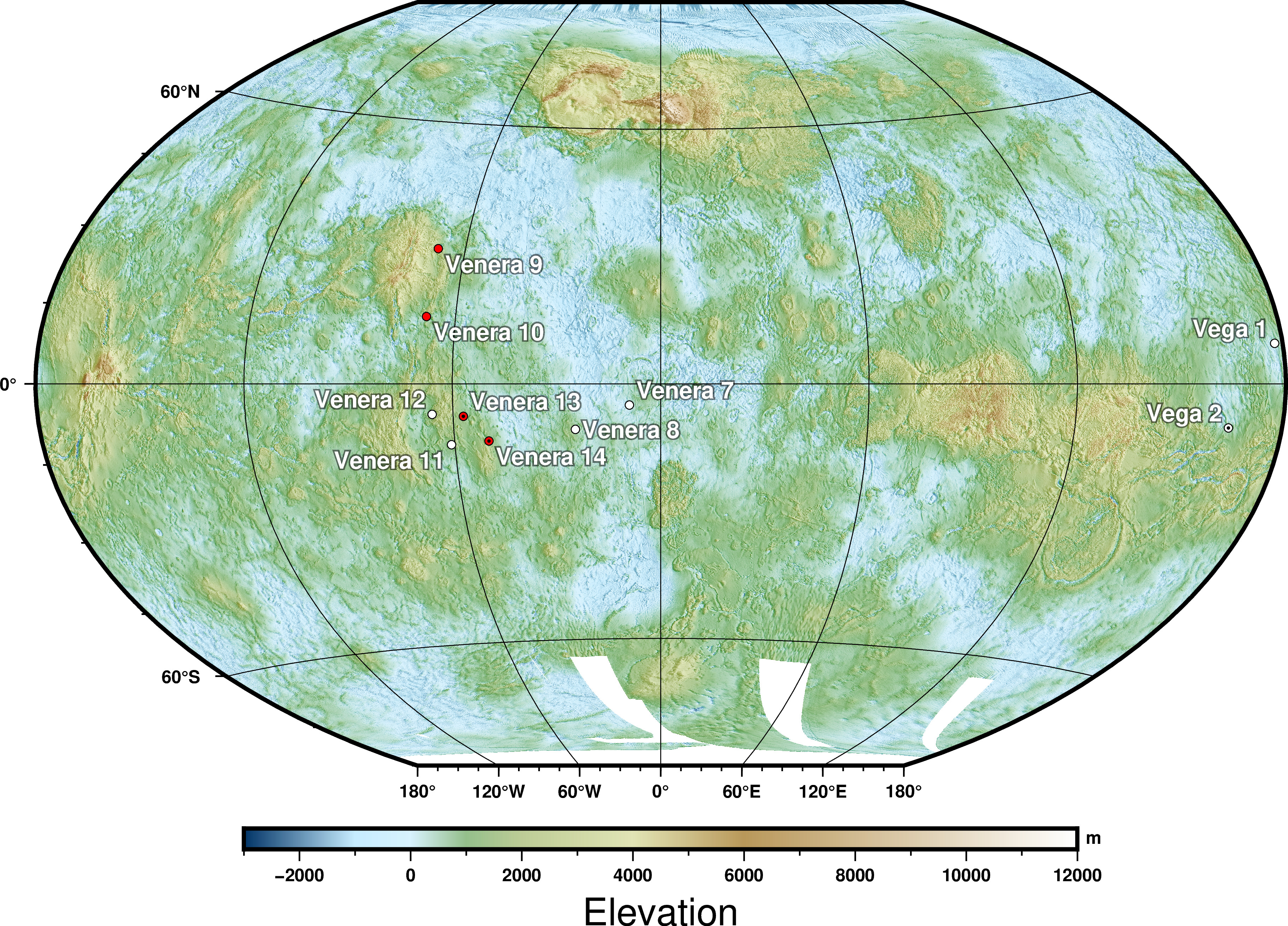
| 2016年8月4日 (四) 20:40 |  | 2,000 × 1,300(2.11 MB) | Zamonin | Added positions of all landers. Red points indicate images taken, black central dots surface samples | |
| 2013年7月31日 (三) 08:59 |  | 1,500 × 1,060(643 KB) | Zamonin | increased resolution of grid | |
| 2013年7月24日 (三) 10:55 |  | 1,500 × 1,060(584 KB) | Zamonin | User created page with UploadWizard |
文件用途
全域文件用途
以下其他wiki使用此文件:
- af.wikipedia.org上的用途
- ar.wikipedia.org上的用途
- bn.wikipedia.org上的用途
- en.wikipedia.org上的用途
- en.wikibooks.org上的用途
- es.wikipedia.org上的用途
- fa.wikipedia.org上的用途
- fi.wikipedia.org上的用途
- fr.wikipedia.org上的用途
- gv.wikipedia.org上的用途
- hu.wikipedia.org上的用途
- hy.wikipedia.org上的用途
- id.wikipedia.org上的用途
- ko.wikipedia.org上的用途
- mk.wikipedia.org上的用途
- mt.wikipedia.org上的用途
- pt.wikipedia.org上的用途
- sr.wikipedia.org上的用途
- tr.wikipedia.org上的用途
- uk.wikipedia.org上的用途
- vi.wikipedia.org上的用途
- www.wikidata.org上的用途