File:Via Egnatia-en.jpg

本预览的尺寸:733 × 600像素。 其他分辨率:293 × 240像素 | 587 × 480像素 | 939 × 768像素 | 1,100 × 900像素。
原始文件 (1,100 × 900像素,文件大小:420 KB,MIME类型:image/jpeg)
摘要
| 描述 |
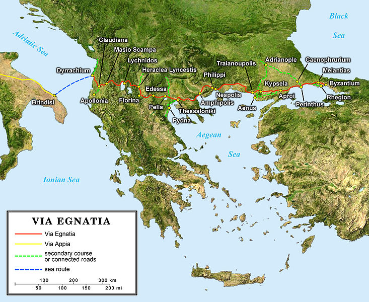
English: English map of the ancient Roman Via Egnatia crossing the South of the Balkans.
Français : Carte en anglais de l'antique Via Egnatia romaine traversant le sud des Balkans.
Deutsch: Englische Karte der Via Egnatia (griechisch Ἐγνατία Ὁδός) eine römische Straße die Adriaküste mit dem Bosporus verband |
||
| 日期 | |||
| 来源 |
Own work; |
||
| 作者 | Eric Gaba (Sting - fr:Sting) | ||
| 授权 (二次使用本文件) |
|
||
| 其他版本 |
[]
|


许可协议
我,本作品著作权人,特此采用以下许可协议发表本作品:
本文件采用知识共享署名-相同方式共享 2.5 通用许可协议授权。
- 您可以自由地:
- 共享 – 复制、发行并传播本作品
- 修改 – 改编作品
- 惟须遵守下列条件:
- 署名 – 您必须对作品进行署名,提供授权条款的链接,并说明是否对原始内容进行了更改。您可以用任何合理的方式来署名,但不得以任何方式表明许可人认可您或您的使用。
- 相同方式共享 – 如果您再混合、转换或者基于本作品进行创作,您必须以与原先许可协议相同或相兼容的许可协议分发您贡献的作品。
文件历史
点击某个日期/时间查看对应时刻的文件。
| 日期/时间 | 缩略图 | 大小 | 用户 | 备注 | |
|---|---|---|---|---|---|
| 当前 | 2006年6月10日 (六) 21:55 | | 1,100 × 900(420 KB) | Sting | {{Information |Description=Map of the antic Roman Via Egnatia crossing the South of the Balkans |Source=''For the source of data and the modern name of the cities, see the'' '''[[|discussion page]]''' |Date= June 2006 |Author= Eric Gab |
文件用途
没有页面链接到本图像。
全域文件用途
以下其他wiki使用此文件:
- ar.wikipedia.org上的用途
- ast.wikipedia.org上的用途
- az.wikipedia.org上的用途
- bg.wikipedia.org上的用途
- ca.wikipedia.org上的用途
- cs.wikipedia.org上的用途
- da.wikipedia.org上的用途
- de.wikipedia.org上的用途
- de.wikivoyage.org上的用途
- el.wikipedia.org上的用途
- en.wikipedia.org上的用途
- en.wikivoyage.org上的用途
- eo.wikipedia.org上的用途
- es.wikipedia.org上的用途
- et.wikipedia.org上的用途
- fa.wikipedia.org上的用途
- fr.wikipedia.org上的用途
- hr.wikipedia.org上的用途
- hu.wikipedia.org上的用途
- hy.wikipedia.org上的用途
查看本文件的更多全域用途。