File:Vilayet of Kosovo (1881–1912) map.png

本预览的尺寸:645 × 599像素。 其他分辨率:258 × 240像素 | 517 × 480像素 | 820 × 762像素。
原始文件 (820 × 762像素,文件大小:74 KB,MIME类型:image/png)
_map.png?uselang=zh)
_map.png?uselang=zh)
_map.png?action=history&uselang=zh)
_map.png)
摘要
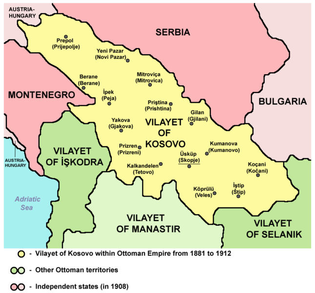
VILAJETI I KOSOVËS NËN PERANDORINË OSMANE NGA 1881 DERI MË 1912
Source and licence

|
This map has been uploaded by Electionworld from en.wikipedia.org to enable the |
| 本作品已被作者PANONIAN释出到公有领域。这适用于全世界。 在一些国家这可能不合法;如果是这样的话,那么: |
References
Main reference:
- Created according to historical map from this book: Petrit Imami, Srbi i Albanci kroz vekove, Beograd, 2000.
Secondary references with similar maps:
- Noel Malcolm, Kosovo - A Short History, Pan Books, London, 2002.
- Školski istorijski atlas, Zavod za izdavanje udžbenika SR Srbije, Beograd, 1970.
- Sve srpske mape - od šestog veka do Pariza, Specijalno izdanje BLICA, Decembar 1995. godine.
- http://terkepek.adatbank.transindex.ro/kepek/netre/95.gif
- http://www.panmacedonian.info/macedonism_thesis_files/Macedonism%20of%20the%20Slavs_img_19.jpg
- http://www.zum.de/whkmla/histatlas/balkans/rumelia1891t.gif
- http://www.kosovo.net/sk/rastko-kosovo/istorija/kosovo_chronicles/kc_figure1.gif
- http://www.hri.org/docs/macque/map3.gif
- http://remmm.revues.org/docannexe/image/305/img-1-small480.png
- http://www.cairn.info/loadimg.php?FILE=GMCC/GMCC_202/GMCC_202_0113/fullGMCC_id9782130527213_pu2001-02d_pa01-da16_art07_img001.jpg
文件历史
点击某个日期/时间查看对应时刻的文件。
| 日期/时间 | 缩略图 | 大小 | 用户 | 备注 | |
|---|---|---|---|---|---|
| 当前 | 2012年9月11日 (二) 13:16 | | 820 × 762(74 KB) | PANONIAN | {{Information |Description ={{en|1=cosmetic changes}} |Source =cosmetic changes |Author =cosmetic changes |Date = |Permission = |other_versions = }} |
| 2011年4月6日 (三) 07:17 |  | 762 × 719(61 KB) | PANONIAN | Reverted to version as of 08:44, 5 April 2011 - trying to solve thumbnail problem | |
| 2011年4月6日 (三) 07:14 |  | 762 × 719(61 KB) | PANONIAN | Reverted to version as of 08:44, 5 April 2011 - trying to solve thumbnail problem | |
| 2011年4月6日 (三) 07:14 |  | 762 × 719(64 KB) | PANONIAN | Reverted to version as of 20:05, 2 June 2009 - trying to solve thumbnail problem | |
| 2011年4月5日 (二) 08:44 |  | 762 × 719(61 KB) | PANONIAN | aesthetical improvement | |
| 2009年6月2日 (二) 20:05 |  | 762 × 719(64 KB) | PANONIAN | ||
| 2006年12月21日 (四) 23:31 |  | 624 × 516(185 KB) | Electionworld | {{ew|en|PANONIAN}} {{PD-user|PANONIAN}} Category:Maps of Kosovo |
文件用途
没有页面链接到本图像。
全域文件用途
以下其他wiki使用此文件:
- af.wikipedia.org上的用途
- ast.wikipedia.org上的用途
- be.wikipedia.org上的用途
- bg.wikipedia.org上的用途
- bn.wikipedia.org上的用途
- br.wikipedia.org上的用途
- bs.wikipedia.org上的用途
- ca.wikipedia.org上的用途
- de.wikipedia.org上的用途
- en.wikipedia.org上的用途
- es.wikipedia.org上的用途
- fi.wikipedia.org上的用途
- fr.wikipedia.org上的用途
- gl.wikipedia.org上的用途
- hr.wikipedia.org上的用途
- ht.wikipedia.org上的用途
- hu.wikipedia.org上的用途
- it.wikipedia.org上的用途
- ja.wikipedia.org上的用途
- lt.wikipedia.org上的用途
- lv.wikipedia.org上的用途
- mk.wikipedia.org上的用途
- nl.wikipedia.org上的用途
- no.wikipedia.org上的用途
- pl.wikipedia.org上的用途
- pt.wikipedia.org上的用途
查看本文件的更多全域用途。
_map.png)
_map.png)