File:W-RSimpleMap.gif

本预览的尺寸:432 × 599像素。 其他分辨率:173 × 240像素 | 346 × 480像素 | 554 × 768像素 | 738 × 1,024像素 | 1,960 × 2,718像素。
原始文件 (1,960 × 2,718像素,文件大小:2.08 MB,MIME类型:image/gif)
摘要
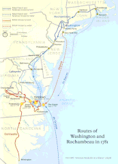
| 描述 | Official National Park Service map of the Washington-Rochambeau Revolutionary Route |
| 日期 | |
| 来源 | http://www.nps.gov/boso/w-r |
| 作者 | National Park Service |
| 授权 (二次使用本文件) |
"The maps at this site are in the public domain. You may use National Park Service maps provided that you agree to assume complete legal responsibility for problems resulting from their use. Although National Park Service maps are easy to modify, understand that modifications can adversely alter the meaning and accuracy of the original data. Law prohibits you from using the National Park Service seal or claiming National Park Service endorsement with downloaded maps." [1] |
许可协议
| 该图片或媒体为美国国家公园管理局雇员在执行公务时创建。作为美国联邦政府的作品,此作品在美国境内属于公有领域。更多信息请参考美国国家公园管理局网站及美国国家公园管理局版权政策。 |

|
此map图片可使用矢量图形重新创建为SVG文件。这具有很多好处;更多信息请参见共享资源:待清理媒体。如果存在此图片的SVG格式,请将其上传,然后将此模板替换为
{{vector version available|新图片名称}}。
建议您将SVG命名为“W-RSimpleMap.svg”,这样在使用Vector version available(或Vva)模板时就不需要填写新图片名称参数。 |
文件历史
点击某个日期/时间查看对应时刻的文件。
| 日期/时间 | 缩略图 | 大小 | 用户 | 备注 | |
|---|---|---|---|---|---|
| 当前 | 2008年4月13日 (日) 19:39 | | 1,960 × 2,718(2.08 MB) | Evrik | == Summary == {{Information |Description = Official National Park Service map of the Washington-Rochambeau Revolutionary Route |Source = [http://www.nps.gov/boso/w-r] |Date = |
文件用途
全域文件用途
以下其他wiki使用此文件:
- ca.wikipedia.org上的用途
- el.wikipedia.org上的用途
- en.wikipedia.org上的用途
- Newport, Rhode Island
- Siege of Yorktown
- Jean-Baptiste Donatien de Vimeur, comte de Rochambeau
- James Manning (minister)
- France in the American Revolutionary War
- Yorktown campaign
- Washington–Rochambeau Revolutionary Route
- March Route of Rochambeau's Army: Scotland Road
- Fourth Camp of Rochambeau's Army
- March Route of Rochambeau's Army: Manship Road-Barstow Road
- March Route of Rochambeau's Army: Palmer Road
- March Route of Rochambeau's Army: Plainfield Pike
- March Route of Rochambeau's Army: Bailey Road
- March Route of Rochambeau's Army: Reservoir Road
- March Route of Rochambeau's Army: Ridgebury Road
- List of historic sites preserved along Rochambeau's route
- User:Ile da france b17/sandbox
- en.wikivoyage.org上的用途
- es.wikipedia.org上的用途
- fa.wikipedia.org上的用途
- fr.wikipedia.org上的用途
- it.wikipedia.org上的用途
- ja.wikipedia.org上的用途
- ko.wikipedia.org上的用途
- pt.wikipedia.org上的用途
- ru.wikipedia.org上的用途
- www.wikidata.org上的用途