File:World in 900 CE.png

本预览的尺寸:800 × 407像素。 其他分辨率:320 × 163像素 | 640 × 326像素 | 1,024 × 521像素 | 1,280 × 652像素 | 4,000 × 2,036像素。
原始文件 (4,000 × 2,036像素,文件大小:1.76 MB,MIME类型:image/png)
摘要
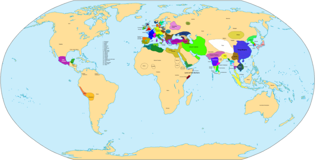
| 描述 | Map of the world in 900 AD. |
| 来源 | 自己的作品 |
| 作者 | Javierfv1212 |

|
此historical map图片可使用矢量图形重新创建为SVG文件。这具有很多好处;更多信息请参见共享资源:待清理媒体。如果存在此图片的SVG格式,请将其上传,然后将此模板替换为
{{vector version available|新图片名称}}。
建议您将SVG命名为“World in 900 CE.svg”,这样在使用Vector version available(或Vva)模板时就不需要填写新图片名称参数。 |
| Maps of world history | |
| BC | |
|
| |
| AD |
1 · 50 · 100 · 200 · 250 · 300 · 400 · 500 · 700 · 750 · 820 · 900 · 1200 · 1500 · 1556 · 1648 · 1700 · 1750 · 1815 · 1859 · 1871 · 1914 · 1935 · 1954 · 1989 · 2000 · |
|
Maps of colonization history | |
|
see also: Eastern Hemisphere only maps template (1300BC-1500AD) | |
| (this template: · view · discuss ) | |
.jpg)
._LOC_2001620596.jpg)
许可协议
| 我,本作品著作权人,释出本作品至公有领域。这适用于全世界。 在一些国家这可能不合法;如果是这样的话,那么: 我无条件地授予任何人以任何目的使用本作品的权利,除非这些条件是法律规定所必需的。 |
文件历史
点击某个日期/时间查看对应时刻的文件。
| 日期/时间 | 缩略图 | 大小 | 用户 | 备注 | |
|---|---|---|---|---|---|
| 当前 | 2021年4月3日 (六) 09:32 | | 4,000 × 2,036(1.76 MB) | Glennznl | Reverted to version as of 23:14, 31 October 2020 (UTC) Completely unsourced, the Igorot society article has been deleted from Wikipedia as it is a hoax |
| 2021年3月27日 (六) 02:54 |  | 4,000 × 2,036(1.57 MB) | Enola gay0 | Reverted to version as of 09:48, 29 May 2019 (UTC) tondo-LCI | |
| 2020年10月31日 (六) 23:14 |  | 4,000 × 2,036(1.76 MB) | Glennznl | Reverted to version as of 18:02, 5 July 2015 (UTC) | |
| 2019年5月29日 (三) 09:48 |  | 4,000 × 2,036(1.57 MB) | Enola gay0 | ||
| 2017年12月7日 (四) 05:20 |  | 4,000 × 2,036(1.76 MB) | Gunkarta | Reverted to version as of 18:02, 5 July 2015 (UTC) false pseudohistory | |
| 2017年6月2日 (五) 12:39 |  | 4,000 × 2,036(1.57 MB) | Theseeker2016 | Tondo, Tundun or Lusung <ref>{{cite book|author=Keat Gin Ooi|title=Southeast Asia: A Historical Encyclopedia, from Angkor Wat to East Timor|url=https://books.google.com/books?id=QKgraWbb7yoC|year=2004|publisher=ABC-CLIO|isbn=978-1-57607-770-2|page=[htt... | |
| 2015年7月5日 (日) 18:02 |  | 4,000 × 2,036(1.76 MB) | BartekChom | Veleti and Czechs did not live on territory of modern Poland, for example File:Europe around 900.jpg | |
| 2013年1月10日 (四) 15:47 |  | 4,000 × 2,036(1.95 MB) | Runehelmet | Updated | |
| 2009年3月20日 (五) 17:20 |  | 4,000 × 2,036(1.79 MB) | Huhsunqu | wari instead moche | |
| 2007年11月4日 (日) 01:50 |  | 4,000 × 2,036(1.8 MB) | Javierfv1212 | {{Information |Description= |Source=self-made |Date= |Author= Javierfv1212 |Permission= |other_versions= }} Category:Maps of the world showing history |
文件用途
以下页面使用本文件:
全域文件用途
以下其他wiki使用此文件:
- bs.wikipedia.org上的用途
- de.wikipedia.org上的用途
- el.wikipedia.org上的用途
- en.wikipedia.org上的用途
- es.wikipedia.org上的用途
- fr.wikipedia.org上的用途
- he.wikipedia.org上的用途
- ka.wikipedia.org上的用途
- lt.wikipedia.org上的用途
- nl.wikipedia.org上的用途
- ru.wikipedia.org上的用途
- sv.wikipedia.org上的用途
- tt.wikipedia.org上的用途
- uk.wikipedia.org上的用途