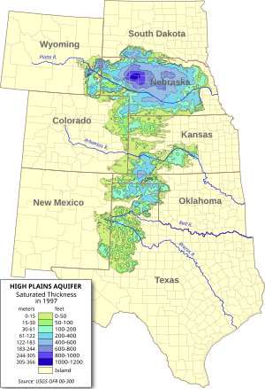
奥加拉拉蓄水层
奥加拉拉蓄水层(英語:Ogallala Aquifer)是位于美国大平原下的一个被沙子、淤泥、粘土和砾石包围的浅水地下含水层。该蓄水层横跨美国八个州(南达科他州、内布拉斯加州、怀俄明州、科罗拉多州、堪萨斯州、俄克拉荷马州、新墨西哥州和德克萨斯州),面积约为174,000 sq mi(450,000 km2),是全球最大的含水层。[1]该蓄水层是地理学家纳尔逊·霍雷肖·达顿于1898年以内布拉斯加州市镇奥加拉拉命名的,为高原含水层,位于奥加拉拉地质组,其中80%的的地区属于高原地带。[2][3]
第二次世界大战之后,由于中心枢轴灌溉以及自动钻井技术的提升,奥加拉拉蓄水层的地下水得以大量开发用于农业生产。[4]时至今日,全美大约27%的耕地位于奥加拉拉蓄水层之上,30%的灌溉用地下水来源于该蓄水层。[5]奥加拉拉蓄水层面临着过度开采和污染的风险。自1950年以来,农业灌溉已经使奥加拉拉蓄水层的饱和水量减少了约9%,一旦枯竭,奥加拉拉蓄水层将需要超过6000年的时间通过降雨自然补充。[6]
参考文献
编辑- ^ Mcguire, V.L. Changes in Water Levels and Storage in the High Plains Aquifer, Predevelopment to 2005. USGS Fact Sheet 2007-3029. USGS. May 2007 [2009-08-12]. (原始内容存档于2022-09-01).
- ^ Darton, N. H. Preliminary report on the geology and water resources of Nebraska west of the one hundred and third meridian. Government Printing Office. 1903 [2022-08-14]. doi:10.3133/pp17.
- ^ Rex C. Buchanan, B. Brownie Wilson, Robert R. Buddemeier, and James J. Butler, Jr. The High Plains Aquifer. Kansas Geological Survey, Public Information Circular (PIC) 18. [2022-08-14]. (原始内容存档于2021-12-03).
- ^ Hornbeck, Richard; Pinar Keskin. The Historically Evolving Impact of the Ogallala Aquifer: Agricultural Adaptation to Groundwater and Drought (PDF). Harvard Environmental Economics Program. Cambridge. September 2012 [2016-10-02]. (原始内容存档 (PDF)于2016-10-07).
- ^ Ogallala Aquifer Initiative 2011 Report (PDF). Natural Resources Conservation Service. United States Department of Agriculture. 2011 [2016-10-02]. (原始内容存档 (PDF)于2022-05-02).
- ^ Plumer, B. Where the world's running out of water, in one map. Washington Post. 2012 [2014-08-18]. (原始内容存档于2014-08-28).


