樂富泰山
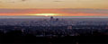
樂富泰山[2](英語:Mount Lofty),又譯巍峨山[3],是南澳州樂富泰山脈最高的山峰,位於南澳州首府阿德萊德以東15公里。樂富泰山頂是阿德萊德著名的旅遊景點,亦因其燈塔而聞名。山頂設觀景台、餐廳及精品店,觀景台能飽覽由西面的阿德萊德至東面的必嘉迪利之景色。
| 樂富泰山 Mount Lofty | |
|---|---|
 樂富泰山頂觀景台及燈塔 | |
| 最高点 | |
| 海拔 | 727米(2,385英尺) |
| 坐标 | 34°58′S 138°42′E / 34.967°S 138.700°E坐标:34°58′S 138°42′E / 34.967°S 138.700°E |
| 地理 | |
| 山脈 | 樂富泰山脈 |
| 攀山 | |
| 首次登頂 | 1831年4月 高勒·白加 |

前往樂富泰山的方式包括,開車可使用東南公路嘉佛士出口、青山道。步行則可由瀑布涌經潔蘭郊野公園及針八士涌,此段亦是最為人廣知的行山徑。亦有不少單車愛好者使用舊白加山道前往山頂。
歷史 编辑
樂富泰山頂 编辑

1802年3月23日,馬修·福林達斯在澳洲大陸探索旅程途中將此山命名為樂富泰山。[4]1831年4月,即阿德萊德建立前六年,歐洲探險家高勒·白加成為首個登頂之人。
原本山頂有一塊大石頭用作三角測量點用途,在1885年被一座方尖碑取代;以作測量用途。1902年,該方尖碑被命名為福林達斯塔(英語:Flinders Column)。[5]樂富泰山在第二次世界大戰期間關閉,福林達斯塔被改用作導航用途;塔裝上閃光燈以提高夜間可視度。塔上的閃光燈在戰後一度被移除,直至1990年代的燈塔翻髹工程才重新安裝。
1983年聖灰日火災中,樂富泰山亦遭到波及,不少山頂設施被燒毀,及後再進行重建。
樂富泰山頂道歷史建築 编辑
樂富泰山頂道(Mount Lofty Summit Road)沿路有屹立數座避暑別墅,亦有不少名人曾居住該處。但大部份避暑別墅在1983年聖灰日火災被燒毀,祇有幾座被重建:[6]
聖邁克爾修道院(St. Michael's Monastery)、士打窩學校等建築被燒毀後,並沒有進行任何重建工程。[11]
氣候 编辑
在冬季,樂富泰山是阿德萊德地區最寒冷地區,部份日子溫度不會超過攝氏三至四度。阿德萊德屬地中海氣候,冬季溫暖多雨,即使氣溫急降仍不足以降雪;距離阿德萊德最近的雪地則位於700公里外的維多利亞州東部。儘管阿德萊德不常降雪,但樂富泰山頂下小雪的情況亦不罕見,降雪時間通常不多於一日。尤其是小童,降雪仍然對阿德萊德居民來說,是十分新奇的事物;下雪情況在過下多次成為本地報紙的頭版。[12]
| 樂富泰山 | |||||||||||||
|---|---|---|---|---|---|---|---|---|---|---|---|---|---|
| 月份 | 1月 | 2月 | 3月 | 4月 | 5月 | 6月 | 7月 | 8月 | 9月 | 10月 | 11月 | 12月 | 全年 |
| 历史最高温 °C(°F) | 38.7 (101.7) |
38.9 (102.0) |
33.4 (92.1) |
30.5 (86.9) |
24.5 (76.1) |
18.8 (65.8) |
16.9 (62.4) |
24.0 (75.2) |
27.0 (80.6) |
34.3 (93.7) |
37.1 (98.8) |
36.4 (97.5) |
38.9 (102.0) |
| 平均高温 °C(°F) | 22.7 (72.9) |
22.8 (73.0) |
19.9 (67.8) |
16.2 (61.2) |
12.5 (54.5) |
9.6 (49.3) |
8.8 (47.8) |
9.9 (49.8) |
12.6 (54.7) |
15.6 (60.1) |
18.4 (65.1) |
20.4 (68.7) |
15.8 (60.4) |
| 日均气温 °C(°F) | 17.6 (63.7) |
17.9 (64.2) |
15.7 (60.3) |
13.0 (55.4) |
10.2 (50.4) |
7.7 (45.9) |
6.9 (44.4) |
7.5 (45.5) |
9.5 (49.1) |
11.6 (52.9) |
13.8 (56.8) |
15.6 (60.1) |
12.3 (54.1) |
| 平均低温 °C(°F) | 12.4 (54.3) |
12.9 (55.2) |
11.4 (52.5) |
9.8 (49.6) |
7.9 (46.2) |
5.7 (42.3) |
4.9 (40.8) |
5.1 (41.2) |
6.3 (43.3) |
7.6 (45.7) |
9.3 (48.7) |
10.8 (51.4) |
8.7 (47.7) |
| 历史最低温 °C(°F) | 4.5 (40.1) |
4.4 (39.9) |
3.8 (38.8) |
1.1 (34.0) |
−0.4 (31.3) |
0.1 (32.2) |
−0.1 (31.8) |
−0.5 (31.1) |
0.6 (33.1) |
0.4 (32.7) |
1.6 (34.9) |
3.0 (37.4) |
−0.5 (31.1) |
| 平均降雨量 mm(英寸) | 40.6 (1.60) |
42.2 (1.66) |
54.7 (2.15) |
62.4 (2.46) |
124.7 (4.91) |
140.5 (5.53) |
173.9 (6.85) |
131.3 (5.17) |
123.8 (4.87) |
59.9 (2.36) |
39.6 (1.56) |
55.0 (2.17) |
1,047.3 (41.23) |
| 平均降雨天数 | 7.1 | 7.6 | 9.9 | 13.8 | 16.3 | 21.5 | 23.8 | 21.6 | 19.0 | 12.3 | 9.8 | 10.9 | 120.0 |
| 平均相對濕度(%) (3pm) | 51 | 50 | 56 | 60 | 73 | 82 | 80 | 72 | 70 | 64 | 58 | 53 | 64 |
| 数据来源:[13] | |||||||||||||
圖集 编辑
-
 樂富泰山降雪(1905年)
 -
 樂富泰山頂
樂富泰山頂 -
 樂富泰山向東南眺望白加山
 -
 福林達斯塔紀念牌匾
 -
 晚間山頂眺望阿德萊德
 -
 日間山頂眺望阿德萊德


參見 编辑
參考文獻 编辑
- ^ Search result for "Mount Lofty (Mountain)" (Record no. SA0041096) with the following layers selected - "Suburbs and Localities" and " Place names (gazetteer)". Property Location Browser. Government of South Australia. [19 July 2016]. (原始内容存档于2016-10-12).
- ^ 周定国 (编). Lofty,Mt. 洛夫蒂山 [澳]. 世界地名翻译大辞典. 北京: 中国对外翻译出版公司. 2008-01. ISBN 978-7-500-10753-8. OCLC 885528603. OL 23943703M. NLC 003756704.(简体中文)
- ^ 王聖文. 阿德雷得丘陵. 澳洲深度旅遊. 台北: 廣雅堂出版巀. 1998: 403. ISBN 9789579915724.
- ^ Flinders, Matthew. A Voyage to Terra Australis : undertaken for the purpose of completing the discovery of that vast country, and prosecuted in the years 1801, 1802, and 1803 in His Majesty's ship the Investigator, and subsequently in the armed vessel Porpoise and Cumberland Schooner; with an account of the shipwreck of the Porpoise, arrival of the Cumberland at Mauritius, and imprisonment of the commander during six years and a half in that island. Facsimile. Adelaide; Facsimile reprint of: London : G. and W. Nicol, 1814 ed. In two volumes, with an Atlas (3 volumes): Libraries Board of South Australia. 1966: 251 [1814] [4 January 2014]. (原始内容存档于2015-09-24).
- ^ Smith, Pam; Pate, F. Donald; Martin, Robert. Valleys of Stone: The Archaeology and History of Adelaide's Hills Face. Belair, South Australia: Kōpi Books. 2006: 232. ISBN 0 975 7359-6-9.
- ^ Wall, Barbara. Mount Lofty Summit Road: A survey 1841-2008 (research paper). 2008 [2018-06-24]. (原始内容存档于2015-09-23).
- ^ Explore Mt Lofty House. Mt Lofty House - Adelaide Hills - Grand Mercure. [6 May 2013]. (原始内容存档于2013-08-25). History (页面存档备份,存于互联网档案馆)
- ^ Amanda Ward. Eurilla rises again. SA Life Magazine, vol. 5, no. 2: 32–43. February 2008 [17 June 2012]. (原始内容存档于11 April 2013).
Keelan, Michael. Eurilla : for the love of trees. SA Life Magazine, vol. 5, no. 2: 44–51. February 2008 [17 June 2012]. (原始内容存档于11 April 2013).
Photos: 1890 Archive.is的存檔,存档日期2012-07-09,1890 Archive.is的存檔,存档日期2012-07-16,1905 Archive.is的存檔,存档日期2012-07-09,1983[永久失效連結]. See also: [1] (页面存档备份,存于互联网档案馆),Archived copy. [2012-06-16]. (原始内容存档于2012-03-22).,Archived copy (PDF). [2012-06-16]. (原始内容 (PDF)存档于2009-05-20). - ^ Fayette Gosse. Elder, Sir Thomas (1818–1897). Australian Dictionary of Biography, National Centre of Biography, Australian National University. [6 May 2013]. (原始内容存档于2014-12-25).
- ^ A Trip to Mount Lofty, 31 March 1906, The Advertiser pg.6
- ^ Barbara Wall A Short History of Stawell School: The forgotten school on Mount Lofty published for Mount Lofty Districts Historical Society by Peacock Publications 2012 ISBN 978-1-921601-69-9
- ^ Advertiser coverage of "Snow at Mt Lofty": 1 August 2014; 22 July 2013 (页面存档备份,存于互联网档案馆); 11 October 2012 (页面存档备份,存于互联网档案馆).
- ^ Climate statistics for Australian locations. www.bom.gov.au. [24 January 2018]. (原始内容存档于2020-12-02).
外部連結 编辑
- 潔蘭郊野公園官方網站 (页面存档备份,存于互联网档案馆)