File:1598 map of the Polar Regions by Willem Barentsz.jpg

本预览的尺寸:800 × 592像素。 其他分辨率:320 × 237像素 | 640 × 474像素 | 1,024 × 758像素 | 1,280 × 948像素 | 2,560 × 1,896像素 | 13,719 × 10,160像素。
原始文件 (13,719 × 10,160像素,文件大小:30.66 MB,MIME类型:image/jpeg)
摘要
| 警告 | 部分浏览器在浏览此图片的完整大小时可能会遇到困难:该图片中有数量巨大的像素点,可能无法完全载入或者导致您的浏览器停止响应。 |
|---|
| 描述 |
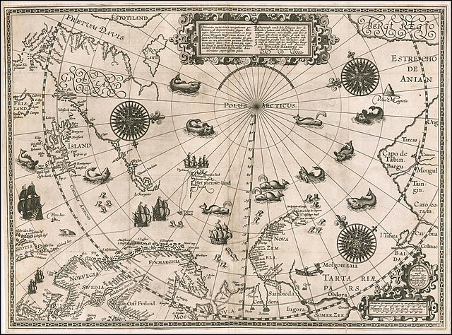
English: 1598 map of the Polar Regions by Willem Barentsz
Latina: Deliniatio cartae trium navigationum per Batavos, ad Septentrionalem plagam, Norvegiae, Moscoviae, et novae Semblae, et perque fretum Weygatis Nassovicum dictum, ac juxta Groenlandiam, sub altitudine 80. graduum nec non adiacentium partium Tartariae, promontorij Tabin, freti Anian atque regionis Bargi et partis Americae versus orientem, Authore Wilhelmo Bernardo Amstelredamo experissimo pilota.
Nederlands: Beschryvinghe vande drie seylagien door de Hollanders gedaen ande Noordt syde van Noorweghen, Moscovia, nova Sembla, ende door de Weygats ofte Strate de Nassou so mede het' deel van Groenlandt op de 80. graeden ende de omleggende grensen van Tartaryen, ende de Capo de Tabin ende des landtschaps Bargi, so oock het Oostersche deel van America: door Willem Barents van Amstelredam de vermaerde Piloot |
| 日期 | |
| 来源 | Barry Lawrence Rare Maps, from an original 1598 print. |
| 作者 | Original charts by Willem Barentsz, map drawn by Cornelis Claesz ("Cornelius Nicolai"), engraved by Baptista van Doetecum ("Baptista a Doetechum") |
| 其他版本 |
|
.jpg)

_door_Willem_Barendsz_(titel_op_object),_NG-800.jpg)


许可协议
|
本作品在其来源国以及其他著作权期限是作者逝世后70年或以下的国家和地区属于公有领域。 | |
| 本文件已被确认为免除已知的著作权法限制(包括所有相关权利)。 | |
| 註解 | 該圖片含有註解:在維基媒體共享資源上查看註解 |
文件历史
点击某个日期/时间查看对应时刻的文件。
| 日期/时间 | 缩略图 | 大小 | 用户 | 备注 | |
|---|---|---|---|---|---|
| 当前 | 2020年3月22日 (日) 18:42 | | 13,719 × 10,160(30.66 MB) | Balkanique | Uploaded a work by Willem Barentsz from https://www.raremaps.com/gallery/detail/59238/deliniatio-cartae-trium-navigationum-per-batavos-ad-septent-barentsz with UploadWizard |
文件用途
以下页面使用本文件:
全域文件用途
以下其他wiki使用此文件:
- ar.wikipedia.org上的用途
- ast.wikipedia.org上的用途
- ca.wikipedia.org上的用途
- cs.wikipedia.org上的用途
- da.wikipedia.org上的用途
- de.wikipedia.org上的用途
- en.wikipedia.org上的用途
- es.wikipedia.org上的用途
- fr.wikipedia.org上的用途
- hy.wikipedia.org上的用途
- is.wikipedia.org上的用途
- it.wikipedia.org上的用途
- ja.wikipedia.org上的用途
- la.wikipedia.org上的用途
- nl.wikipedia.org上的用途
- no.wikipedia.org上的用途
- pl.wikipedia.org上的用途
- pt.wikipedia.org上的用途
- sl.wikipedia.org上的用途
- sr.wikipedia.org上的用途
- uk.wikipedia.org上的用途
- vi.wikipedia.org上的用途