File:1865 Spruner Map Israel or Palestine post 70 AD.jpg
本预览的尺寸:372 × 599像素。 其他分辨率:149 × 240像素 | 298 × 480像素 | 476 × 768像素 | 635 × 1,024像素 | 1,353 × 2,180像素。
原始文件 (1,353 × 2,180像素,文件大小:1.39 MB,MIME类型:image/jpeg)
摘要
| 作者 |
|
||
| 描述 |
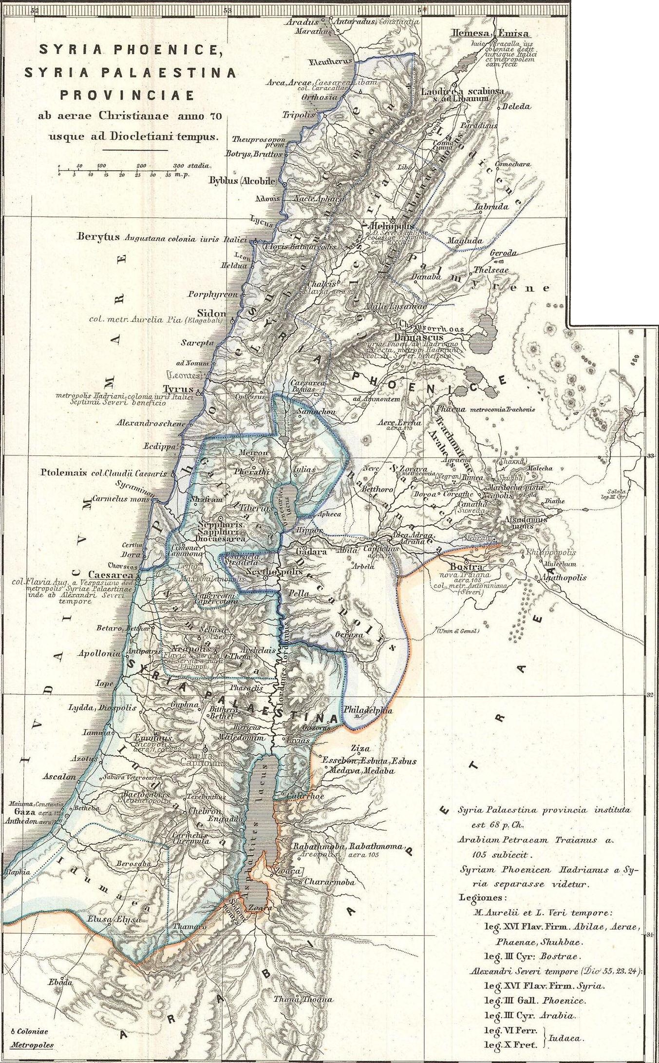
English: This is Karl von Spruner’s 1865 map of the Holy Land, or Israel and Palestine. Essentially nine maps in one, Spruner features two dominant maps and 7 smaller insets, including a Peutinger Table in the lower-right quadrant. The Peutinger Map is an astoundingly important discovery and is today’s only known example of a Roman world map, though the original Peutinger was itself a mediaeval copy of the Roman original. This map also shows, in counter-clock wise order from the Peutinger table, Galilaea, Hierosolyma, Judaea, Palestine at the time of Herod, Syria, Arabia, and Phoeniciae, Palestine, and Arabia. Many of the insets include their own scale or legend. Map notes important cities, rivers, mountain ranges and other minor topographical detail. Territories and countries outlined in color. The whole is rendered in finely engraved detail exhibiting throughout the fine craftsmanship of the Perthes firm. |
||
| 日期 | 1865年 (undated) | ||
| 尺寸 | 高度:16英寸(40.6厘米);寬度:13英寸(33厘米) | ||
| 登录号 |
Geographicus link: Phoenice-spruner-1865 |
||
| 来源/摄影师 |
本檔案衍生自: 1865 Spruner Map of the Holy Land, Israel, or Palestine in Antiquity - Geographicus - Phoenice-spruner-1865.jpg: |
| 这是一张修改过的图片,这意味着它已在原版本的基础上通过软件进行了编辑,改动内容:Map divided into 2/3 parts (maps)。其原始版本为:1865 Spruner Map of the Holy Land, Israel, or Palestine in Antiquity - Geographicus - Phoenice-spruner-1865.jpg。修改者:Cristiano64。
|
许可协议
|
这是一个平面公有领域艺术品的忠实摄影副本。原艺术品本身因为下列原因属于公有领域:
维基媒体基金会的官方立场认为:“对平面公有领域艺术品的忠实再制作品也属于公有领域。”
因此,可以认为此摄影副本在美国也属于公有领域。在其他司法管辖区,再利用此内容可能存在限制;参见再利用PD-Art照片了解详细信息。 | ||||
原始上传日志
This image is a derivative work of the following images:
- File:1865_Spruner_Map_of_the_Holy_Land,_Israel,_or_Palestine_in_Antiquity_-_Geographicus_-_Phoenice-spruner-1865.jpg licensed with PD-Art
- 2011-03-25T05:57:05Z BotMultichillT 3500x2897 (2712725 Bytes) {{subst:User:Multichill/Geographicus |link=http://www.geographicus.com/P/AntiqueMap/Phoenice-spruner-1865 |product_name=1865 Spruner Map of the Holy Land, Israel, or Palestine in Antiquity |map_title=Phoenice, Coelesyria, Dec
Uploaded with derivativeFX
文件历史
点击某个日期/时间查看对应时刻的文件。
| 日期/时间 | 缩略图 | 大小 | 用户 | 备注 | |
|---|---|---|---|---|---|
| 当前 | 2013年1月10日 (四) 08:29 | | 1,353 × 2,180(1.39 MB) | Cristiano64 | == {{int:filedesc}} == {{Information |Description={{en|This is Karl von Spruner’s 1865 map of the Holy Land, or Israel and Palestine. Essentially nine maps in one, Spruner features two dominant maps and 7 smaller insets, including a Peutinger Table ... |
文件用途
以下页面使用本文件:
全域文件用途
以下其他wiki使用此文件:
- ar.wikipedia.org上的用途
- en.wikipedia.org上的用途
- eo.wikipedia.org上的用途
- it.wikipedia.org上的用途
- mk.wikipedia.org上的用途
- mt.wikipedia.org上的用途
- ru.wikipedia.org上的用途