File:AYool SEAWIFS annual.png

本预览的尺寸:800 × 544像素。 其他分辨率:320 × 217像素 | 640 × 435像素 | 1,024 × 696像素 | 1,280 × 870像素 | 1,667 × 1,133像素。
原始文件 (1,667 × 1,133像素,文件大小:453 KB,MIME类型:image/png)
摘要
| 描述 |
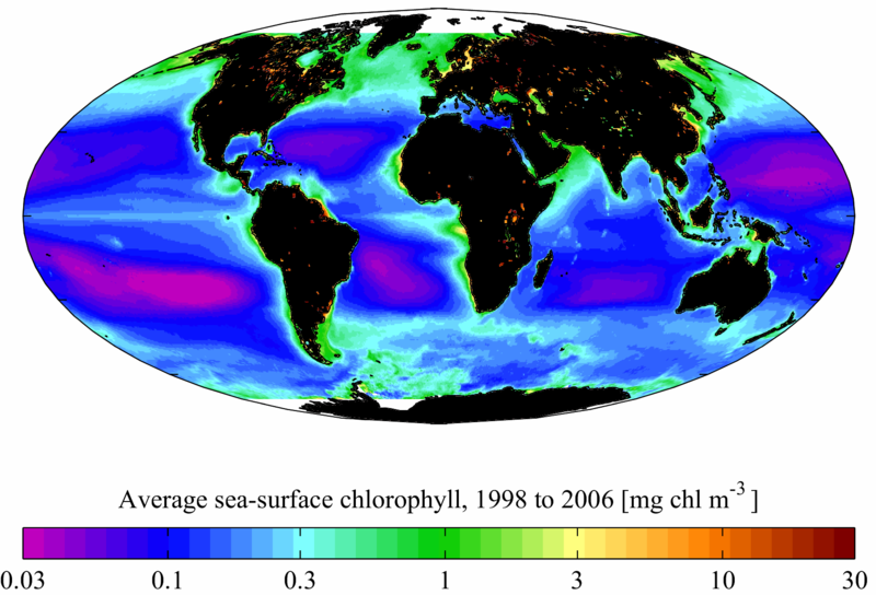
English: Average sea surface chlorophyll for the period January 1998 to December 2006 from the SeaWIFS satellite. The average is composed from 8 day composites with a spatial resolution of 0.5° in latitude and longitude. Chlorophyll is in mg chl m-3 (note that the colour scale is logarithmic). It is plotted here using a Mollweide projection (using MATLAB and the M_Map package).
Français : teneur moyenne des eaux de surface en chlorophylle a, pour la période 1998-2006 ; Attention l'échelle est logarithmique |
| 日期 | |
| 来源 | 自己的作品 (原始文本: self-made) |
| 作者 | Plumbago (talk) |
许可协议
本文件采用知识共享署名-相同方式共享 3.0 未本地化版本许可协议授权。
- 您可以自由地:
- 共享 – 复制、发行并传播本作品
- 修改 – 改编作品
- 惟须遵守下列条件:
- 署名 – 您必须对作品进行署名,提供授权条款的链接,并说明是否对原始内容进行了更改。您可以用任何合理的方式来署名,但不得以任何方式表明许可人认可您或您的使用。
- 相同方式共享 – 如果您再混合、转换或者基于本作品进行创作,您必须以与原先许可协议相同或相兼容的许可协议分发您贡献的作品。

|
已授权您依据自由软件基金会发行的无固定段落及封面封底文字(Invariant Sections, Front-Cover Texts, and Back-Cover Texts)的GNU自由文件许可协议1.2版或任意后续版本的条款,复制、传播和/或修改本文件。该协议的副本请见“GNU Free Documentation License”。 |
您可以选择您需要的许可协议。
原始上传日志
原始描述頁面位於這裡。下列使用者名稱均來自en.wikipedia。
- 2008-04-01 13:53 Plumbago 1667×1133× (558075 bytes) {{Information |Description=Average sea surface [[chlorophyll]] for the period January 1998 to December 2006 from the [[SeaWIFS]] [[satellite]]. The average is composed from 8 day [[Digital compositing|composites]]. Chlorophyll here is in [[Gram#SI multi
文件历史
点击某个日期/时间查看对应时刻的文件。
| 日期/时间 | 缩略图 | 大小 | 用户 | 备注 | |
|---|---|---|---|---|---|
| 当前 | 2014年8月12日 (二) 11:28 | | 1,667 × 1,133(453 KB) | LlywelynII | Unhelpful white landforms to black: all remaining coastal or inland artifacts present in original, some obviously displaying lakes. Non-included seas in Arctic and Antarctic left white. |
| 2009年2月10日 (二) 20:45 |  | 1,667 × 1,133(545 KB) | Lamiot | {{Information |Description={{en|Average sea surface chlorophyll for the period January 1998 to December 2006 from the SeaWIFS satellite. The average is composed from 8 day composites with a spatial resolution of 0.5° in latitude and longitude. Chlorophyl |
文件用途
全域文件用途
以下其他wiki使用此文件:
- ar.wikipedia.org上的用途
- ba.wikipedia.org上的用途
- bg.wikipedia.org上的用途
- bn.wikipedia.org上的用途
- de.wikipedia.org上的用途
- en.wikipedia.org上的用途
- fa.wikipedia.org上的用途
- fr.wikipedia.org上的用途
- gu.wikipedia.org上的用途
- he.wikipedia.org上的用途
- kn.wikipedia.org上的用途
- pl.wikipedia.org上的用途
- pt.wikipedia.org上的用途
- ru.wikipedia.org上的用途
- simple.wikipedia.org上的用途
- ta.wikipedia.org上的用途
- te.wikipedia.org上的用途
- uk.wikipedia.org上的用途