File:Approximate extension of Alodia based on accounts of Ibn Hawqal.png

本预览的尺寸:800 × 581像素。 其他分辨率:320 × 232像素 | 640 × 464像素 | 813 × 590像素。
原始文件 (813 × 590像素,文件大小:106 KB,MIME类型:image/png)
摘要
| 描述 |
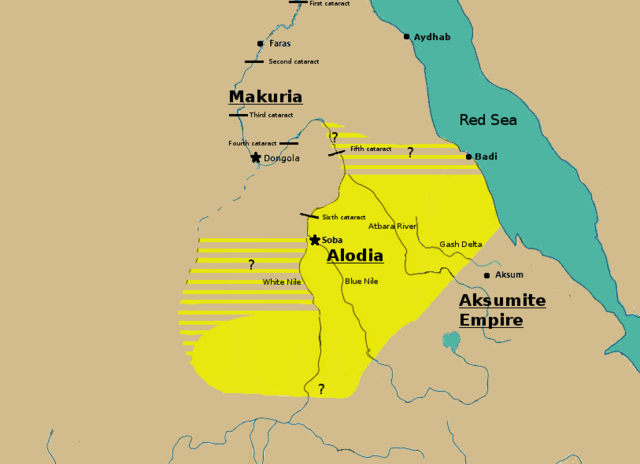
English: Initially based on map IX from the book "The Kingdom of Alwa" (see the first four versions of the map to see the faithful copy).[1] The original map had several problems, so I decided to modify it. 1) Zarroug had Alodia extend as far west as Darfur. However, there is still virtually no archaeological evidence supporting this assumption.[2] 2) The exact nothern border is still desputed; it is generally placed between Abu Hamad and the confluence of the Nile and the Atbara.[3] 3) Zarroug shows all regions west of the Nile as part of Alodia. However, the traveller Ibn Hawqal explicitly stated that parts of the region west of the White Nile were part of Makuria. The Nuba mountains were probably part of Alodia, hence I included stripes and a question mark for the area between the confluence of the two Niles and the Nuba mountains.[4] 4) There is little evidence that the Bayuda desert (between ed Debba and Omdurman) was part of either Makuria or Alodia.[5]
|
| 日期 | |
| 来源 | 自己的作品 |
| 作者 | LeGabrie |
许可协议
我,本作品著作权人,特此采用以下许可协议发表本作品:
本文件采用知识共享署名-相同方式共享 4.0 国际许可协议授权。
- 您可以自由地:
- 共享 – 复制、发行并传播本作品
- 修改 – 改编作品
- 惟须遵守下列条件:
- 署名 – 您必须对作品进行署名,提供授权条款的链接,并说明是否对原始内容进行了更改。您可以用任何合理的方式来署名,但不得以任何方式表明许可人认可您或您的使用。
- 相同方式共享 – 如果您再混合、转换或者基于本作品进行创作,您必须以与原先许可协议相同或相兼容的许可协议分发您贡献的作品。
文件历史
点击某个日期/时间查看对应时刻的文件。
| 日期/时间 | 缩略图 | 大小 | 用户 | 备注 | |
|---|---|---|---|---|---|
| 当前 | 2018年11月27日 (二) 15:20 | | 813 × 590(106 KB) | LeGabrie | Deleted stripes in Bayuda desert |
| 2018年10月28日 (日) 15:47 |  | 703 × 590(114 KB) | LeGabrie | decreased width | |
| 2018年10月15日 (一) 12:51 |  | 813 × 590(108 KB) | LeGabrie | Added Gash Delta | |
| 2018年9月29日 (六) 11:38 |  | 813 × 590(108 KB) | LeGabrie | Extended the beams over the entire Bayuda | |
| 2018年9月4日 (二) 12:12 |  | 813 × 590(111 KB) | LeGabrie | added question mark | |
| 2018年9月4日 (二) 11:59 |  | 813 × 590(108 KB) | LeGabrie | Cut the beams in Darfur | |
| 2018年9月1日 (六) 00:55 |  | 813 × 590(114 KB) | LeGabrie | Increased script size | |
| 2018年9月1日 (六) 00:51 |  | 813 × 590(114 KB) | LeGabrie | small fix | |
| 2018年9月1日 (六) 00:49 |  | 813 × 590(114 KB) | LeGabrie | Made it prettier | |
| 2018年2月1日 (四) 21:14 |  | 813 × 590(155 KB) | LeGabrie | Added white beams and question marks to highlight the uncertainties of Zarroug's map. These uncertainties are: The extension into Darfur,the question of ownership of northern Kordofan and the beginning of Al-Abwab. The concrete amount of desert aside o... |
文件用途
以下2个页面使用本文件:
全域文件用途
以下其他wiki使用此文件:
- ar.wikipedia.org上的用途
- arz.wikipedia.org上的用途
- azb.wikipedia.org上的用途
- cs.wikipedia.org上的用途
- de.wikipedia.org上的用途
- en.wikipedia.org上的用途
- es.wikipedia.org上的用途
- fa.wikipedia.org上的用途
- fi.wikipedia.org上的用途
- fr.wikipedia.org上的用途
- id.wikipedia.org上的用途
- ms.wikipedia.org上的用途
- nl.wikipedia.org上的用途
- pt.wikipedia.org上的用途
- ru.wikipedia.org上的用途
- sl.wikipedia.org上的用途
- sr.wikipedia.org上的用途
- sv.wikipedia.org上的用途
- ta.wikipedia.org上的用途
- th.wikipedia.org上的用途
- tl.wikipedia.org上的用途
- uk.wikipedia.org上的用途
- vi.wikipedia.org上的用途