File:AxelHeibergIslandCloseupMap.png
此为最大尺寸。
AxelHeibergIslandCloseupMap.png (499 × 449像素,文件大小:13 KB,MIME类型:image/png)
摘要
| 描述 |
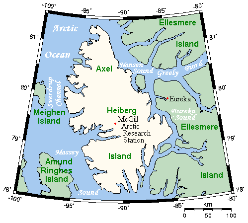
English: A map of Axel Heiberg Island, Nunavut, Canada, and surrounding islands and waterways. |
| 日期 | |
| 来源 | This map's source is here, with the uploader's modifications, and the GMT homepage says that the tools are released under the GNU General Public License. |
| 作者 | Kelisi at en.wikipedia |
许可协议
| 本文件采用知识共享署名-相同方式共享 3.0 未本地化版本许可协议授权。 受免責聲明的約束。 | ||
| 署名: Kelisi 位于英语维基百科 | ||
| ||
| 本许可协议标签作为GFDL许可协议更新的组成部分被添加至本文件。 |

|
已授权您依据自由软件基金会发行的无固定段落及封面封底文字(Invariant Sections, Front-Cover Texts, and Back-Cover Texts)的GNU自由文件许可协议1.2版或任意后续版本的条款,复制、传播和/或修改本文件。该协议的副本请见“GNU Free Documentation License”。 受免責聲明的約束。 |
原始上传日志
(del) (cur) 19:38, 26 March 2006 . . Kelisi (Talk) . . 499x449 (17403 bytes) (A map of Axel Heiberg Island, Nunavut, and surrounding islands and waterways. This map's source is [http://www.aquarius.ifm-geomar.de/ here], with the uploader's modifications, and the [http://gmt.soest.hawaii.edu/ GMT homepage] says that the tools are released under the GNU General Public License).
文件历史
点击某个日期/时间查看对应时刻的文件。
| 日期/时间 | 缩略图 | 大小 | 用户 | 备注 | |
|---|---|---|---|---|---|
| 当前 | 2007年11月9日 (五) 13:37 | | 499 × 449(13 KB) | MaxSem | pngcrush'ed |
| 2006年4月23日 (日) 15:19 |  | 499 × 449(17 KB) | MaxSem | Original description: <tt> A map of Axel Heiberg Island, Nunavut, and surrounding islands and waterways. This map's source is here, with the uploader's modifications, and the GMT homepage says that the tools are released under the GNU General Public Licen |
文件用途
以下页面使用本文件:
全域文件用途
以下其他wiki使用此文件:
- af.wikipedia.org上的用途
- ast.wikipedia.org上的用途
- az.wikipedia.org上的用途
- ba.wikipedia.org上的用途
- bg.wikipedia.org上的用途
- ca.wikipedia.org上的用途
- ceb.wikipedia.org上的用途
- cs.wikipedia.org上的用途
- da.wikipedia.org上的用途
- de.wikipedia.org上的用途
- en.wikipedia.org上的用途
- es.wikipedia.org上的用途
- fa.wikipedia.org上的用途
- gl.wikipedia.org上的用途
- hu.wikipedia.org上的用途
- it.wikipedia.org上的用途
- ka.wikipedia.org上的用途
- nl.wikipedia.org上的用途
- nn.wikipedia.org上的用途
- no.wikipedia.org上的用途
- pl.wikipedia.org上的用途
- pt.wikipedia.org上的用途
- ro.wikipedia.org上的用途
- ru.wikipedia.org上的用途
- simple.wikipedia.org上的用途
- sr.wikipedia.org上的用途
- uk.wikipedia.org上的用途
- vi.wikipedia.org上的用途
- war.wikipedia.org上的用途
- www.wikidata.org上的用途