File:BNSF Railway system map.svg

此SVG文件的PNG预览的大小:800 × 457像素。 其他分辨率:320 × 183像素 | 640 × 366像素 | 1,024 × 585像素 | 1,280 × 731像素 | 2,560 × 1,463像素 | 1,400 × 800像素。
原始文件 (SVG文件,尺寸为1,400 × 800像素,文件大小:1.62 MB)
摘要
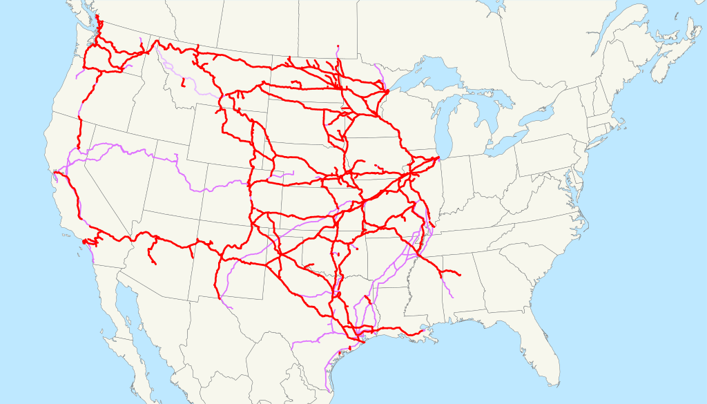
| 描述 | This is a map of the BNSF Railway as of 2009, with trackage rights in purple (haulage rights are lighter). Email me if you would like a copy of the GIS data I created (modified from Bureau of Transportation Statistics North American Transportation Atlas Data) or if you see any errors. |
| 日期 | 2009年2月23日 (原始上传日期) |
| 来源 | 无法识别来源。根据版权声明推断为其自己的作品。 |
| 作者 | 无法识别作者。根据版权声明推断作者为NE2。 |
许可协议
| 我,本作品著作权人,释出本作品至公有领域。这适用于全世界。 在一些国家这可能不合法;如果是这样的话,那么: 我无条件地授予任何人以任何目的使用本作品的权利,除非这些条件是法律规定所必需的。 |
文件历史
点击某个日期/时间查看对应时刻的文件。
| 日期/时间 | 缩略图 | 大小 | 用户 | 备注 | |
|---|---|---|---|---|---|
| 当前 | 2022年10月25日 (二) 05:14 | | 1,400 × 800(1.62 MB) | Fluffy89502 | Tracks south of Fullerton, CA has been owned by the State of California prior to 2009 |
| 2009年2月23日 (一) 13:03 |  | 1,400 × 800(1.51 MB) | NE2 | == Summary == This is a map of the BNSF Railway as of 2009, with trackage rights in purple (haulage rights are lighter). Email me if you would like a copy of the GIS data I created (mod |
文件用途
以下页面使用本文件:
全域文件用途
以下其他wiki使用此文件:
- da.wikipedia.org上的用途
- de.wikipedia.org上的用途
- en.wikipedia.org上的用途
- BNSF Railway
- Talk:Passenger transport executive
- Talk:Scottish Bus Group
- Talk:Stagecoach in Lincolnshire
- Template:WikiProject Trains
- Wikipedia:WikiProject Trains/Maps task force
- Category:Trains project maps task force articles
- Category talk:Trains project maps task force articles
- Category talk:Rail transport articles needing maps
- Wikipedia talk:WikiProject Trains/Maps task force
- Category talk:Railroad maps
- File talk:Queen city map.jpg
- Talk:Metro (Belfast)
- Talk:Optile
- Category:New York City public transportation articles needing maps
- Talk:Central Maryland Regional Transit
- Talk:Blackburn Bus Company
- Talk:Arriva Midlands East
- Talk:Western SMT
- Talk:Lancashire United Transport
- Talk:CityLink Gold (BaltimoreLink)
- Talk:Oxford Bus Company
- Talk:LocalLink 93 (BaltimoreLink)
- Talk:LocalLink 94 (BaltimoreLink)
- Talk:LocalLink 95 (BaltimoreLink)
- Talk:CityLink Red (BaltimoreLink)
- Talk:LocalLink 54 (BaltimoreLink)
- Talk:Route 15 (MTA Maryland)
- Talk:LocalLink 56 (BaltimoreLink)
- Talk:CityLink Orange (BaltimoreLink)
- Talk:LocalLink 78 (BaltimoreLink)
- Talk:Route 7 (MTA Maryland)
- Talk:LocalLink 67 (BaltimoreLink)
- Talk:LocalLink 80 (BaltimoreLink)
- Talk:CityLink Pink (BaltimoreLink)
- Talk:Route 21 (MTA Maryland)
- Talk:LocalLink 70 (BaltimoreLink)
- Template:WikiProject Buses
- Template talk:Eurostar
- Talk:Bristol park and ride
- Talk:Ulsterbus
- Talk:Arriva Midlands
- Talk:Noctilien
- File talk:Northisland NZ NIMT.png
- Talk:Cavendish Motor Services
- File talk:Northisland NZ East-Coast-Main-Trunk.png
- Talk:Barr Subdivision
- Template talk:DLR RDT
查看本文件的更多全域用途。