File:Baikal-S1999276045323.png

本预览的尺寸:800 × 563像素。 其他分辨率:320 × 225像素 | 640 × 450像素 | 1,024 × 720像素 | 1,220 × 858像素。
原始文件 (1,220 × 858像素,文件大小:1.9 MB,MIME类型:image/png)
| 描述 |
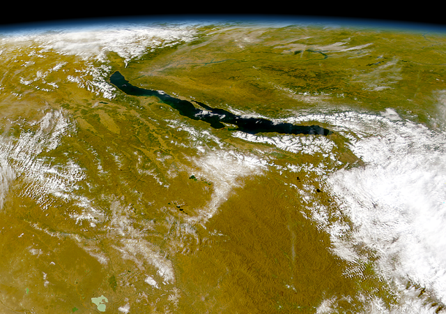
Čeština: Bajkal
|
||||
| 日期 | |||||
| 来源 | http://visibleearth.nasa.gov/view_rec.php?id=1002 - http://visibleearth.nasa.gov/images/1002/S1999276045323.png | ||||
| 作者 | Provided by the SeaWiFS Project, NASA/Goddard Space Flight Center, and ORBIMAGE | ||||
| 授权 (二次使用本文件) |
|
文件历史
点击某个日期/时间查看对应时刻的文件。
| 日期/时间 | 缩略图 | 大小 | 用户 | 备注 | |
|---|---|---|---|---|---|
| 当前 | 2005年7月21日 (四) 03:57 | | 1,220 × 858(1.9 MB) | Bdk | Lake Baikal *Source: http://visibleearth.nasa.gov/view_rec.php?id=1002 - http://visibleearth.nasa.gov/images/1002/S1999276045323.png *Sensor OrbView-2/SeaWiFS *Dates: Datastart 1999-10-03 - Visualization Date 1999-10-03 *Visible Earth v1 ID 3678 *Credit: |
文件用途
以下页面使用本文件:
全域文件用途
以下其他wiki使用此文件:
- ar.wikipedia.org上的用途
- arz.wikipedia.org上的用途
- ast.wikipedia.org上的用途
- as.wikipedia.org上的用途
- az.wikipedia.org上的用途
- be.wikipedia.org上的用途
- ca.wikipedia.org上的用途
- ce.wikipedia.org上的用途
- crh.wikipedia.org上的用途
- cs.wikipedia.org上的用途
- cy.wikipedia.org上的用途
- de.wikipedia.org上的用途
- de.wikivoyage.org上的用途
- de.wiktionary.org上的用途
- diq.wikipedia.org上的用途
- el.wikipedia.org上的用途
- en.wikipedia.org上的用途
- eo.wikipedia.org上的用途
- es.wikipedia.org上的用途
- eu.wikipedia.org上的用途
- fa.wikipedia.org上的用途
- fr.wikivoyage.org上的用途
- ga.wikipedia.org上的用途
- he.wikipedia.org上的用途
- hr.wikipedia.org上的用途
- hu.wikipedia.org上的用途
- hy.wikipedia.org上的用途
- it.wikipedia.org上的用途
- ja.wikipedia.org上的用途
- ka.wikipedia.org上的用途
- kbp.wikipedia.org上的用途
- kk.wikipedia.org上的用途
- lb.wikipedia.org上的用途
- lmo.wikipedia.org上的用途
- lv.wikipedia.org上的用途
- mhr.wikipedia.org上的用途
- myv.wikipedia.org上的用途
- my.wikipedia.org上的用途
- mzn.wikipedia.org上的用途
查看本文件的更多全域用途。