File:Bounty Voyages Map.png
本预览的尺寸:800 × 583像素。 其他分辨率:320 × 233像素 | 640 × 467像素 | 934 × 681像素。
原始文件 (934 × 681像素,文件大小:37 KB,MIME类型:image/png)

|
此map图片可使用矢量图形重新创建为SVG文件。这具有很多好处;更多信息请参见共享资源:待清理媒体。如果存在此图片的SVG格式,请将其上传,然后将此模板替换为
{{vector version available|新图片名称}}。
建议您将SVG命名为“Bounty Voyages Map.svg”,这样在使用Vector version available(或Vva)模板时就不需要填写新图片名称参数。 |
摘要
| 描述 |
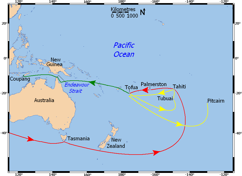
Deutsch: Karte der Reiseroute der Bounty. Rot: Reiseroute vor der Meuterei, gelb: Route der Bounty nach der Meuterei. grün: Fahrt der Barkassse unter Kapitän Bligh. Einige der kleinen Inseln sind nicht maßstabsgetreu wiedergegeben.
English: Labeled map of the voyages of HMS Bounty in the south Pacific: voyage prior to mutiny is red, voyage of Bounty after mutiny is yellow, voyage of Bligh and others in the longboat is green. Five labeled small islands enlarged for visibility (not to scale).
Français : Carte montrant la navigation du navire HMS Bounty dans l'océan Pacifique de 1788 à 1790 :
|
| 日期 | |
| 来源 |
个人作品,使用:
|
| 作者 | Ruhrfisch (talk) |
| 授权 (二次使用本文件) |
GFDL, CC-BY-SA |
| 其他版本 |
No labels - base map  |
许可协议
我,本作品著作权人,特此采用以下许可协议发表本作品:

|
已授权您依据自由软件基金会发行的无固定段落及封面封底文字(Invariant Sections, Front-Cover Texts, and Back-Cover Texts)的GNU自由文件许可协议1.2版或任意后续版本的条款,复制、传播和/或修改本文件。该协议的副本请见“GNU Free Documentation License”。 |
This file is licensed under the Creative Commons Attribution-Share Alike Attribution-Share Alike 4.0 International, 3.0 Unported, 2.5 Generic, 2.0 Generic and 1.0 Generic license.
- 您可以自由地:
- 共享 – 复制、发行并传播本作品
- 修改 – 改编作品
- 惟须遵守下列条件:
- 署名 – 您必须对作品进行署名,提供授权条款的链接,并说明是否对原始内容进行了更改。您可以用任何合理的方式来署名,但不得以任何方式表明许可人认可您或您的使用。
- 相同方式共享 – 如果您再混合、转换或者基于本作品进行创作,您必须以与原先许可协议相同或相兼容的许可协议分发您贡献的作品。
您可以选择您需要的许可协议。
文件历史
点击某个日期/时间查看对应时刻的文件。
| 日期/时间 | 缩略图 | 大小 | 用户 | 备注 | |
|---|---|---|---|---|---|
| 当前 | 2009年12月29日 (二) 13:11 | | 934 × 681(37 KB) | Ruhrfisch | Moved Pacific Ocean label and enlarged it, removed Tongatabu label, enlarged labeled small islands for visibility, moved red line below Australia to enter map about 40 degrees south. |
| 2009年12月29日 (二) 04:07 |  | 934 × 681(37 KB) | Ruhrfisch | == Summary == {{Information |Description= Labeled map of the voyages of the ''HMAV Bounty'': voyage prior to mutiny is red, voyage of ''Bounty'' after mutiny is yellow, voyage of Bligh and others in the longboat is green. |Source= I stitched together two |
文件用途
以下页面使用本文件:
全域文件用途
以下其他wiki使用此文件:
- ar.wikipedia.org上的用途
- bg.wikipedia.org上的用途
- da.wikipedia.org上的用途
- en.wikipedia.org上的用途
- eo.wikipedia.org上的用途
- fi.wikipedia.org上的用途
- fr.wikipedia.org上的用途
- hr.wikipedia.org上的用途
- id.wikipedia.org上的用途
- it.wikipedia.org上的用途
- ja.wikipedia.org上的用途
- la.wikipedia.org上的用途
- lt.wikipedia.org上的用途
- pl.wikipedia.org上的用途
- pt.wikipedia.org上的用途
- ro.wikipedia.org上的用途
- ru.wikipedia.org上的用途
- sr.wikipedia.org上的用途
- uk.wikipedia.org上的用途