File:CEMA members.png

本预览的尺寸:800 × 351像素。 其他分辨率:320 × 140像素 | 640 × 281像素 | 1,425 × 625像素。
原始文件 (1,425 × 625像素,文件大小:56 KB,MIME类型:image/png)
摘要

|
File:Comecon.svg是此文件的矢量版本。 应当将此点阵图片替换为该文件。
File:CEMA members.png → File:Comecon.svg
更多信息请参阅Help:SVG/zh。 |
 |
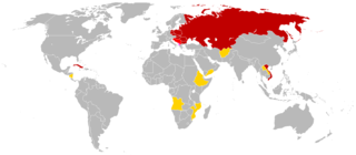
English: This is a map of the members of en:Comecon (aka the Council for Mutual Economic Assistance - CEMA). This map is based of the 1985 blank world map. The CIA World Factbook of 1991 had an profile for Comecon; this profile was used as reference. The text of the profile is below:
Council for Mutual Economic Assistance (CEMA), also known as
CMEA or Comecon, was established 25 January 1949 to promote the
development of socialist economies and was abolished 1 January 1991;
members included Afghanistan (observer), Albania (had not participated
since 1961 break with USSR), Angola (observer), Bulgaria, Cuba,
Czechoslovakia, Ethiopia (observer), GDR, Hungary, Laos (observer),
Mongolia, Mozambique (observer), Nicaragua (observer), Poland, Romania,
USSR, Vietnam, Yemen (observer), Yugoslavia (associate)
link: 1991 CIA World Factbook at the Wiretap Electronic Text Archive archive copy at the Wayback Machine
Note: Even though the Factbook lists "Yemen", I think is logical to conclude that North Yemen wouldn't have joined Comecon since it wasn't communist.
Key
members
members who did not participate
associates
observers
许可协议
| 本作品已被作者Hoshie释出到公有领域。这适用于全世界。 在一些国家这可能不合法;如果是这样的话,那么: |
文件历史
点击某个日期/时间查看对应时刻的文件。
| 日期/时间 | 缩略图 | 大小 | 用户 | 备注 | |
|---|---|---|---|---|---|
| 当前 | 2014年3月5日 (三) 04:59 | | 1,425 × 625(56 KB) | Grachifan | uploading |
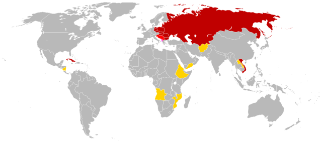
| 2010年2月27日 (六) 09:07 |  | 841 × 529(37 KB) | Hoshie | Made a few geographic changes: added Walvis Bay (Nambia; part of S. Africa during CEMA's existence); fixed the boundries of the PDRY. | |
| 2008年10月10日 (五) 21:03 |  | 841 × 529(23 KB) | Milosevo | {{Information |Description= |Source= |Date= |Author= |Permission= |other_versions= }} | |
| 2008年1月21日 (一) 14:13 |  | 841 × 529(23 KB) | Aivazovsky~commonswiki | {{Information |Description= |Source= |Date= |Author= |Permission= |other_versions= }} | |
| 2008年1月21日 (一) 13:59 |  | 841 × 529(23 KB) | Aivazovsky~commonswiki | Updated | |
| 2007年6月29日 (五) 03:59 |  | 832 × 490(30 KB) | Hoshie | added Cabinda (between Angola and Zaire). under same lic. as original. | |
| 2006年11月22日 (三) 20:49 |  | 832 × 490(20 KB) | Hoshie | put Albania in a more bold color - #FF40FF | |
| 2006年11月18日 (六) 08:27 |  | 832 × 490(20 KB) | Hoshie | forgot Afghanistan. I have added it. | |
| 2006年11月18日 (六) 07:54 |  | 842 × 496(20 KB) | Hoshie | This is a map of the members of en:Comecon (aka the Council for Mutual Economic Assistance - CEMA). This map is based of the 1985 blank world map. The World Factbook of 1991 has an profile for Comecon; this profile |
文件用途
没有页面链接到本图像。
全域文件用途
以下其他wiki使用此文件:
- als.wikipedia.org上的用途
- ar.wikipedia.org上的用途
- be.wikipedia.org上的用途
- de.wikipedia.org上的用途
- en.wikipedia.org上的用途
- fa.wikipedia.org上的用途
- gl.wikipedia.org上的用途
- hu.wikipedia.org上的用途
- no.wikipedia.org上的用途
- tl.wikipedia.org上的用途
- uk.wikipedia.org上的用途