File:CaminoRealAdentro.png
本预览的尺寸:614 × 600像素。 其他分辨率:246 × 240像素 | 491 × 480像素 | 698 × 682像素。
原始文件 (698 × 682像素,文件大小:374 KB,MIME类型:image/png)
摘要
| 描述 |
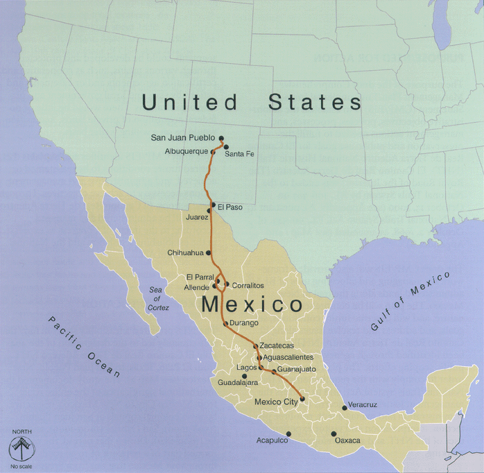
English: Map of Camino Real de Adentro of the Spanish Viceroyalty of New Spain:
Español: Mapa del Camino Real de Tierra Adentro del Virreinato de Nueva España:
|
| 来源 | http://www.nps.gov/elca |
| 作者 | U.S. National Park Service |

|
此map图片可使用矢量图形重新创建为SVG文件。这具有很多好处;更多信息请参见共享资源:待清理媒体。如果存在此图片的SVG格式,请将其上传,然后将此模板替换为
{{vector version available|新图片名称}}。
建议您将SVG命名为“CaminoRealAdentro.svg”,这样在使用Vector version available(或Vva)模板时就不需要填写新图片名称参数。 |
许可协议
| 该图片或媒体为美国国家公园管理局雇员在执行公务时创建。作为美国联邦政府的作品,此作品在美国境内属于公有领域。更多信息请参考美国国家公园管理局网站及美国国家公园管理局版权政策。 |
原始上传日志
| 日期/时间 | 大小 | 用户 | 备注 |
|---|---|---|---|
| 2008年7月24日, 06:28:04 | 698 × 682 (250345 bytes) | Arturoramos (留言 · 贡献) | {{Information |Description={{en|1=Map of Camino Real de Adentro in Colonial Mexico running from Mexico City to Santa Fe and San Juan, New Mexico}} |Source=http://www.nps.gov/elca |Author=U.S. Natiional Park Service |Date= |Permission= |other_versions= }} |
文件历史
点击某个日期/时间查看对应时刻的文件。
| 日期/时间 | 缩略图 | 大小 | 用户 | 备注 | |
|---|---|---|---|---|---|
| 当前 | 2014年8月29日 (五) 07:57 | | 698 × 682(374 KB) | GifTagger | Bot: Converting file to superior PNG file. (Source: CaminoRealAdentro.gif). This GIF was problematic due to non-greyscale color table. |
文件用途
以下页面使用本文件:
全域文件用途
以下其他wiki使用此文件:
- ast.wikipedia.org上的用途
- az.wikipedia.org上的用途
- be.wikipedia.org上的用途
- bn.wikipedia.org上的用途
- ca.wikipedia.org上的用途
- cs.wikipedia.org上的用途
- de.wikipedia.org上的用途
- en.wikipedia.org上的用途
- en.wikivoyage.org上的用途
- eo.wikipedia.org上的用途
- es.wikipedia.org上的用途
- Zacatecas
- Conquista de México
- Apaseo el Grande
- Anexo:Patrimonio de la Humanidad en América Latina y el Caribe
- Camino Real de Tierra Adentro
- Anexo:Patrimonio de la Humanidad en México
- Usuario:Vivero/revisiónconquista
- Sistema nacional de senderos de los Estados Unidos
- Usuario:Feuerfluss/taller
- Usuario:Xexito/Taller
- fr.wikipedia.org上的用途
- fr.wikivoyage.org上的用途
- he.wikipedia.org上的用途
- hr.wikipedia.org上的用途
- hy.wikipedia.org上的用途
- it.wikipedia.org上的用途
- it.wikivoyage.org上的用途
- ja.wikipedia.org上的用途
- ka.wikipedia.org上的用途
- kk.wikipedia.org上的用途
- lt.wikipedia.org上的用途
- mt.wikipedia.org上的用途
- nl.wikipedia.org上的用途
- no.wikipedia.org上的用途
- pt.wikipedia.org上的用途
- ru.wikipedia.org上的用途
查看本文件的更多全域用途。