File:China-Tibet.png
此为最大尺寸。
China-Tibet.png (268 × 218像素,文件大小:15 KB,MIME类型:image/png)
摘要
| 描述 |
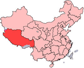
English: Location of Tibet Autonomous Region in the People's Republic of China. See Locator maps of province-level divisions of the People's Republic of China for more information.
Español: Localización de Tíbet dentro de China. Véase también: mapas de otras provincias.
Lo rosa es China, lo rojo la región de Tíbet y lo gris territorios que China considera propios pero controlados por otro estado vecino.
中文:西藏自治區在中華人民共和國的位置。另見Locator maps of province-level divisions of the People's Republic of China。 |
||||||||
| 日期 | |||||||||
| 来源 | made | ||||||||
| 作者 | Ran | ||||||||
| 授权 (二次使用本文件) |
|

文件历史
点击某个日期/时间查看对应时刻的文件。
| 日期/时间 | 缩略图 | 大小 | 用户 | 备注 | |
|---|---|---|---|---|---|
| 当前 | 2005年7月15日 (五) 14:56 | | 268 × 218(15 KB) | Schaengel89~commonswiki | transparent background |
| 2005年6月4日 (六) 22:38 |  | 268 × 218(8 KB) | Ran | '''en''': Location of Tibet Autonomous Region in the People's Republic of China. See Category:Locator maps of province-level divisions of the People's Republic of China for more information. '''zh''': 西藏自治區在中華人民共和國的位置 |
文件用途
全域文件用途
以下其他wiki使用此文件:
- ar.wikipedia.org上的用途
- arz.wikipedia.org上的用途
- ceb.wikipedia.org上的用途
- cs.wikipedia.org上的用途
- cs.wikinews.org上的用途
- de.wikipedia.org上的用途
- el.wikipedia.org上的用途
- en.wikipedia.org上的用途
- es.wikipedia.org上的用途
- fa.wikipedia.org上的用途
- fr.wikipedia.org上的用途
- Tibet
- Lhassa
- Région autonome du Tibet
- Modèle:Palette Tibet
- Liste des subdivisions administratives de la région autonome du Tibet
- Préfecture de Nagchu
- Préfecture de Ngari
- Linzhi
- Chengguan, Chamdo
- Ville-préfecture de Shannan
- Ville-préfecture de Shigatsé
- Politique au Tibet
- Gouvernement de la région autonome du Tibet
- Utilisateur:Rédacteur Tibet/Brouillon
- fr.wiktionary.org上的用途
- hi.wikipedia.org上的用途
- ht.wikipedia.org上的用途
- hu.wikipedia.org上的用途
查看本文件的更多全域用途。