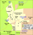
File:Colton Point and Leonard Harrison State Parks Map.png
Colton_Point_and_Leonard_Harrison_State_Parks_Map.png (455 × 481像素,文件大小:22 KB,MIME类型:image/png)
文件历史
点击某个日期/时间查看对应时刻的文件。
| 日期/时间 | 缩略图 | 大小 | 用户 | 备注 | |
|---|---|---|---|---|---|
| 当前 | 2010年4月1日 (四) 19:17 |  | 455 × 481(22 KB) | Ruhrfisch | Mkae state forest green less bright |
| 2008年10月8日 (三) 03:38 |  | 455 × 481(22 KB) | Ruhrfisch | Make creeks darker blue for better visibility and contrast, all other information is the same. | |
| 2008年8月8日 (五) 15:43 |  | 455 × 481(22 KB) | Ruhrfisch | Add Shippen Township label, all other information is the same | |
| 2008年8月8日 (五) 13:27 |  | 455 × 481(22 KB) | Ruhrfisch | Now cropped and labeled, base map is the same as before | |
| 2008年8月6日 (三) 20:09 |  | 571 × 595(21 KB) | Ruhrfisch | Updated version with Pine Creek Rail Trail along Creek, Turkey Path between two parks and West RIm Trail shown. Also moved the Delmar Twonship line west slightly to reflect the PennDOT map better and to keep mouth of Stowell Run and Leonard Harrison Stat | |
| 2008年7月31日 (四) 00:55 |  | 571 × 595(19 KB) | Ruhrfisch | {{Information| |Description= Map of Black Moshannon State Park, Centre County, Pennsylvania, USA |Source= water and roads taken from US Census website [http://factfinder.census.gov/] and modified by User:Ruhrfisch, property boundaries based on [ftp:/ |
文件用途
以下页面使用本文件:
全域文件用途
以下其他wiki使用此文件:
- en.wikipedia.org上的用途
- User talk:Brighterorange/Archive2
- User talk:Choess/Archive4
- Talk:Leonard Harrison State Park
- User:SandyGeorgia/Barnstars
- User:Finetooth/Honors
- User talk:Jackyd101/Archive 4
- User talk:Tony1/Archive 1
- User talk:Ealdgyth/Archive 5
- User talk:Dweller/Archive 23
- User talk:SandyGeorgia/arch40
- User talk:Ben MacDui/Archive 7
- User talk:Niagara/Archive 4
- User:Gerry D/archive10
- User talk:Michael Devore/Archive 2
- User talk:Finetooth/Archive 4


