File:East-Hem 050ad.jpg

原始文件 (3,240 × 1,903像素,文件大小:722 KB,MIME类型:image/jpeg)

|
此historical map图片可使用矢量图形重新创建为SVG文件。这具有很多好处;更多信息请参见共享资源:待清理媒体。如果存在此图片的SVG格式,请将其上传,然后将此模板替换为
{{vector version available|新图片名称}}。
建议您将SVG命名为“East-Hem 050ad.svg”,这样在使用Vector version available(或Vva)模板时就不需要填写新图片名称参数。 |


摘要
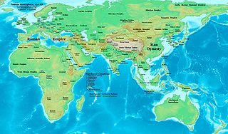
| 描述 | Eastern Hemisphere in 050 AD. |
| 来源 | 自己的作品 (For reference information, see the Map Source References section below.) |
| 作者 | Thomas Lessman (Contact!) |
| 授权 (二次使用本文件) |
我,本作品著作权人,特此采用以下许可协议发表本作品: 本文件采用知识共享署名-相同方式共享 3.0 未本地化版本许可协议授权。
|
| 其他版本 | East-Hem_050ad.jpg file history on Wikipedia. |
Map Summary
Original Source URL: http://www.thomaslessman.com/History/images/East-Hem_050ad.jpg.
This map of the Eastern Hemisphere in 050 AD was created by Thomas Lessman, based on information from the sources listed below. This map is free for educational use (see Permission info above). When using this map, please mention that it is available for free at www.WorldHistoryMaps.info.
Map Source References
- Remember, sources often conflict with each other. This map is only as accurate as the information that is available to me. To report any errors or to help further this work, please click here, or email Thomas Lessman at talessman@yis.us
References for information contained in this map:
1. Borders of Europe are mostly derived from the www.Euratlas.com maps of Europe in 001 AD archive copy at the Wayback Machine and from their map of Europe in 100 AD archive copy at the Wayback Machine.
2. Borders of Asian countries are derive from the following sources:
- a - The DK Atlas of World History, 2000 Edition; map of The World in 1 CE, (Pages 42-43) was used for information on several Asian borders in this map.
- b - Korean borders derive from this map of Korea_001.png made by Wikipedia User:Historiographer.
3. Some info also derive from Wikimedia's map of the World_in_50_CE.
4. Much of the information in this map was cross-checked with Bruce Gordon's Regnal Chronologies.
Other Maps by Thomas Lessman
| Maps of the eastern hemisphere showing history
Bold dates are available on Wikimedia or Wikipedia. | ||
| Primeval | ||
| Ancient
|
·| 600 BC | 550 BC | 527 BC | 500 BC |
400 BC | ·| 1 AD | 50 AD | 100 AD | 200 AD | 300 AD | | |
| Medieval |
·| 500 AD | 565 AD | 600 AD | 700 AD | | |
| Modern |
·| 1500 AD | · * For historical maps of the whole world, | |
文件历史
点击某个日期/时间查看对应时刻的文件。
| 日期/时间 | 缩略图 | 大小 | 用户 | 备注 | |
|---|---|---|---|---|---|
| 当前 | 2008年5月9日 (五) 15:53 | | 3,240 × 1,903(722 KB) | Talessman | {{Information |Description=Eastern Hemisphere in 050 AD |Source=self-made |Author=Thomas Lessman |Permission={{self|cc-by-sa-3.0}} }} |
文件用途
以下页面使用本文件:
全域文件用途
以下其他wiki使用此文件:
- ar.wikipedia.org上的用途
- bs.wikipedia.org上的用途
- ca.wikipedia.org上的用途
- en.wikipedia.org上的用途
- es.wikipedia.org上的用途
- fa.wikipedia.org上的用途
- fr.wikipedia.org上的用途
- gl.wikipedia.org上的用途
- hu.wikipedia.org上的用途
- inh.wikipedia.org上的用途
- ja.wikipedia.org上的用途
- mk.wikipedia.org上的用途
- pl.wikipedia.org上的用途
- pnb.wikipedia.org上的用途
- ro.wikipedia.org上的用途
- rue.wikipedia.org上的用途
- ru.wikipedia.org上的用途
- sh.wikipedia.org上的用途
- simple.wikipedia.org上的用途
- si.wikipedia.org上的用途
- sv.wikipedia.org上的用途
- sw.wikipedia.org上的用途
- ta.wikipedia.org上的用途
- tl.wikipedia.org上的用途
- ur.wikipedia.org上的用途
- vi.wikipedia.org上的用途