File:Edinburgh map.png
此为最大尺寸。
Edinburgh_map.png (734 × 573像素,文件大小:69 KB,MIME类型:image/png)

|
File:Edinburgh Old Town Boundaries with New Town.svg是此文件的矢量版本。 如果此文件质量不低于原点阵图,就应该将这个PNG格式文件替换为此文件。
File:Edinburgh map.png → File:Edinburgh Old Town Boundaries with New Town.svg
更多信息请参阅Help:SVG/zh。 |
 |
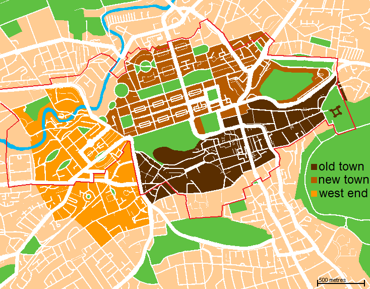
| 描述 | A map of the city centre of Edinburgh, Scotland. Old Town is in dark brown, New Town in light brown, West End is in yellow, and the World Heritage Site boundary is the red line. | ||
| 日期 | (UTC) | ||
| 来源 | Based loosely on http://www.aboutscotland.com/edin/newtown.html, updated based on the 'Edinburgh Navigator' maps. | ||
| 作者 | Jack · talk · | ||
| 授权 (二次使用本文件) |
|
| 我,本作品著作权人,释出本作品至公有领域。这适用于全世界。 在一些国家这可能不合法;如果是这样的话,那么: 我无条件地授予任何人以任何目的使用本作品的权利,除非这些条件是法律规定所必需的。 |
文件历史
点击某个日期/时间查看对应时刻的文件。
| 日期/时间 | 缩略图 | 大小 | 用户 | 备注 | |
|---|---|---|---|---|---|
| 当前 | 2009年11月8日 (日) 00:03 | | 734 × 573(69 KB) | Jrockley | altered to depict new town, old town, and west end instead. also now shows boundary of world heritage site. |
| 2007年11月19日 (一) 02:58 |  | 610 × 516(47 KB) | Jrockley | more greenery | |
| 2007年11月16日 (五) 17:32 |  | 610 × 516(46 KB) | Jrockley | move "Edinburgh" | |
| 2007年11月16日 (五) 03:43 |  | 610 × 516(47 KB) | Jrockley | more greenery | |
| 2007年11月16日 (五) 03:20 |  | 610 × 516(47 KB) | Jrockley | clearer map, based on Google data | |
| 2007年11月16日 (五) 01:19 |  | 500 × 432(30 KB) | Jrockley | {{Information |Description= Map of Central Edinburgh, showing New and Old Towns. |Source=Based loosely on http://www.aboutscotland.com/edin/newtown.html |Date=~~~~~ |Author=~~~ |Permission={{PD-self}} |other_versions= }} |
文件用途
全域文件用途
以下其他wiki使用此文件:
- af.wikipedia.org上的用途
- ang.wikipedia.org上的用途
- ba.wikipedia.org上的用途
- be.wikipedia.org上的用途
- ca.wikipedia.org上的用途
- cs.wikipedia.org上的用途
- de.wikipedia.org上的用途
- en.wikipedia.org上的用途
- Edinburgh
- Areas of Edinburgh
- New Town, Edinburgh
- Old Town, Edinburgh
- Talk:Edinburgh/Archive 2
- Wikipedia talk:WikiProject Edinburgh
- West End, Edinburgh
- List of Category A listed buildings in Edinburgh
- List of Category A listed buildings in the Old Town, Edinburgh
- List of Category A listed buildings in the New Town, Edinburgh
- es.wikipedia.org上的用途
- eu.wikipedia.org上的用途
- fi.wikipedia.org上的用途
- fr.wikipedia.org上的用途
- ga.wikipedia.org上的用途
- gl.wikipedia.org上的用途
- he.wikipedia.org上的用途
- hi.wikipedia.org上的用途
- hr.wikipedia.org上的用途
- hy.wikipedia.org上的用途
- ja.wikipedia.org上的用途
- kn.wikipedia.org上的用途
- ko.wikipedia.org上的用途
- nl.wikipedia.org上的用途
- pt.wikipedia.org上的用途
- ru.wikipedia.org上的用途
- sco.wikipedia.org上的用途
查看本文件的更多全域用途。