File:Emancipation Proclamation.PNG
本预览的尺寸:800 × 520像素。 其他分辨率:320 × 208像素 | 640 × 416像素 | 1,024 × 665像素 | 1,513 × 983像素。
原始文件 (1,513 × 983像素,文件大小:54 KB,MIME类型:image/png)

|
此historical map图片可使用矢量图形重新创建为SVG文件。这具有很多好处;更多信息请参见共享资源:待清理媒体。如果存在此图片的SVG格式,请将其上传,然后将此模板替换为
{{vector version available|新图片名称}}。
建议您将SVG命名为“Emancipation Proclamation.svg”,这样在使用Vector version available(或Vva)模板时就不需要填写新图片名称参数。 |
摘要
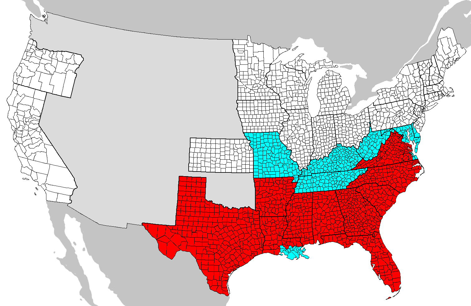
| 描述 | Map of counties covered (red) and not covered (blue) by the Emancipation Proclamation. Map needs updating as these county boundaries reflect modern boundaries and not those during 1862, with some counties displayed on this map not existing at the time. |
| 日期 | (UTC) |
| 来源 | |
| 作者 |
|
| 这是一张修改过的图片,这意味着它已在原版本的基础上通过软件进行了编辑,改动内容:Added colors。其原始版本为:Map of USA with county outlines.png。修改者:SFGiants。
|

|
已授权您依据自由软件基金会发行的无固定段落及封面封底文字(Invariant Sections, Front-Cover Texts, and Back-Cover Texts)的GNU自由文件许可协议1.2版或任意后续版本的条款,复制、传播和/或修改本文件。该协议的副本请见“GNU Free Documentation License”。 |
| 本文件采用知识共享署名-相同方式共享 3.0 未本地化版本许可协议授权。 | ||
| ||
| 本许可协议标签作为GFDL许可协议更新的组成部分被添加至本文件。 |
== 原始上传日志 == blue This image is a derivative work of the following images:
- Image:Map_of_USA_with_county_outlines.png licensed with GFDL
- 2008-01-23T04:41:16Z Speight 1513x983 (100713 Bytes) Fix San Francisco Bay and Puget Sound
- 2006-11-23T22:53:51Z Ibagli 1513x983 (169345 Bytes) more fixes
- 2006-11-23T22:53:05Z Ibagli 1513x983 (169416 Bytes) Reverted to earlier revision
- 2006-11-23T22:52:41Z Ibagli 1513x983 (184378 Bytes) more fixes
- 2006-11-23T02:16:28Z Ibagli 1513x983 (169416 Bytes) fix lake St. Clair
- 2005-08-28T20:57:13Z Huhsunqu 1513x983 (169340 Bytes) *{{es}} Mapa de los [[Estados Unidos de América]] mostrando los los límites de estados miembros y sus condados. Versión a colores de la adaptación hecha por [[en:User:Wapcaplet|Wapcaplet]] del mapa de dominio público del
Uploaded with derivativeFX
文件历史
点击某个日期/时间查看对应时刻的文件。
| 日期/时间 | 缩略图 | 大小 | 用户 | 备注 | |
|---|---|---|---|---|---|
| 当前 | 2020年6月14日 (日) 00:46 | | 1,513 × 983(54 KB) | JasonAQuest | remove non-states |
| 2008年6月1日 (日) 04:31 |  | 1,513 × 983(171 KB) | SFGiants | {{Information |Description=== Summary == Map of counties covered and not covered by the Emancipation Proclamation. |Source=*Image:Map_of_USA_with_county_outlines.png |Date=2008-06-01 04:29 (UTC) |Author=*derivative w |
文件用途
以下页面使用本文件:
全域文件用途
以下其他wiki使用此文件:
- cs.wikipedia.org上的用途
- da.wikipedia.org上的用途
- el.wikipedia.org上的用途
- en.wikipedia.org上的用途
- en.wikibooks.org上的用途
- fi.wikipedia.org上的用途
- fr.wikipedia.org上的用途
- he.wikipedia.org上的用途
- it.wikipedia.org上的用途
- ja.wikipedia.org上的用途
- ko.wikipedia.org上的用途
- simple.wikipedia.org上的用途
- sr.wikipedia.org上的用途