File:Fire Island-NY-USA-Location Map-01.svg

此SVG文件的PNG预览的大小:670 × 299像素。 其他分辨率:320 × 143像素 | 640 × 286像素 | 1,024 × 457像素 | 1,280 × 571像素 | 2,560 × 1,142像素。
原始文件 (SVG文件,尺寸为670 × 299像素,文件大小:215 KB)
摘要
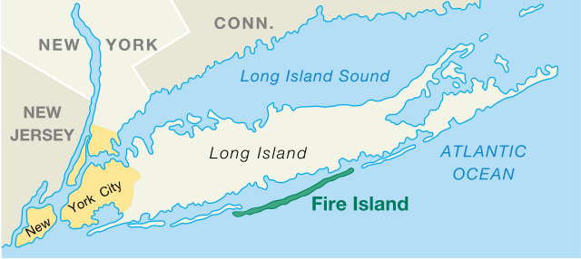
| 描述 | Fire Island, New York, US, Location Map |
| 日期 | created/published 2006-03-07 |
| 来源 | National Park Service, Area Map, converted from PDF file, modified |
| 作者 | U.S. Department of Interior, National Park Service |
| 其他版本 |
|

许可协议
| 该图片或媒体为美国国家公园管理局雇员在执行公务时创建。作为美国联邦政府的作品,此作品在美国境内属于公有领域。更多信息请参考美国国家公园管理局网站及美国国家公园管理局版权政策。 |
文件历史
点击某个日期/时间查看对应时刻的文件。
| 日期/时间 | 缩略图 | 大小 | 用户 | 备注 | |
|---|---|---|---|---|---|
| 当前 | 2017年10月27日 (五) 12:42 | | 670 × 299(215 KB) | Opencooper | == {{int:filedesc}} == {{Information |Description = Fire Island, New York, US, Location Map |Source = [http://www.nps.gov/fiis/pphtml/maps.html National Park Service], [https://web.archive.org/web/20041027185131/http://data2.itc.nps.gov:80/parks/fiis/p... |
文件用途
以下页面使用本文件:
全域文件用途
以下其他wiki使用此文件:
- ca.wikipedia.org上的用途
- de.wikipedia.org上的用途
- en.wikipedia.org上的用途
- en.wiktionary.org上的用途
- es.wikipedia.org上的用途
- et.wikipedia.org上的用途
- fa.wikipedia.org上的用途
- fi.wikipedia.org上的用途
- fr.wikipedia.org上的用途
- it.wikipedia.org上的用途
- ko.wikipedia.org上的用途
- no.wikipedia.org上的用途
- pl.wikipedia.org上的用途
- pt.wikipedia.org上的用途
- simple.wikipedia.org上的用途
- sv.wikipedia.org上的用途
- tr.wikipedia.org上的用途