File:Formative Period southern Mesoamerica 2.svg

此SVG文件的PNG预览的大小:800 × 380像素。 其他分辨率:320 × 152像素 | 640 × 304像素 | 1,024 × 486像素 | 1,280 × 608像素 | 2,560 × 1,215像素 | 1,241 × 589像素。
原始文件 (SVG文件,尺寸为1,241 × 589像素,文件大小:252 KB)
摘要
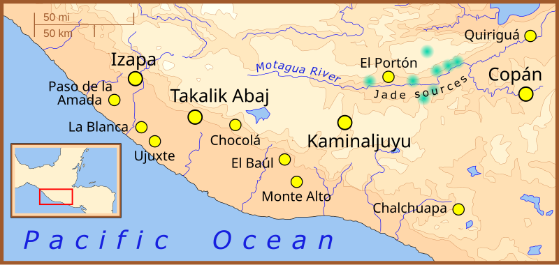
| 描述 | A map of the southern-most area of Mesoamerica, showing important Formative Period sites. |
| 日期 | |
| 来源 | 自己的作品 |
| 作者 | Madman2001 |
References
- Jadeite locations taken from: Lallemant, Hans G. Avé "Petrogenisis and Exhumation of Jadeitites in Guatemala", Rice University, accessed February 2008.
- Elevations based on those in the Times Atlas of the World, 7th edition.
- Location of archaeological sites taken from map for the upcoming book: "The Southern Maya Area in the Late Preclassic: Urbanism, Rulership, and Ethnic Interaction.", in press at the University Press of Colorado, Boulder, Michael Love and Jonathan Kaplan, eds.
许可协议
我,本作品著作权人,特此采用以下许可协议发表本作品:
本文件采用知识共享署名-相同方式共享 3.0 未本地化版本许可协议授权。
- 您可以自由地:
- 共享 – 复制、发行并传播本作品
- 修改 – 改编作品
- 惟须遵守下列条件:
- 署名 – 您必须对作品进行署名,提供授权条款的链接,并说明是否对原始内容进行了更改。您可以用任何合理的方式来署名,但不得以任何方式表明许可人认可您或您的使用。
- 相同方式共享 – 如果您再混合、转换或者基于本作品进行创作,您必须以与原先许可协议相同或相兼容的许可协议分发您贡献的作品。
文件历史
点击某个日期/时间查看对应时刻的文件。
| 日期/时间 | 缩略图 | 大小 | 用户 | 备注 | |
|---|---|---|---|---|---|
| 当前 | 2008年2月9日 (六) 01:22 | | 1,241 × 589(252 KB) | Madman2001 | Fixed mistake and added another site |
| 2008年2月7日 (四) 18:04 |  | 1,241 × 589(252 KB) | Madman2001 | fixed earlier mistake | |
| 2008年2月7日 (四) 17:41 |  | 1,241 × 589(224 KB) | Madman2001 | smaller formating changes | |
| 2008年2月7日 (四) 13:14 |  | 1,241 × 589(234 KB) | Madman2001 | {{Information |Description=A map of the southern-most area of Mesoamerica, showing important Formative Period sites. |Source=self-made |Date=February 2008 |Author= Madman2001 |Permission= |other_versions= }} |
文件用途
以下3个页面使用本文件:
全域文件用途
以下其他wiki使用此文件:
- af.wikipedia.org上的用途
- ar.wikipedia.org上的用途
- be.wikipedia.org上的用途
- bs.wikipedia.org上的用途
- de.wikipedia.org上的用途
- en.wikipedia.org上的用途
- es.wikipedia.org上的用途
- fi.wikipedia.org上的用途
- fi.wikibooks.org上的用途
- fr.wikipedia.org上的用途
- he.wikipedia.org上的用途
- hr.wikipedia.org上的用途
- hu.wikipedia.org上的用途
- id.wikipedia.org上的用途
- it.wikipedia.org上的用途
- ja.wikipedia.org上的用途
- ka.wikipedia.org上的用途
- lt.wikipedia.org上的用途
- nl.wikipedia.org上的用途
- pt.wikipedia.org上的用途
- ru.wikipedia.org上的用途
查看本文件的更多全域用途。