File:Gafilo 2004-03-03.jpg

本预览的尺寸:600 × 600像素。 其他分辨率:240 × 240像素 | 480 × 480像素 | 768 × 768像素 | 1,024 × 1,024像素 | 2,048 × 2,048像素 | 6,000 × 6,000像素。
原始文件 (6,000 × 6,000像素,文件大小:3.88 MB,MIME类型:image/jpeg)
摘要
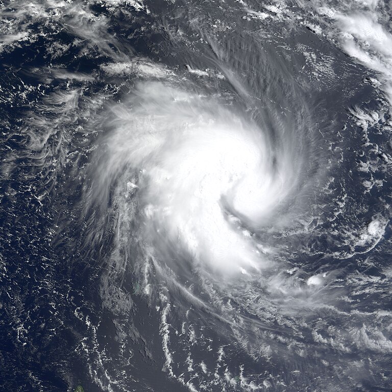
| 描述 | The MODIS instrument onboard NASA's Terra satellite captured this true-color image of Tropical Cyclone Gafilo as it was churning in the Indian Ocean approximately 800 miles northwest of northern Madagascar. At the time this image was acquired, Gafilo had maximum sustained winds near 75 mph and was moving west at 8 mph. Gafilo was expected to strengthen and take a turn towards the southwest and possibly affect northern Madagascar by the weekend. | |||||
| 日期 | ||||||
| 来源 | http://earthobservatory.nasa.gov/NaturalHazards/natural_hazards_v2.php3?img_id=11984 | |||||
| 作者 | Image courtesy Jesse Allen, NASA Earth Observatory at NASA GSFC. | |||||
| 授权 (二次使用本文件) |
|

文件历史
点击某个日期/时间查看对应时刻的文件。
| 日期/时间 | 缩略图 | 大小 | 用户 | 备注 | |
|---|---|---|---|---|---|
| 当前 | 2013年4月27日 (六) 12:10 | | 6,000 × 6,000(3.88 MB) | Meow | Official size |
| 2006年11月16日 (四) 20:54 |  | 6,000 × 6,000(4.68 MB) | Good kitty | == Summary == {{Information |Description=The MODIS instrument onboard NASA's Terra satellite captured this true-color image of Tropical Cyclone Gafilo as it was churning in the Indian Ocean approximately 800 miles northwest of northern Madagascar. At the |
文件用途
以下页面使用本文件:
全域文件用途
以下其他wiki使用此文件:
- en.wikipedia.org上的用途
- fr.wikipedia.org上的用途
- uk.wikipedia.org上的用途