File:Generalgouvernement fur die besetzten polnischen gebiete.png

本预览的尺寸:556 × 599像素。 其他分辨率:223 × 240像素 | 445 × 480像素 | 713 × 768像素 | 950 × 1,024像素 | 1,610 × 1,735像素。
原始文件 (1,610 × 1,735像素,文件大小:523 KB,MIME类型:image/png)
摘要
| 描述 |
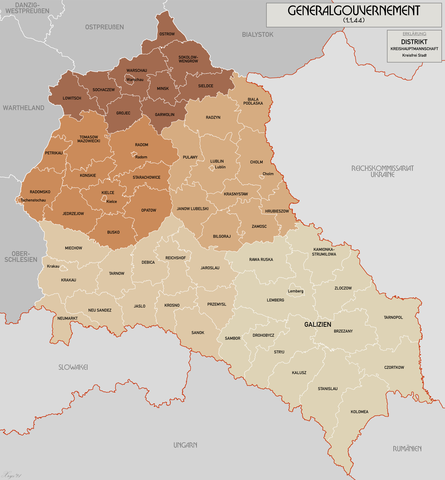
English: Administrative map of the Generalgouvernement für die besetzten polnischen Gebiete. |
| 日期 | |
| 来源 | 自己的作品 |
| 作者 | XrysD |
| 其他版本 | File:General Government for the occupied Polish territories.png |
许可协议
我,本作品著作权人,特此采用以下许可协议发表本作品:
本文件采用知识共享署名-相同方式共享 3.0 未本地化版本许可协议授权。
- 您可以自由地:
- 共享 – 复制、发行并传播本作品
- 修改 – 改编作品
- 惟须遵守下列条件:
- 署名 – 您必须对作品进行署名,提供授权条款的链接,并说明是否对原始内容进行了更改。您可以用任何合理的方式来署名,但不得以任何方式表明许可人认可您或您的使用。
- 相同方式共享 – 如果您再混合、转换或者基于本作品进行创作,您必须以与原先许可协议相同或相兼容的许可协议分发您贡献的作品。

|
已授权您依据自由软件基金会发行的无固定段落及封面封底文字(Invariant Sections, Front-Cover Texts, and Back-Cover Texts)的GNU自由文件许可协议1.2版或任意后续版本的条款,复制、传播和/或修改本文件。该协议的副本请见“GNU Free Documentation License”。 |
您可以选择您需要的许可协议。
文件历史
点击某个日期/时间查看对应时刻的文件。
| 日期/时间 | 缩略图 | 大小 | 用户 | 备注 | |
|---|---|---|---|---|---|
| 当前 | 2021年10月17日 (日) 10:11 | | 1,610 × 1,735(523 KB) | XrysD | Incorporated typos KRUBIESZOW->HRUBIESZOW and CZORTZOW->CZORTKOW |
| 2021年10月11日 (一) 18:12 |  | 1,610 × 1,735(575 KB) | Kamilhrub | Czortzow → Czortkow | |
| 2021年10月6日 (三) 10:30 |  | 1,610 × 1,735(575 KB) | Kamilhrub | Corrected name Hrubieszow and southern borders of Bilgoraj, Hrubieszow and Zamosc districts, which didn't change after 1941 (source: Amtliches Gemeinde- und Dorfverzeichnis für das Generalgouvernement auf Grund der Summarischen Bevölkerungsbestandsaufnahme am 1. März 1943) | |
| 2015年5月8日 (五) 09:41 |  | 1,610 × 1,735(438 KB) | RokerHRO | optipng -o7 -i0 → 21.79% decrease | |
| 2015年4月19日 (日) 10:36 |  | 1,610 × 1,735(560 KB) | XrysD | Komplett neue Karte. Grundkarte: Karte des Deutschen Reiches 1:100k, Karte von Mitteleuropa 1:300k, Mapa Administracyjna Rzeczypospolitej Polska 1:300k (Quelle mapyWIG). | |
| 2012年5月27日 (日) 16:18 |  | 2,299 × 2,280(398 KB) | XrysD | Fixed typos | |
| 2012年5月26日 (六) 19:51 |  | 2,299 × 2,280(396 KB) | XrysD | Changed version to all German Language. Changed all colours to use Bartholomew set. English language version can now be found under File:General Government for the occupied Polish territories.png | |
| 2012年5月26日 (六) 19:45 |  | 2,299 × 2,280(396 KB) | XrysD | Changed version to all German Language. Changed all colours to use Bartholomew set. English language version can now be found under File:General Government for the occupied Polish territories.png | |
| 2009年1月23日 (五) 20:38 |  | 2,299 × 2,280(391 KB) | XrysD | {{Information |Description= |Source= |Date= |Author= |Permission= |other_versions= }} | |
| 2008年11月29日 (六) 19:36 |  | 2,299 × 2,279(367 KB) | XrysD | {{Information |Description={{en|1=Administrative map of the Generalgouvernement für die besetzten polnischen Gebiete.}} |Source=Own work by uploader |Author=XrysD |Date=29/11/2008 |Permission= |other_versions= }} <!--{{ImageUpload|full}}- |
文件用途
以下页面使用本文件:
全域文件用途
以下其他wiki使用此文件:
- ar.wikipedia.org上的用途
- ast.wikipedia.org上的用途
- ba.wikipedia.org上的用途
- be-tarask.wikipedia.org上的用途
- ca.wikipedia.org上的用途
- cs.wikipedia.org上的用途
- de.wikipedia.org上的用途
- el.wikipedia.org上的用途
- es.wikipedia.org上的用途
- fi.wikipedia.org上的用途
- fr.wikipedia.org上的用途
- fr.wiktionary.org上的用途
- gl.wikipedia.org上的用途
- hu.wikipedia.org上的用途
- it.wikipedia.org上的用途
- sh.wikipedia.org上的用途
- simple.wikipedia.org上的用途
- sr.wikipedia.org上的用途
- sv.wikipedia.org上的用途
- uk.wikipedia.org上的用途
- www.wikidata.org上的用途