File:HRICoastLineMoasic H.jpg

本预览的尺寸:599 × 600像素。 其他分辨率:240 × 240像素 | 600 × 601像素。
原始文件 (600 × 601像素,文件大小:137 KB,MIME类型:image/jpeg)
摘要
| 描述 |
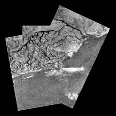
English: This mosaic of three frames provides unprecedented detail of the high ridge area including the flow down into a major river channel from different sources. This mosaic of three frames from the Huygens Descent Imager/ Spectral Radiometer (DISR) instrument provides unprecedented detail of the high ridge area including the flow down into a major river channel from different sources. |
||
| 日期 | |||
| 来源 | http://solarsystem.nasa.gov/galleries/titan-river-channel | ||
| 作者 | NASA | ||
| 授权 (二次使用本文件) |
|
许可协议
| 本文件完全由NASA创作,在美国属于公有领域。根据NASA的版权方针,NASA的材料除非另有声明否则不受版权保护。(参见Template:PD-USGov/zh、NASA版权方针页面或JPL图片使用方针。) | ||
 |
警告:
|
文件历史
点击某个日期/时间查看对应时刻的文件。
| 日期/时间 | 缩略图 | 大小 | 用户 | 备注 | |
|---|---|---|---|---|---|
| 当前 | 2015年9月25日 (五) 14:27 | | 600 × 601(137 KB) | Anton n | {{Information |Description ={{en|1=This mosaic of three frames provides unprecedented detail of the high ridge area including the flow down into a major river channel from different sources. This mosaic of three frames from the Huygens Descent Image... |
文件用途
以下页面使用本文件:
全域文件用途
以下其他wiki使用此文件:
- an.wikipedia.org上的用途
- ar.wikipedia.org上的用途
- en.wikipedia.org上的用途
- fr.wikibooks.org上的用途
- hy.wikipedia.org上的用途
- ja.wikipedia.org上的用途
- mk.wikipedia.org上的用途
- ru.wikipedia.org上的用途
- uk.wikipedia.org上的用途