File:Hartsville town square, southwestern corner.jpg

本预览的尺寸:800 × 600像素。 其他分辨率:320 × 240像素 | 640 × 480像素 | 1,024 × 768像素 | 1,280 × 960像素 | 2,560 × 1,920像素 | 2,816 × 2,112像素。
原始文件 (2,816 × 2,112像素,文件大小:1.68 MB,MIME类型:image/jpeg)
| 相机位置 | | 在以下服务上查看本图像和附近其他图像: OpenStreetMap |
|---|
| 描述 |
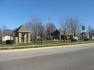
English: Southwestern corner of the town square in Hartsville, Indiana, United States, seen from State Road 46. The historical marker commemorates Hartsville native Corporal Barton W. Mitchell, whose discovery of Special Order 191 led to the Battle of Antietam in the American Civil War. |
||
| 日期 | 摄于2012年12月14日 | ||
| 来源 | 自己的作品 | ||
| 作者 | Nyttend | ||
| 授权 (二次使用本文件) |
|
文件历史
点击某个日期/时间查看对应时刻的文件。
| 日期/时间 | 缩略图 | 大小 | 用户 | 备注 | |
|---|---|---|---|---|---|
| 当前 | 2012年12月16日 (日) 14:30 | | 2,816 × 2,112(1.68 MB) | Nyttend | {{Location|40|16|4|N|85|41|56|W}} {{Information |Description={{en|Southwestern corner of the town square in {{w|Hartsville, Indiana|Hartsville}}, {{w|Indiana}}, {{w|United States}}, seen from {{w|Indiana State Road 46|State Road 46}}. The historical m... |
文件用途
以下2个页面使用本文件:
全域文件用途
以下其他wiki使用此文件:
- ar.wikipedia.org上的用途
- arz.wikipedia.org上的用途
- ca.wikipedia.org上的用途
- ceb.wikipedia.org上的用途
- ce.wikipedia.org上的用途
- en.wikipedia.org上的用途
- es.wikipedia.org上的用途
- eu.wikipedia.org上的用途
- fr.wikipedia.org上的用途
- ht.wikipedia.org上的用途
- it.wikipedia.org上的用途
- lld.wikipedia.org上的用途
- mzn.wikipedia.org上的用途
- no.wikipedia.org上的用途
- pl.wikipedia.org上的用途
- pt.wikipedia.org上的用途
- sh.wikipedia.org上的用途
- sr.wikipedia.org上的用途
- tt.wikipedia.org上的用途
- uk.wikipedia.org上的用途
- ur.wikipedia.org上的用途
- uz.wikipedia.org上的用途
- www.wikidata.org上的用途
- zh-min-nan.wikipedia.org上的用途