File:IND timeline.png
本预览的尺寸:407 × 600像素。 其他分辨率:163 × 240像素 | 326 × 480像素 | 521 × 768像素 | 695 × 1,024像素 | 2,447 × 3,606像素。
原始文件 (2,447 × 3,606像素,文件大小:203 KB,MIME类型:image/png)

|
此transport map图片可使用矢量图形重新创建为SVG文件。这具有很多好处;更多信息请参见共享资源:待清理媒体。如果存在此图片的SVG格式,请将其上传,然后将此模板替换为
{{vector version available|新图片名称}}。
建议您将SVG命名为“IND timeline.svg”,这样在使用Vector version available(或Vva)模板时就不需要填写新图片名称参数。 |
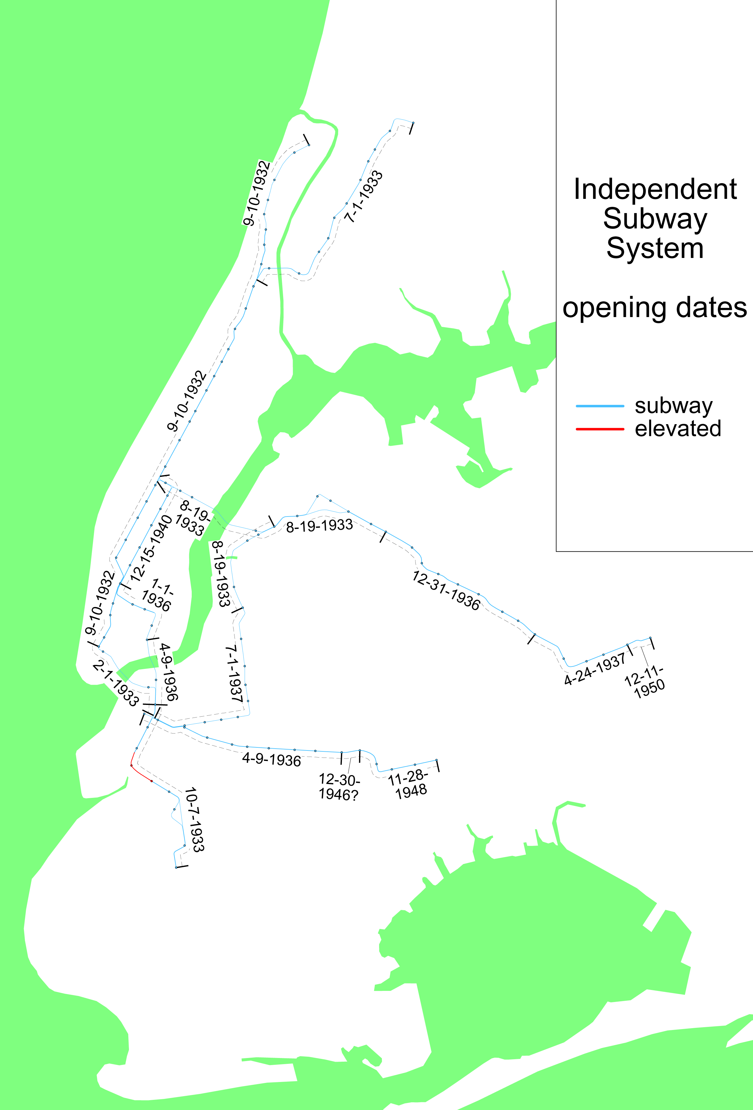
English: When each line of the w:Independent Subway System opened.
| 本作品已被作者SPUI释出到公有领域。这适用于全世界。 在一些国家这可能不合法;如果是这样的话,那么: |
License justification:
This image, asserted by the uploader to be drawn by the uploader, or modified from a map drawn by another uploader, and asserted not to be a copied image, is a map of all or part of the New York City subway system. The Metropolitan Transportation Authority (the "MTA") publishes several such maps, including two such current maps http://mta.info/nyct/maps/submap.htm and http://mta.info/nyct/maps/subwaymap.pdf, and possibly others. Their site, http://mta.info/ asserts copyright over all materials on the site, including the two referenced maps. Further, one user asserted "The design of the New York City subway system and all of its components, including maps of it and the line symbols used on those maps, are copyrighted by the MTA and its ancestors."
Questions have arisen about the copyright status of this or related maps, and in fact some of these maps have been deleted. See Commons:Undeletion_requests/Current requests#Image:NYC subway simplified map 50pct-optimized.png for discussion of this matter (diff link). Some of what follows is adapted from that discussion.
Some maps certainly are copyrighted, and some maps such as the two given above certainly are copyrighted by the MTA. Nonetheless, this map, is not copyright by the MTA under the following analysis.
- Any map that is a representation of features of the earth, drawn from knowledge of those features, and not directly a copy of another map, is not a copyright violation of any other particular map merely because it represents the same features. (for if it was it would be impossible to produce any map whatever that was free of hindrance).
- Therefore, it is possible to draw a map of the New York Subway system lines free of hindrance, which are after all features of the earth.
- Maps have markings. A map without markings is not as useful as one with. The letters and numbers used to designate the lines are a kind of knowledge of the features of the earth, just as the name of a town, or the reporting marks of a railway line, or a highway number are a kind of knowledge of the features of the earth (even if the railway reporting marks are a trademark of the railway company, they are nevertheless used on maps as identification). The markings of a map are not themselves copyrightable, only the arrangements of the markings (or the choice to include or not include specific markings) that make a particular version that version. So it is possible to correctly label such a subway map with the correct line designations, as long as in so doing one does not substantially duplicate the marking arrangement (as well as the precise choice of which markings to include or not include) on copyrighted maps.
- So then it is not impossible to create an accurate map of the subway system that is free. What remains is to determine if this map, which is substantially different in appearance than both of the maps that have been cited as evidence of copyright violation, nevertheless violates copyrights of the MTA or predecessors.
- We have ruled out the presence of features, and the markings of those features. What remains is color or symbology.
- Color? Color choice is trade dress, not copyright. Color cannot itself be copyrighted.
- The use of shapes for various line designation symbols? The shapes are squares and circles, not distinctive symbols that could be trademarked. They are very simple geometry, and thus not copyrightable. Only if a particular arrangement of the shapes mimics a copyrighted work, and it is an arrangment that is not logically obvious and necessary, is that arrangement an infringement.
文件历史
点击某个日期/时间查看对应时刻的文件。
| 日期/时间 | 缩略图 | 大小 | 用户 | 备注 | |
|---|---|---|---|---|---|
| 当前 | 2005年3月15日 (二) 22:14 | | 2,447 × 3,606(203 KB) | SPUI~commonswiki | fixed dates, all but the one with a question mark are confirmed by New York Times articles |
| 2005年2月8日 (二) 22:28 |  | 942 × 1,219(43 KB) | SPUI~commonswiki | {{spuimap}}When each line of the w:Independent Subway System opened. |
文件用途
以下页面使用本文件:
全域文件用途
以下其他wiki使用此文件:
- en.wikipedia.org上的用途
- es.wikipedia.org上的用途
- ja.wikipedia.org上的用途
- nl.wikipedia.org上的用途
- www.wikidata.org上的用途