File:Indigenous American Nations, 16th century - 2022 edition.jpg

本预览的尺寸:800 × 500像素。 其他分辨率:320 × 200像素 | 640 × 400像素 | 1,024 × 640像素 | 1,280 × 800像素 | 2,560 × 1,600像素 | 17,280 × 10,800像素。
原始文件 (17,280 × 10,800像素,文件大小:24.71 MB,MIME类型:image/jpeg)
摘要
| 警告 | 部分浏览器在浏览此图片的完整大小时可能会遇到困难:该图片中有数量巨大的像素点,可能无法完全载入或者导致您的浏览器停止响应。 |
|---|
| 描述 |
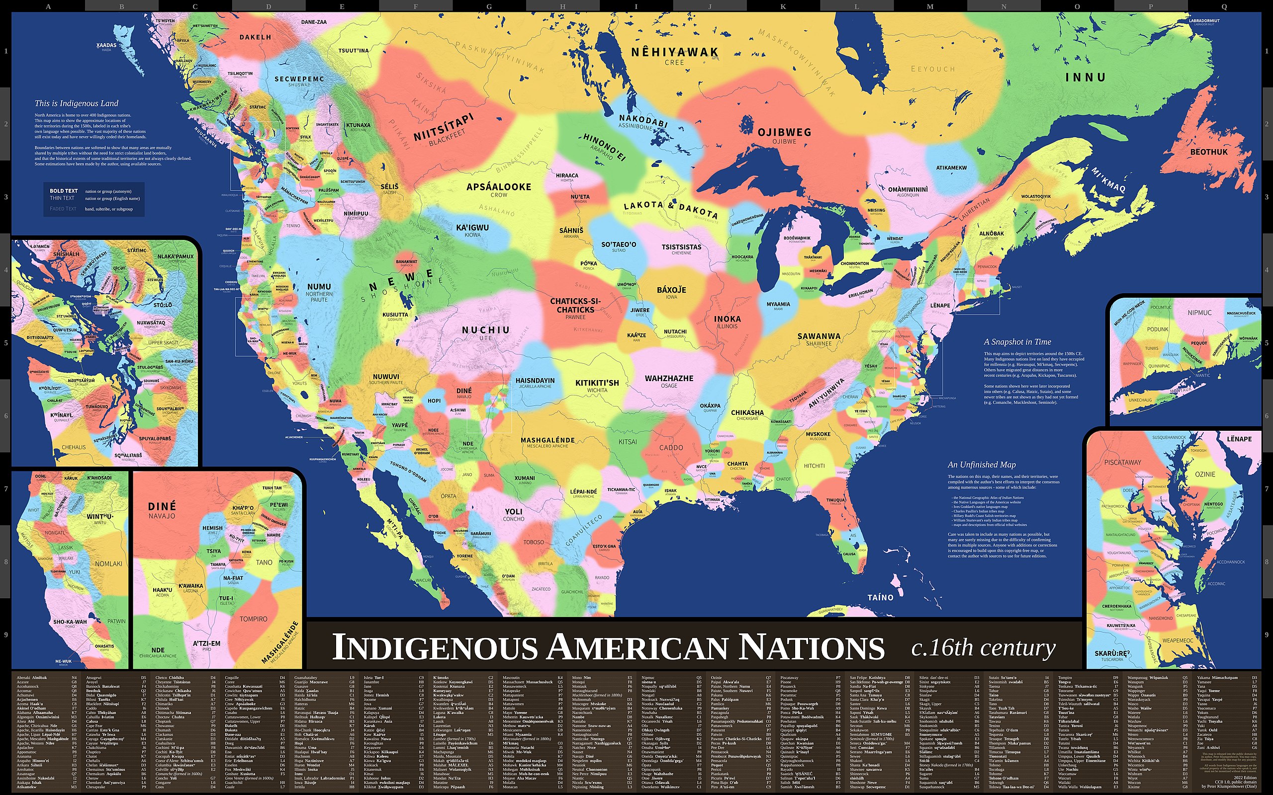
English: Map showing the approximate locations of the indigenous nations in what is now the United States during the 1500s. Nations are labeled in each tribe's own language when possible. Map uses Mercator projection. |
| 日期 | |
| 来源 | Indigenous America Maps |
| 作者 | Peter Klumpenhower |
| 授权 (二次使用本文件) |
"This map is released into the public domain by its author, Peter Klumpenhower. You may copy, distribute, and modify this map for any purpose… CC0 1.0, public domain" (See lower right corner of map.) |
许可协议
| 本作品采用知识共享CC0 1.0 通用公有领域贡献许可协议授权。 | |
| 采用本宣告发表本作品的人,已在法律允许的范围内,通过在全世界放弃其对本作品拥有的著作权法规定的所有权利(包括所有相关权利),将本作品贡献至公有领域。您可以复制、修改、传播和表演本作品,将其用于商业目的,无需要求授权。
|
文件历史
点击某个日期/时间查看对应时刻的文件。
| 日期/时间 | 缩略图 | 大小 | 用户 | 备注 | |
|---|---|---|---|---|---|
| 当前 | 2022年3月20日 (日) 20:07 | | 17,280 × 10,800(24.71 MB) | Nosferattus | Uploaded a work by Peter Klumpenhower from [https://indigamerica.blogspot.com/p/downloads.html Indigenous America Maps] with UploadWizard |
文件用途
以下页面使用本文件:
全域文件用途
以下其他wiki使用此文件:
- be.wikipedia.org上的用途
- en.wikipedia.org上的用途
- en.wikiquote.org上的用途